Data: 2014 Adopted and Maintained Detroit City Parks

cityparks

Out of 4763.78 acres of city parks, excluding golf courses and cemeteries, 3256.89 of those acres are being regularly mowed by the city or have been adopted by a community organization, church, corporation, etc. What do you do with 1506.89 acres of unmaintained city-owned greenspace? Obviously, maintaining vacant land and keeping track is difficult, but there must be a better system to keep check on these kinds of community assets.

Unfortunately, the adopted parks list, the scorecards, and the mowing schedules lists had many discrepancies in park names, spelling, etc. These various issues must have come from disparate databases. Alfonso is changed to Alonzo, Ramsey is changed to Ramsay, Dr. AW Diack Playground is listed as simply “Diak,” Max Sawyer is referred to as Sawyer Playground – I’m not sure how the city can keep it all straight. I couldn’t tell you how many double name parks were just reversed (i.e. Beland-Manning –> Manning-Beland) or hyphen versus ampersand versus “and” versus a slash. You would think that there would be a single database used within the same department. The parks are a good test case for updating and improving city databases and tracking systems. There should be a single, solid database of information on parks, adoption, and tracking.

[Detroit Park Locations – Polygons] “Location of Detroit Park Areas in polygon format (shows boundaries) including size, condition and use of park.” – Detroit Data Collaborative (D3), 02/24/11

[Parks Landmarks] “Municipal Parks and Landmark features for the City of Detroit. Includes golf courses, City Airport and civic plazas. Does not include all school parks, unless they are maintained by Detroit Parks and Rec. This layer was developed by Data Driven Detroit by adding to a GIS file that was provided by the City in 2010. Some parks in the file may have been “abandoned” and are not maintained any longer.” – D3 Open Data, 02/11/14

Even these two openly available GIS files were full of errors with naming and did not match. Not to mention the polygons were different shape and quality.

Data sources:

Highlighting: Yellow (city mowing + adopted), Red (naming discrepancy or missing from city lists)

Map: Detroit’s Class Divide

detroitcityWEB

This map comes from a series by Richard Florida of The Atlantic’s City Lab looking at class in the USA through the lens of the Census Bureau’s American Community Survey (ACS).

“[…] today’s three major classes: the shrinking middle of blue-collar workers in manufacturing, transportation, and maintenance; the rising numbers of highly paid knowledge, professional, and creative workers in the creative class; and the even larger and faster-growing ranks of lower-paid, lower-skill service workers.” (Link)

It is not surprising to see the pockets of Detroit’s creative class in the well-known neighborhoods (Lafayette Park, Corktown, East Riverfront, Midtonw Palmer Woods, Grandmont-Rosedale) that get a lot of attention while the rest of Detroiters are primarily in service worker roles. The expansive service class represents the loss of Detroit industry and the loss economic opportunity for Detroit’s residents.

More from the author:

“Much of the city outside of the downtown core has literally been abandoned. More than 25 percent of the city’s residential parcels (more than 90,000) are empty lots, and another 10 percent (33,500 parcels) are vacant homes, according to a comprehensive 2010 survey.

Detroit’s creative class is located along the lakeshore in the city, as the map above indicates, in a narrow strip that runs north along Jefferson Avenue from downtown through historic Indian Village towards Grosse Pointe. Home to Wayne State University and major arts and cultural institutions, rapidly revitalizing Midtown has also drawn a growing creative class population.

The purple blotch in the north is upscale Palmer Woods, noted for its large Tudor homes close to Detroit Golf Club. The neighborhood was founded in the early 20th century as an exclusive enclave for auto industry barons, including the founders of Fisher Body, and is where a number of Motown recording artists live today.”

Map: The Future of Detroit’s City Parks

cityparks

Parks in Detroit have had an interesting history and have had a busy few years. Some started as urban gardens on vacant land while others have been donated by families. Some parks have historic designations while others still have private land deed holders. This summer WDET has started a Detroit Park Watch blog and has been commenting on how Duggan has been managing to keep parks open and maintained. The volunteer “Detroit Mower Gang” sees fewer parks that need help, but also community gardens and greenspaces have been cleared or mown down by the city. There is also controversy over the city selling 15-acre Lipke park to the Salvation Army.

I did some mapping with parks data in 2012 when Mayor Bing announced the closing of 51 city parks, but it was very difficult since park names were listed differently in different databases. Bing was able to raise $14 million to keep the parks and recreation centers open that summer as part of the “Active & Safe” program. 119 churches and nonprofits stepped up to “adopt” parks and a 10-14 day mowing schedule was instituted for high use parks, while low use parks were placed on a 3 week mowing schedule. The program also allowed for a permanent staff member at 5 parks: Palmer, Patton, Clark , Farwell, and Lasky for daily maintenance.

Mayor Mike Duggan has continued a similar program of selecting “premier parks” (n=23) and encouraging park adoption (n=76) to keep as many parks open as possible. There is a current list of 76 adopted parks ranging from corporations to churches. Something new that Duggan’s administration has started is a scorecard for groups that have adopted a park based on how well they have maintained mowing, trimming, etc. Partners who have adopted a park are given a score between 1 and 9, the average so far is a 6 for most parks. The city has mowing schedules for 165 city parks, but these also overlap with 16 adopted parks, so it is unclear if they are scoring themselves or their park “partners.” Additionally, that leaves 112 “city maintained” parks without a clear plan. Among those 112 is one of the city’s “premier” parks, Stoepel No. 1.


Detroit Rapid Transit Planning Map 1945

det-highway-planning-1945

It is always interesting to find old transit plans in Detroit. In 1945, the plan for rapid transit was still young. You can see the East-West route slides down to Jefferson near Conner Ave and seems planned to end where the Jefferson North Assembly Plant is today. This plan I think still holds relevance today because the continued importance of Detroit’s spoke streets and main road arteries. Grand River, Woodward, Gratiot, and Michigan Avenues are all still very busy and key routes in and out of Detroit.

What stands out the most from this plan is the various modes of transit: streetcar, trolley, rapid bus routes, and even a planned subway. Just imagine if today the M-10 Lodge Freeway was instead a subway system? How many parking lots would we see Downtown?


Map: Watch Detroit’s Businesses Wake Up

Detroit_awake

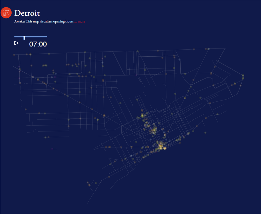
This fascinating visual from The Social Computing Group at MIT Media Lab called You Are Here relies on opening hours of Detroit businesses. By 8am the whole city seems to be awake and into the early hours of the night/morning there are only a handful of 24 hour businesses. There is obviously a lot of businesses focused Downtown, but I wonder how comprehensive their dataset is for smaller businesses outside of the Downtown/Midtown area?

They also did a cool thing where they paired down roads to the most active for businesses throughout the day.

Map: Detroit Motor Bus City Routes 1924

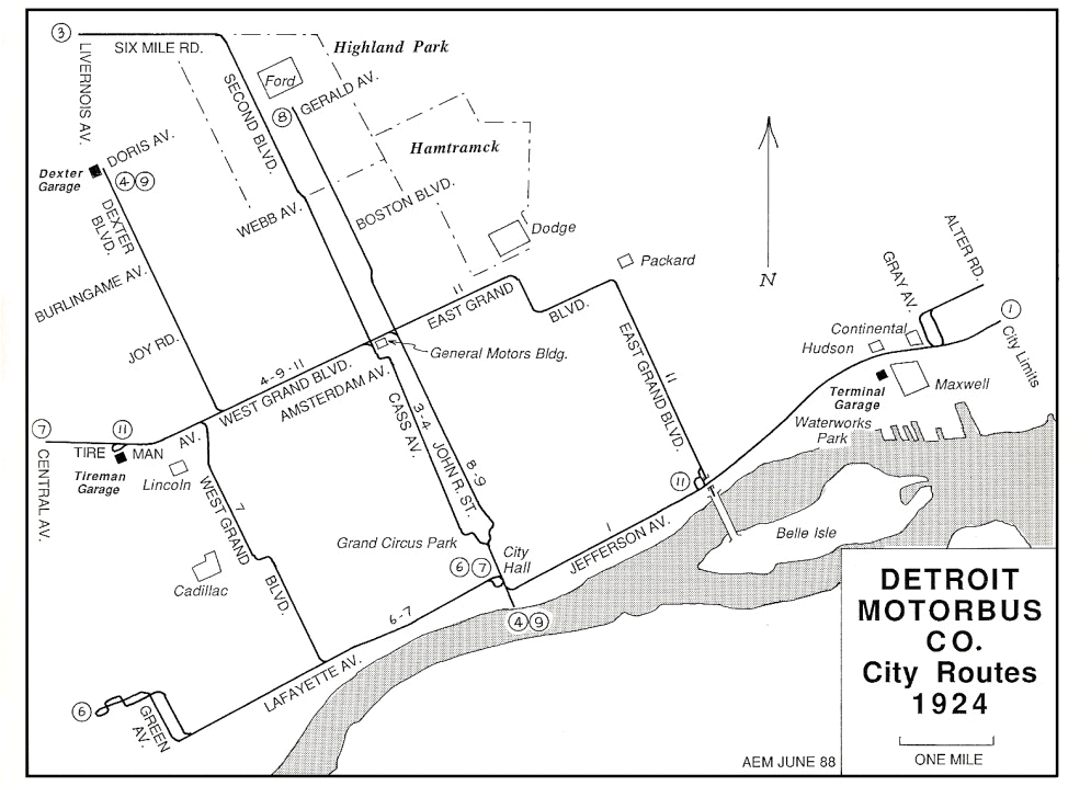
DMB_routemap-city1924I came across this map from the Detroit Transit History website and immediately thought of The Detroit Bus Company.

Organized back in 1919 by Herbert Y. McMullen (an automobile accessory and supply distributor), the Detroit Motorbus Company would become the first permanently successful transit bus company to provide motor coach service within the city of Detroit.  To help gain the support of the public as to the type of service it would be providing, the company began operating a sample prototype double-decker bus on demonstrator trips to hotels, banks and department stores within the central business district, and along Woodward Avenue.

It is hard to imagine a time when buses did not traverse the city of Detroit, but largely up until 1924 public transportation was all street railways. The Department of Street Railways (DSR) began its first bus lines in 1925. By 1930, the Detroit Motorbus Company (DMB) was running 395 buses within the city and the suburbs. In 1931, the city began negotiations with DMB to takeover its operations as a way to eliminate competition. By 1932 many of the DMB lines had been taken over by the city and many of the DMB’s suburban lines still exist as SMART bus lines today.


Map: Industrial Corridors of Detroit 1958

industrial-corridors-1958

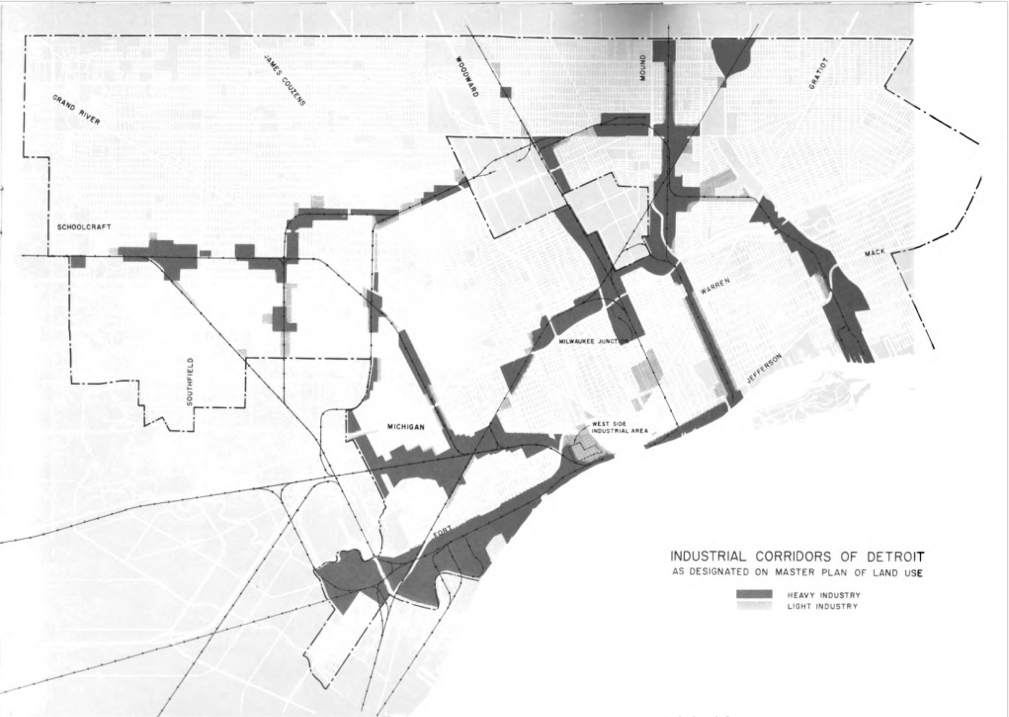
Urban renewal and redevelopments are common in any large city. In 1958, the West Side Industrial District was an attempt to revitalize and stoke some industrial activity in the area near Michigan Central Station (MCS). The introduction page of the planning report reads:

“This publication is prepared to describe a program which Detroit is undertaking to clear one of its oldest and most blighted residential districts and to prepare it for rebuilding by means of federal assistance provided in the Housing Act of 1949.”

The hope was to capture “modern industry” through warehousing and plant locations with rail access and plenty of space. While there is an area of Detroit known as “West Side Industrial” the modern industry is lacking. Some have decided (jokingly?) to ironically refer to the area (and Hubbard-Richard neighborhood) as Corktown Shores.

Map: Detroit Rambling recreates the Smells of the Midtown Loop

midtownloop-day062714

jacqui Au of the Detroit Area Rambling Network took some time and recreated my “smells of the Midtown Loop” map with her own smell experiences. Additionally, with some beautiful hand drawn maps! Here is an excerpt from her post:

“Daytime is much smellier for the Midtown Loop than night, with thirty-two scent events compared to eighteen after hours. While I wasn’t struck by its unpleasantness while walking, exhaust fumes were abundant on my daytime loop, accounting for eight scent events where traffic lined up at stoplights. The nighttime walk was dominated by five great woodsy whiffs of fresh mulch. More mysterious scents floated through the night air — chlorine, gasoline, and a funny plastic reek, none of which had an origin visually evident.”

She concluded that the Midtown Loop was designed more for visual than scent experience. jacqui walked the loop both during the day and night to do a comparison.

“The relatively clear air after dark is a significant benefit for pedestrians uninterested in basking in noxious fumes and harmful particulates as they stroll along a greenway.”

Thanks jacqui!

Map: Thrift Gardens in Detroit 1934

IMG_0267

Thanks to Joe Cialdella, PhD candidate at University of Michigan for sharing this map and great info. Joe has been researching the history of urban farming and gardening in Detroit. He recently published “A Landscape of Ruin and Repair: Parks, Potatoes, and Detroit’s Environmental Past, 1879-1900.”

This map appeared in the Annual Report of the Thrift Garden Committee, 1934, which is part of the Detroit Thrift Gardens manuscript collection at the Burton Historical Collection at the Detroit Public Library.

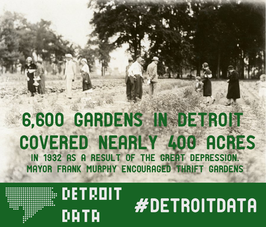
I wrote last week about the data shared by the Detroit Historical Society. There were 6,600 gardens covering 400 acres in Detroit in 1932. It is interesting to see most of the thrift gardens around the outer edges of the city where there were smaller populations and likely more open land to use for gardening. How many of these remain as gardens or parks today?

Data: 60 Dan Gilbert Owned Properties in Detroit

dan_gilbert_properties

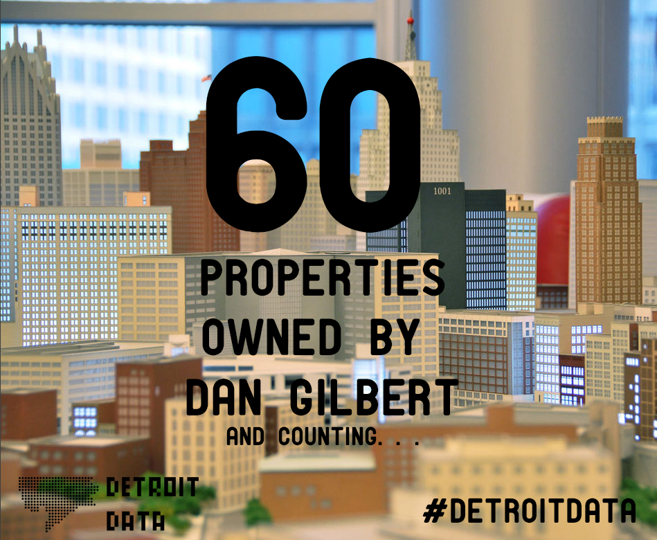
If you’ve heard about Detroit, then you’ve definitely heard about Dan Gilbert. The CEO of Quicken Loans has been buying up properties in Downtown Detroit and implementing his own plan of change and revitalization as he goes. He has increased business capacity and brought more businesses to the Downtown area. While some see Gilbert’s purchasing as a sort of takeover, the lasting impact of Gilbert’s efforts in Detroit are yet to be seen. Recently, Gilbert has had to face-off with other potential buyers when he used to be able to more easily purchase what he wanted.

Help us update our list and fill in missing information. Leave a comment on a particular cell of the spreadsheet if you have more information. Thanks! Access the spreadsheet HERE

Map: Top 40 Delinquent Commercial Water Accounts in Detroit

detwater

A list was finally published of some of the top commercial water customers with delinquent accounts. They have ranged from companies who have been in trouble in the past with Michigan’s Licensing and Regulatory Affairs (LARA) to individuals who seem to have attempted business ventures that failed. What is most surprising is that among the top 40 delinquent commercial accounts there is a cluster in Midtown and Downtown – the newly named “Innovation District.”

The Detroit Water and Sewage Department (DWSD),a not-for-profit by Michigan mandate, estimates that 18,073 commercial accounts make up about $26 million of the deficit or almost a quarter of accounts past due.

We looked into a few of these corporations and found some odd things:

  • Vargo Golf – with the highest amount past due, manages six golf courses in metro Detroit with three in the City of Detroit – Palmer, Rouge, and Chandler.
  • Borman LLC was taken to court in 2010 for defaulting on a commercial mortgage, the property at 18718 Borman St. is a large industrial property located where I-96 and Southfield Fwy meet.
  • Metro Livernois LLC received millions in brownfield redevelopment funds for work on the Metro Plaza Redevelopments, it is unclear what or where that project is
  • State of Michigan-DMB, one of the downtown locations, claims that it doesn’t owe the city this money
  • G F H Enterprises could not be found listed anywhere
  • Brodhead Armory, built 1930, has not been used by the military reserves since 2004. Check out the abandoned building on detroiturbex.

Peruse the full list of data HERE, let us know if you have other information on any of these accounts.

detroitdata_get

Detroit Map Cutout at City Bird

photo (13)

The boutique shop, City Bird, located in the Design District of Cass Corridor within the Midtown area, has a nice wood cutout of Detroit hanging on their wall. The accuracy may be a little off (Southwest squiggle), but it is always fun to see a map of Detroit as interior decor. The shop carries a wide variety of Detroit map goods from cutting boards to beer glasses and postcards.

Map: StreetScore algorithm of safe streets in Detroit

streetscore

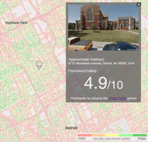
I came across this new exciting tool for perceived safety in cities. Among New York, Boston, and Chicago was also Detroit. I was almost too excited that Detroit was being geographically studied alongside those other cities until I read into the project further.

Place Pulse aims to quantitatively recognize which areas of a city are perceived as wealthy, modern, safe, lively, active, unique, central, adaptable or family friendly.

With enough user participation, Place Pulse can identify which neighborhoods in Bangkok are perceived better than neighborhoods in New York City or to examine how the distribution of a certain perception in Mexico City compares with that same perception in Tokyo.

For curious researchers, the Place Pulse dataset can even be used to study the association between urban perception and other datasets, such as violent crime, creativity or economic growth.”

Place Pulse creates its output via an algorithm called StreetScore that depended on at least 7-10 clicks per city image, of which there are about 100,000 for 54 different cities (not including Detroit). The StreetScore algorithm was then applied to Detroit based on characteristics found in other cities. However, I’m not sure how well it matches with Detroit.


streetscore_good

Streetscore assigned this vacant house on the Eastside with a high score although the area is not the most well maintained. I can only assume that the algorithm saw a lot of greenery in the image and thought it was a park or green space. I clicked on a number of highly scored vacant lots and abandoned houses, which I would have given very low scores.

streetscore_bad

The flip side was also true. Locations where I have driven and walked show up with low scores. This particular example is St. John’s Church with grass mown, cars always out front, and an obviously well cared for building. This church is located in not the best area, but this particular image would make me feel more safe than an abandoned building.

I think the StreetScore is an interesting idea, but it is too difficult to quantify perceptions, which are inherently qualitative and likely vary for people across cities, countries, and continents.


Map: Social Justice Impacts of Transit Reductions in Detroit

transit reductions

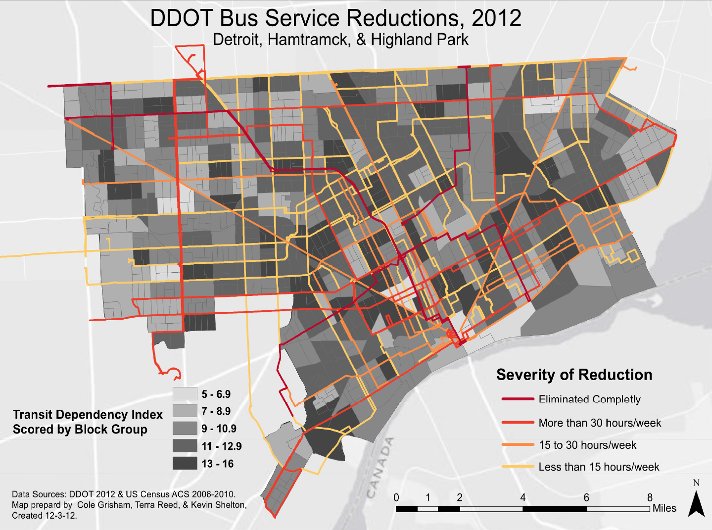
University of Michigan graduate students Nicholas Grisham, Terra Reed, and Kevin Shelton found that the 2012 reductions in DDOT bus service affected almost all routes whether it was a reduction of hours, days, or the entire route. They also found that transit dependency was spread out across the city. They developed a Transit Dependency Index (TDI) based on Census data of: vehicle ownership, elderly population, youth population, and median household income.

Their question was whether bus reductions disproportionately affected transit dependent residents more than others. The answer was yes, but the impact also reached across the city.

Find the entire presentation HERE

Data: 6,600 Detroit Gardens in 1932

thrift_gardens

When the Great Depression hit, Detroit’s auto industry production fell by 75% between 1929 and 1932. Many were left without work or an income to pay for food, housing, etc.

Anyone know where we might be able to find some info on where these gardens were located? Where were vacant lots turned into farms and gardens?

Source:

Map: Residential Density & Walkable Schools in Detroit

detroitps-map-a-final

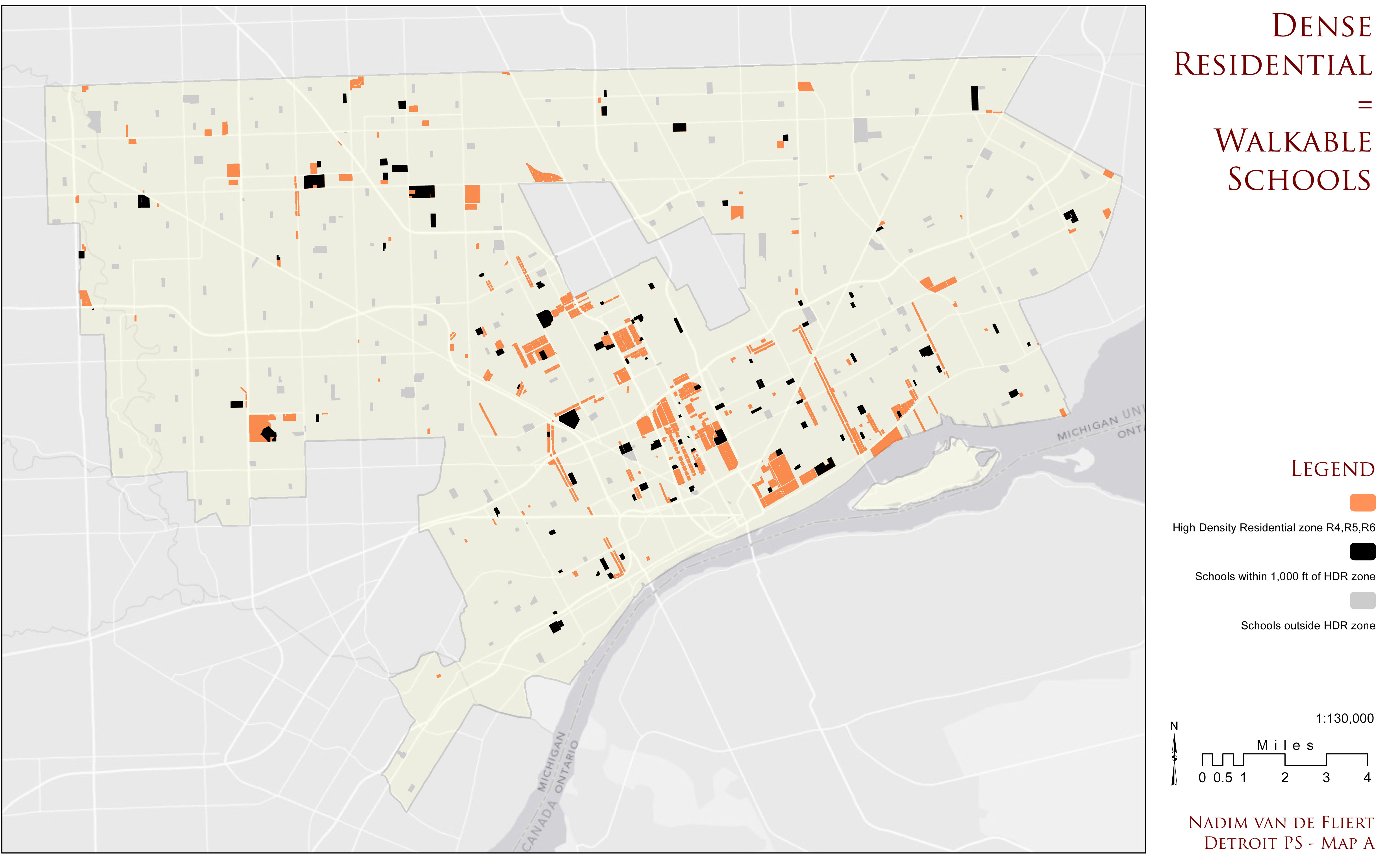
U of M student Nadim Van De Fliert created this map to demonstrate the need for more dense residential development as a way to support better, community-centered schools. More from the author:

Map A reveals the residential zones classified as R4, R5, and R6 – the highest density residential (HDR) zones in the city.  Those schools within 1,000 feet of the high density residential zones are highlighted in black.  1,000 feet was chosen to roughly estimate the east-west distance of a standard New York City block.  Imagine turning the corner on a nice leisurely stroll to school with your classmates and seeing your destination just a few hundred paces further ahead.  At this point, it’s a dead sprint – racing to be the first at the front door.  This is an ideal for which to strive, perhaps.

What’s missing:

  1. Data sources
  2. 1000 foot radius around schools? Where do the ideas converge?
  3. Don’t use the equal sign for a hypothesis (dense residential = walkable schools)

M1 Rail Map on Downtown Detroit Window

photo (11)

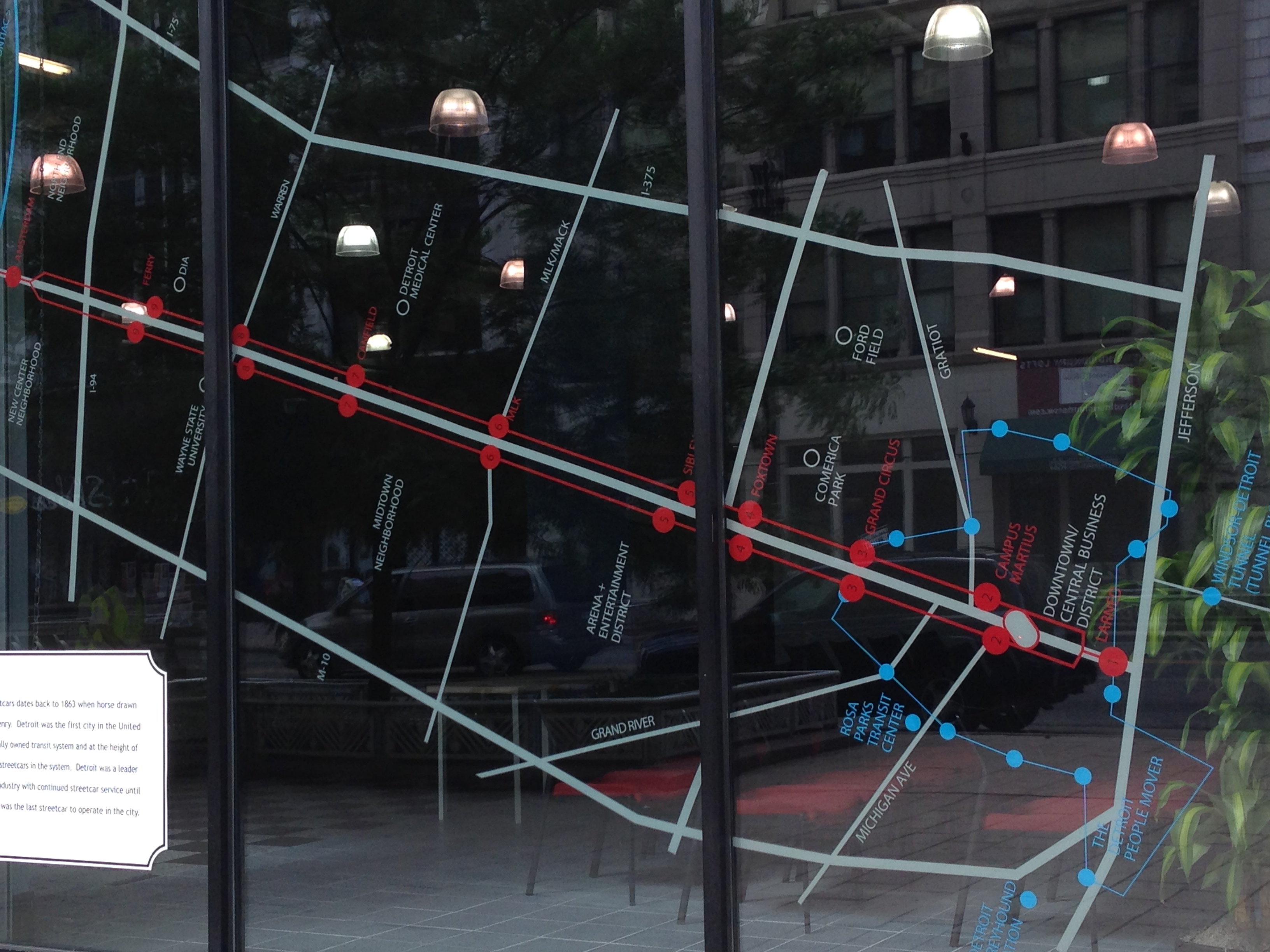
Spotted along Woodward, this window map stood out on a walk Downtown. After months of slow prep work being completed underneath Woodward Ave., the M1 Rail now has an official breaking ground date: July 28th. This also means that Woodward Ave. will be closed from Adams St. to Campus Martius for about 3 months. Be sure to attend one of the two upcoming community meetings.

Visit: http://m1rail.com for more details.

Map: Colleges and Universities in Detroit

college_univ2

In recent years Detroit has seen an influx of college and university satellite sites. Notably, the University of Michigan (UM) Detroit Center opened in 2005 while the Michigan State University (MSU) Detroit Center opened in 2009. Detroit has been host to a number of colleges and universities from its founding. As Michigan’s largest city and former state capitol, Detroit held the greatest number of highly educated individuals. In 1817, Justice Woodward wrote up plans for the University of Michigania (Catholepistemiad) with 13 departments. The building was constructed at Bates and Congress, but due to disagreements over educational ideas, controversy with the land, and general mismanagement, the university never really took off. Land that had been previously earmarked for a new Michigan state capitol soon became the new University of Michigan in Ann Arbor under the leadership of Henry Tappan in 1837. UM’s proximity to Detroit has afforded many “urban research” opportunities for faculty, staff, and students.

Central Michigan University (CMU) and Grand Valley State University (GVSU) have both set up satellite locations in the last few years. Lawrence Technological University (LTU) is moving its Detroit Studio from New Center to a new building under-construction at Woodward and Willis.

Wayne State University (WSU) in one form or another has been educating student since 1868. It began as the Detroit Medical College. The iconic “Old Main” building was constructed for Central High School in 1896, but then became the Detroit Junior College and then the College of the City of Detroit. In 1934, a handful of small colleges were combined to create Wayne University. The Law School, School of Social Work, and School of Business were added and in 1956 it was constitutionally established (Michigan) as a public institution by the name Wayne State University. Additionally, WSU has an Oakland satellite campus just northeast of the city limits.

Marygrove College (MG) moved to Detroit in 1927, it had previously been known as St. Mary’s College. The college was a women’s only institution until 1970. The college prides itself on Catholic social teachings and actions. The fenced in campus off of W. McNichols has an Oxford University appearance with its grand buildings and architecture.

University of Detroit Mercy (UDM) was founded by the Jesuits (Society of Jesus) as Detroit College in 1877 and expanded to the University of Detroit in 1926. The Mercy College of Detroit was established in 1941 and was then consolidated with the University of Detroit in 1990 to form the University of Detroit Mercy. UDM is best known for its Dentistry program and growing Law program.

Wayne County Community College District (WCCCD) was founded in 1967 downtown Detroit. Currently with six separate campuses across the county (3 within Detroit) with an emphasis on career programs plus traditional college programs, such as Liberal Arts.

The College of Creative Studies (CCS) was formed in 1906 from the Art School of the Detroit Society for Arts and Crafts. Over a two decades of slow expansion, the college began offering one of the first arts and crafts 4 year degrees in 1926. It was known as the Center for Creative Studies—College of Art and Design until it was renamed in 2001 as the College of Creative Studies.

Timeline of Detroit Higher Education:

  • 1817 University of Michigania (UM)
  • 1837 University of Michigania leaves Detroit (UM)
  • 1868 Detroit Medical College (WSU)
  • 1877 Detroit College (UDM)
  • 1906 Art School of the Detroit Society for Arts and Crafts (CCS)
  • 1926 University of Detroit (UDM) & Center for Creative Studies—College of Art and Design (CCS)
  • 1927 St. Mary’s College moves to Detroit as Marygrove College (MG)
  • 1934 Wayne University (WSU)
  • 1941 Mercy College of Detroit (UDM)
  • 1956 Wayne State University (WSU)
  • 1967 Wayne County Community College (WCCCD)
  • 1990 University of Detroit Mercy (UDM)
  • 1999 Lawrence Technological University Detroit Studio (LTU)
  • 2001 College of Creative Studies (CCS)
  • 2005 UM Detroit Center (UM)
  • 2009 MSU Detroit Center (MSU)


det_univ_downtown

Downtown/ Midtown are the obvious focal point for the majority of colleges and universities located within the city. The Lodge Freeway and Woodward Avenue are popular thoroughfares for getting around to educational institutions.

Screen Shot 2014-07-02 at 8.11.49 AM


GVSU members have the longest to travel at 169 miles to get to their Detroit location. My theory is the GVSU building is mainly a marketing piece with its prime name display location behind Comerica Park. CMU comes in second at 154 miles while MSU is 81.2 miles. UM members travel half that distance at 42.3 miles. This all just goes to show the influence of Detroit as both a regional and statewide center for knowledge.

Map: Detroit Regional Population Cartogram 1970

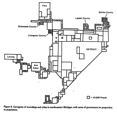
detroit_cartogramThis is a classic William Bunge map/ cartogram showing the population sizes of various southeastern Michigan municipalities reaching up to Flint and as far over as Lansing. When this was made in 1970, Detroit dominated the population charts. The city still dominates in regards to population size compared to its neighbors despite the recent population losses.

Data: Water Shutoffs and Delinquent Accounts in Detroit

dwsd_water

The worst offender of the delinquent water accounts and overdue bills is the City of Detroit, in particular the parks. Palmer Park alone has an outstanding bill of $422,295.40. Many of the residential properties with outstanding bills are abandoned homes that haven’t been lived in for many years.

The fire hydrant pictured flowed for a full 6 days even while 4 separate nearby employees made 5 different calls to report it to the Detroit Water and Sewage Department (DWSD). The hydrant was not shut off until a tweet was sent to the Mayor with the estimated water wasted = 1.5 million gallons (if PSI = 1). The week before a hydrant behind Detroit Receiving flowed for a full 7 days before getting shut off.

Water bills in Detroit are twice the national average of $40 and the City Council approved a 8.7% bill hike just last month along with controversial plans to privatize DWSD. For many Detroit residents already struggling to make ends meet, this is another burden when a delinquent water bill might represent 20% of their income.

Water is a human right and there should never be a need to take basic needs away from people. Catarina de Albuquerque, expert on the human right to water and sanitation, from the United Nations Office of the High Commission on Human Rights (UNOHCR) responded to an appeal about the water shut offs, saying:

“Disconnections due to non-payment are only permissible if it can be shown that the resident is able to pay but is not paying. In other words, when there is genuine inability to pay, human rights simply forbids disconnections,” said Catarina de Albuquerque, the expert on the human right to water and sanitation.

My hope is that Mayor Duggan will take a lesson from Mayor Frank Murphy who, during the Great Depression, chose to feed the hungry and turn empty factories into boarding houses for the poor. Balancing the books doesn’t have to come at the expense of Detroit residents already facing economic difficulty.

“no one in this great city of plenty…must be allowed to go hungry, or cold, or unhoused, or unclothed.” – Frank Murphy

Data:

Source:

detroitdata_get

Map: Jewish Migration in Detroit 1840 – 1965

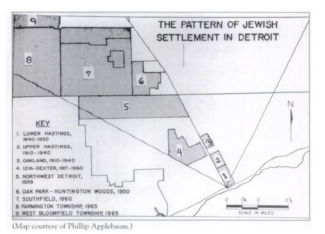
Screen Shot 2014-06-20 at 10.05.12 PMThis map appears in the book by Irwin J. Cohen titled “Jewish Detroit.” In the introduction he writes that he was able to complete the book by spending many hours in the Burton Historical Collections at the Detroit Public Library. Cohen covers the history of Jewish settlement in Detroit from the first Jewish resident in 1762 to the burgeoning congregation of Beth El Temple before Detroit’s Jewish population began its Northwestern migration to what are now Detroit’s affluent suburbs.

The Jewish community was more open and welcoming than others to the Black community and many of these areas became historic neighborhoods of Detroit’s Black community as the Jewish community migrated Northwest.