Map: Pharmacies are Detroit’s Closest Retail Amenity

Detroit-Pharmacy-Map

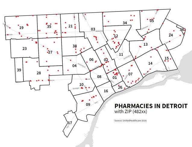
In the March 2017 report, “Going the Distance: Big Data on Resident Access to Everyday Goods” the J.P. Morgan Chase Institute identified pharmacies as leading accessibility point for Detroit residents. The report compared data for both New York City and Detroit and found that in both cities the majority of residents shopped for retail goods outside of their 20-min neighborhood area.

Pharmacies came in at #1 with an average distance of 0.9 miles away with grocery stores a close #2 at 1.4 miles on average. The analysis was run with ZIP code filling in for neighborhood and ZIP code centroid being used to calculate distance which causes some issues when trying measuring distance of residents to retailers. The analysis was limited by ZIP code due to use of a credit/debit transaction database that only geotags ZIP code.

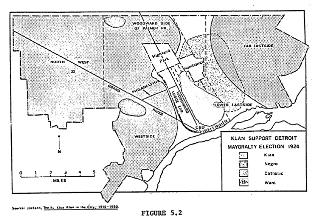
Map: Klan Support in Detroit Mayoral Election 1924

Screen Shot 2017-08-23 at 8.32.38 AM

This map was created by Donald Deskins Jr. as part of his PhD dissertation on “Residential Mobility of Negro Occupational Groups in Detroit 1837-1965” at the University of Michigan in 1971.

He wrote:

“Immediately following World War I, Klan membership in Detroit numbered in the thousands. […] Claiming a 200,000 local membership, this group was very active during this period. So active in fact that the Klan-supported write-in candidate would have become mayor of Detroit in 1924, had it not been for 17,263 ballots which were declared invalid due to misspelling, etc.

Figure 5.2 portraying the areas in Detroit where Klan support was strong, makes it apparent that the Klan support was almost ubiquitous except in ethnic areas on the east side and in the Negro community. Strongest Klan support was located between the city’s two major Negro enclaves in the triangular area defined by Grand River, Philadelphia and the John C. Lodge Expressway.

Map: Detroit and the 2017 Solar Eclipse

detroit-eclipse-17

Detroit is not in the “path of totality” that will see the moon 100% obscure the sun, but we will be in a prime location to experience 80% obscurity.

As far as I can find there is only one event in Detroit to see the solar eclipse. The Michigan Science Center will be open from 12:00PM to 5:00PM. They note that the eclipse will happen between 1:03PM and 3:47PM with 2:27PM being the best time to see the most of the eclipse.

DO NOT LOOK DIRECTLY AT THE SUN!

EVER!

NOT EVEN DURING THE ECLIPSE. DO NOT TRY TO VIEW THE ECLIPSE THROUGH A CAMERA OR CELLPHONE.

Map: Detroit’s Pet Service Desert

aa-so16-detroit-map-800

Yet another layer to the “food desert” metaphor has been added by new efforts from the Humane Society called “Pets for Life.”

Through Pets for Life, The HSUS has led the charge to make pet care services more accessible, preserving the bond between families and their companions and flipping that statistic on its head. Around 80 percent of PFL clients with unaltered pets end up getting the surgery done through PFL.


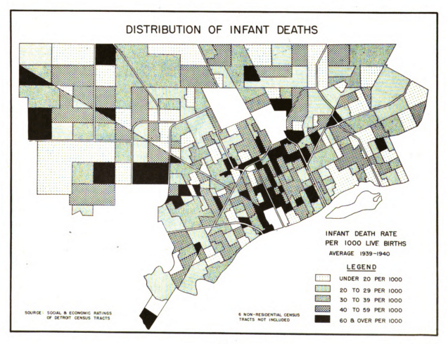
Map: Infant Deaths in Detroit 1939 – 1940

Screen Shot 2017-07-27 at 7.45.20 AM.png

Infant mortality has been a primary health focus area for a very long time in Detroit and across the country as it is an important marker for the overall health of a place. This map from the Detroit City Plan Commission’s report titled: “The People of Detroit.” The legend creates even categories for the data, but you can still see a higher concentration in the city’s central core near Downtown within the ring of Grand Boulevard.


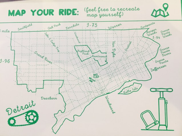
Map your own Detroit Bike Route

img_1919

MOCAD and Back Alley Bikes have partnered to host a youth “earn-a-bike” workshop August 21-25 this summer.

For their flyer to promote the program they’ve included this excellent map of Detroit that includes no expressways so that you can plan your bike route along the dashed road lines.

More hand drawn maps please!

Map: Detroit Riot Crimes 2009 – 2016

riot-crimes-2009-2014 copy.png

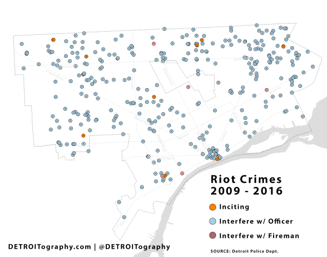
This map includes all criminal incidents that are coded by the police as “riot” which in most cases involve “disorderly conduct” and interfering with a police officer or fire personnel. Since 2009, there have been 323 riot crimes, but only 11 of those were for “inciting a riot.”

Urging or instigating other persons to riot, but shall not be deemed to mean the mere oral or written (1) advocacy of ideas or (2) expression of belief, not involving advocacy of any act or acts of violence or assertion of the rightness of, or the right to commit, any such act or acts.” 18 USC

Detroit has a long history of civil disturbances with the first such incident recorded in 1783, Chief Pontiac’s Rebellion. Racially charged incidents followed in 1833 with the freeing of the Blackburns who were being held as “fugitive slaves” and in 1850, recorded as the Abolitionist Uprising, which required three militia units to quell. The 1863 Faulkner Riots were the first race riots fueled by misinformation and racial hate. The result of the Faulkner Riots was the creation of Detroit’s first police force. Other well-known “riots” have been instigated by White mobs in 1925 at the home of Ossian Sweet, in 1942 at the Sojourner Truth Housing site, and the 1943 Belle Isle Race Riots.

The 1966 Kercheval Mini-Riot was a precursor to the 5-day 1967 Rebellion. As many have noted, never had Detroit’s civil disturbances required the calling up of federal troops as paratroopers took to the city streets. The end was not 1967, tensions remained high and have continued. In 1975, Mayor Coleman Young attempted to calm crowds after a White bar owner shot an unarmed Black teenager in the Livernois-Fenkell Riots.



Map: Detroit’s Precinct 4 Patrolman’s Beat Map 1918

Screen Shot 2017-07-27 at 7.20.49 AM.png

This example beat map is included in the 1918 Annual Report of the Detroit Police Department.

“Beat Maps: Each patrolman is furnished with a map of his beat upon which is designated all public buildings, all factories, and other important risks, so that he may intelligently patrol his beat.”

Event: Detroit Home Movies and Hand Maps at the DIA

HIA-handmap-workshop

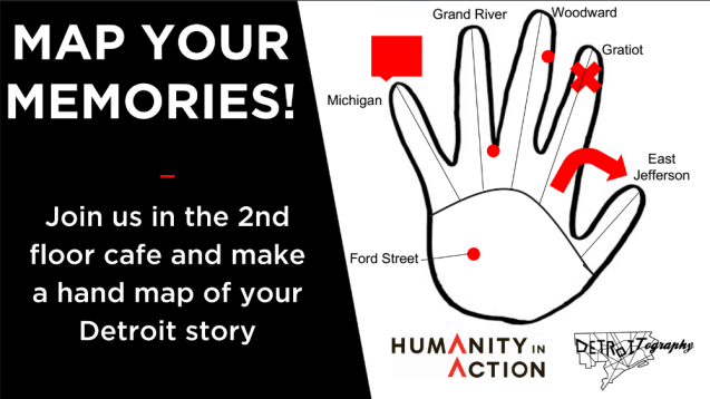
In collaboration with Humanity in Action’s Detroit Fellows and the Detroit Institute of Arts, we will be creating and collecting hand maps during the “Detroit Home Movie” showings.

Come find us in the upstairs, 2nd floor cafe to make your own hand map of your Detroit memories.

Read more on the DIA’s site: HERE

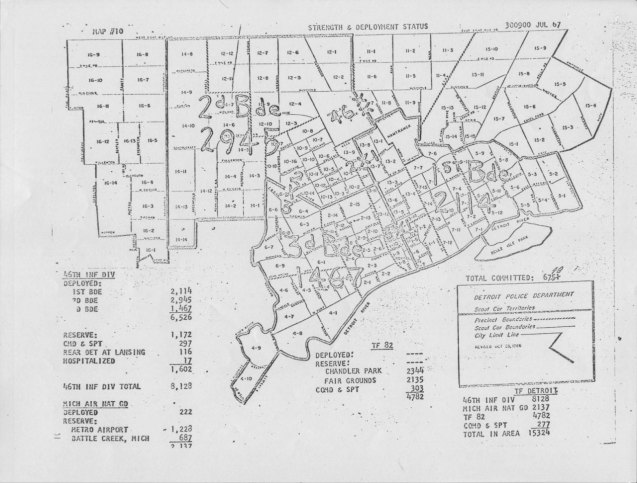
Map: Detroit Troop Strength 1967

LBJLibrary_troop_deployment_1967

July 25, 1967. 2:30 AM. The first paratroopers arrive in Detroit. 43 people are already dead, 324 injured, 7,231 arrested. The riots will continue for several more days, and there will be troops on the ground through July 30th.

Source:

LBJ Presidential Library

Detroit troop strength map, 7/23/67, Ex HU 2, WHCF, Box 26, LBJ Library.

Map: Reuther Library compiles 1967 reports to Mayor Cavanagh

IMG_1684.jpg

Detroit’s museums have all pulled together incredible time capsules and commentaries on the events on the Summer of 1967.

The Reuther Library has an excellent archival exhibit in their lobby that is accompanied by a web exhibit with related archival materials. This map in particular was created based on letters and calls made to Mayor Cavanagh’s office during the period of unrest in 1967. All of these incidents were unconfirmed reports made by members of the Detroit Commission on Community Relations.

Map: Affordable Housing in Detroit 2016

screen_shot_2017-05-16_at_4.37.29_pm_2.png

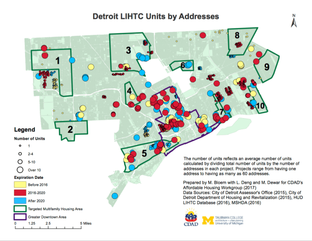
Affordable housing is at an odd crossroads in the fluctuating, contradictory, and confused real estate market of Detroit. The City of Detroit has touted “affordable housing” agreements with many developers and has also committed to keeping  seniors in their HUD housing.

Researchers from the University of Michigan found that the majority of expiring HUD housing units are located in Greater Downtown where they are most likely to be flip to market rate apartments and drive longtime Detroiters out. Currently, there are more than 2,000 units receiving the federal Low Income Housing Tax Credit (LIHTC) that will expire between 2016 and 2020.

In his “State of the City” address, the Mayor highlighted the city’s effort with the Rockbury group to secure 2 subsidized housing contracts from expiring so that 165 residents could stay in their homes.

Map: Life Expectancy in Detroit 2004 – 2013

LE-Detroit-map.png

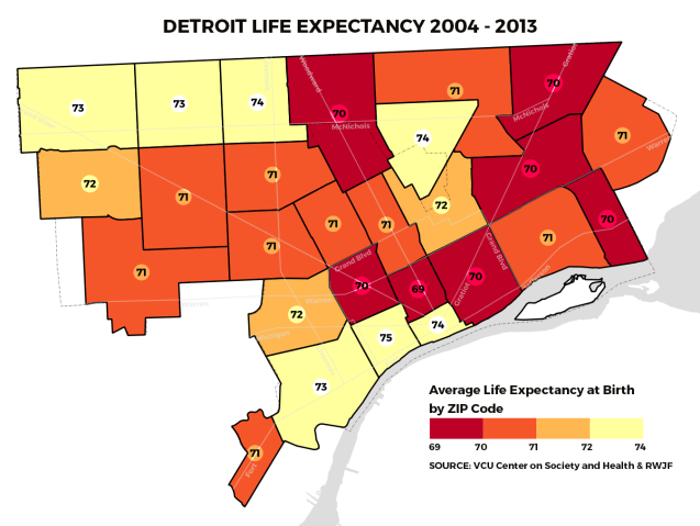
The Center for Society and Health at Virginia Commonwealth University (VCU) worked with the Robert Wood Johnson Foundation to create life expectancy maps for city across the United States.  The death data came from MDHHS Vital Records and Health Statistics and was paired with Census data from 2000 and 2010 to generate a 10-year average.

The geography of life expectancy in Detroit varies with Downtown/Corktown/Southwest presenting the longest life expectancy along with much of Northwest Detroit and Hamtramck. If you took a drive East to Harper Woods life expectancy would be 77 on average or to the Grosse Pointes where life expectancy is 82 years. Social determinants of health are influential factors from school systems, health facility availability, and access to various opportunities that are lacking in the city.

Map: Cadillac’s Detroit Illustration 1702

detroit-cadillac-1702

Hat tip to Paul Sewick for this great map find!

You’ve really got to zoom into the original from the Burton Historical Collection to realize that Antoine de la Mothe Cadillac wasn’t just drawing Lake St. Clair, but Fort Pontchartrain and the three nearby Native American village settlement.

Map: Discover Corktown 2013

corktownmap

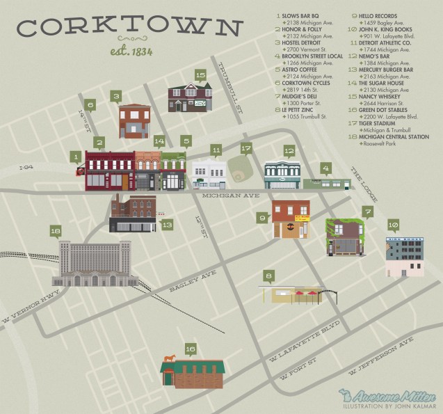
In 2013, Awesome Mitten put together a quick guide to new and changing places to visit in Corktown and included this nice illustrated map.

It’s interesting to see what was left off the list and also what has changed. St. Cece’s is closed, the Old Tiger’s Stadium site is under construction, the Corktown Inn (Trumbull and Porter Hotel) has had a major facelift, there are multiple new restaurant and retail spots, including: Katoi (before-the-fire), Two James Distillery, Gold Cash Gold, Ottava Via, Rubbed, Batch Brewing, Bucharest Grill, Detroit Institute of Bagels, Metropolis Cycles, Happier Camper, Detroit Artifactry, Detroit Grooming Company, and The Farmer’s Hand). Corktown is still waiting for development at Michigan Central Station and the CPA Building is still in unknown limbo, but the “Elton Park” residential development is moving forward.

Map: The Shrinking of Hamtramck 1825 – 1922

hamtramck-1825-1922.gif

Named for Colonel Jean-François Hamtramck, who fought for the Americans in the Revolutionary War, the City of Hamtramck is an oddity being surrounded by the City of Detroit. The story of Hamtramck’s evolution is more so the story of Detroit’s desire to annex more land area.

Col. Hamtramck founded the area in 1798 after helping to take Detroit from the British. The Village of Hamtramck was formally established in 1901 and became an incorporated city in 1922 in order to stave off further annexation of the Hamtramck Township territory which used to extend into the Grosse Pointes to the East and as far North as 8 Mile, then known as Baseline Road.

If you live anywhere on the Eastside or in the Grosse Pointes you’re more of a Hamtramckan than you might think.

Map: Village of Woodwardville Detroit?

woodwardville-map

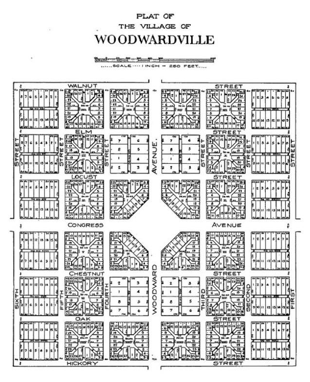
After the flop that was Judge Augustus Woodward’s “Plan of Detroit,” he purchased 8 adjacent plots in the “10,000 acre tract” and planned yet another never to be realized city, Woodwardville. Clarence Burton describes it as a “paper city” in an effort to “boom the lands adjacent to the cities.”

Read more from Paul Sewick on Detroit Urbanism:

Centered around Woodward Avenue north of what is now the Davison Freeway, the village was laid out in somewhat conventional rectangular blocks.

Fantasy Map of Detroit

middle-earth-detroit

This Middle Earth inspired map design comes from Stentor Danielson (Mapsburgh), professor of geography and artistic cartographer.

Inspired by the maps in antique atlases and fantasy novels, this map shows Detroit (along with Ann Arbor and Windsor Ontario) as a fantasy land of castles and dragons.