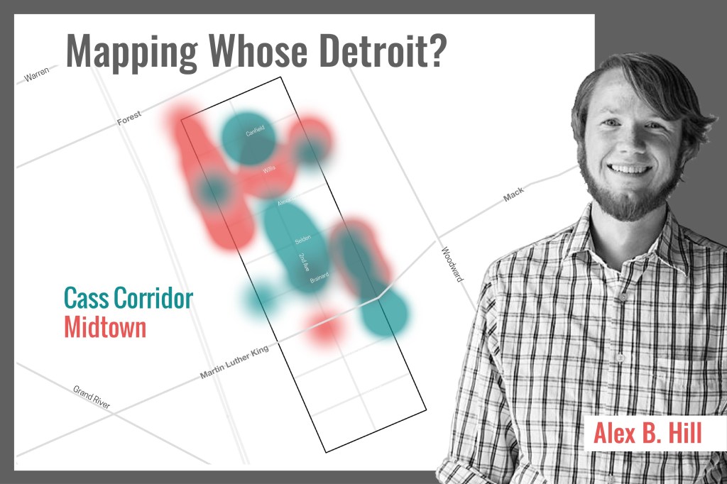
Alex B. Hill creates maps that reveal so much more about Detroit, a city in transition, than typical street maps, tour guides or headline news could ever do. His blog, DETROITography.com, uses maps to illustrate concerns and accomplishments of the city’s residents and businesses. An anthropologist and a self-described “data nerd,” Hill will be presenting a program you won’t want to miss!
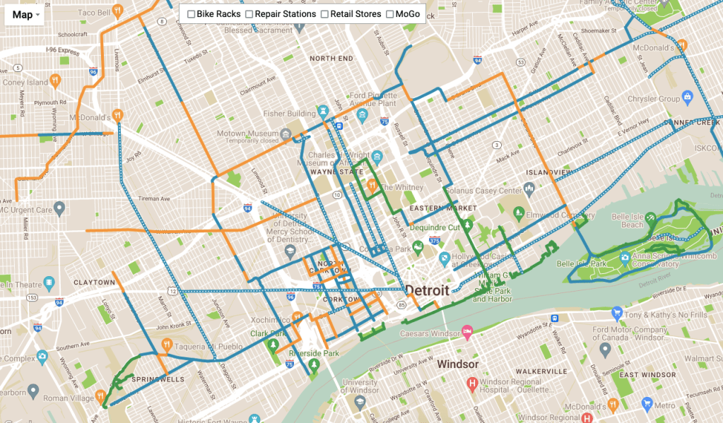
The Detroit Greenways Coalition has a new interactive bike map that compliments the print version they published a few years ago. Todd Scott has been leading on bicycle data collection, adding bike lanes to Google Maps, and sharing bicycle information for over a decade.
Parking lots. As is the Detroit and Downtown way, much of the city’s cultural heritage was razed for car infrastructure – be it freeways or parking lots.
The discussion of Chinatown in Detroit is usually limited to the decorative marker at Cass and Peterboro that disappeared and then a new one was installed reminding us that Chinatown once existed. However, the Chinatown we think we know was a failed attempt at relocation after the original Chinatown was condemned and demolished for the Lodge Freeway project.
I had always heard or been told that the original Chinatown was at the intersection of Third and Michigan Ave and/or the site of the MGM Grand Casino. After some digging into the photo archives at the Reuther Library and combing through Sanborn Digital Maps, I was able to locate the original locations of the Chinese Cultural Building and the famed Chung’s Chop Suey.
There should, in the least, be a historic marker on the lawn of the Detroit Public Safety HQ to mark Detroit’s original Chinatown.
Slow news day. On Friday, the City released a news brief about the 2 million daffodils planted by City teams in time for summer. The reason we get excited is they also have a map!
The real question is: where is the daffodil data on the open data portal?
HT @polarbarrett
Breaking news on the daffodil beat: Detroit planted 1.4 million of the spring bloomers +6K this year and they're getting ready to pop. The city put out this map to help you find them.
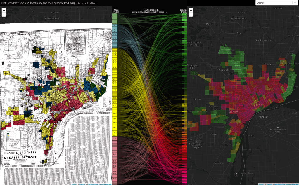
The Mapping Inequality project that has been cataloging “redlining” maps from the Home Owner’s Loan Corporation (HOLC) and completed this incredible project to match the mortgage security grading with the present day CDC Social Vulnerability Index (SVI).
The focus on redlining is often over emphasized and this analysis shows how the “yellow” graded areas (yellow-lined) experienced the most change. Many yellow areas (outside of Detroit) became green with very low SVI as well as the majority of yellow graded areas within Detroit became red with very high SVI.
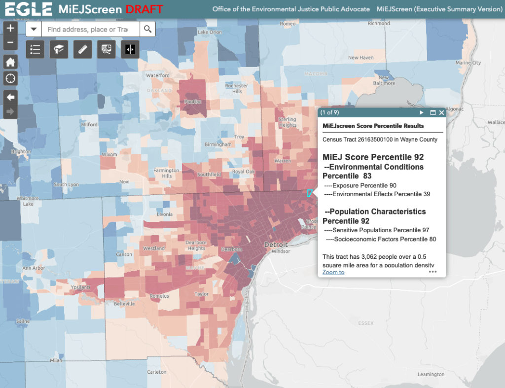
As many of these project show, Detroit is at an extreme disadvantage compared to its neighbors and compared to the rest of the state. Environmental effects, environmental exposure, sensitive populations (asthma, blood lead levels, etc.), and socioeconomic factors all are more heavily weighted in Detroit.
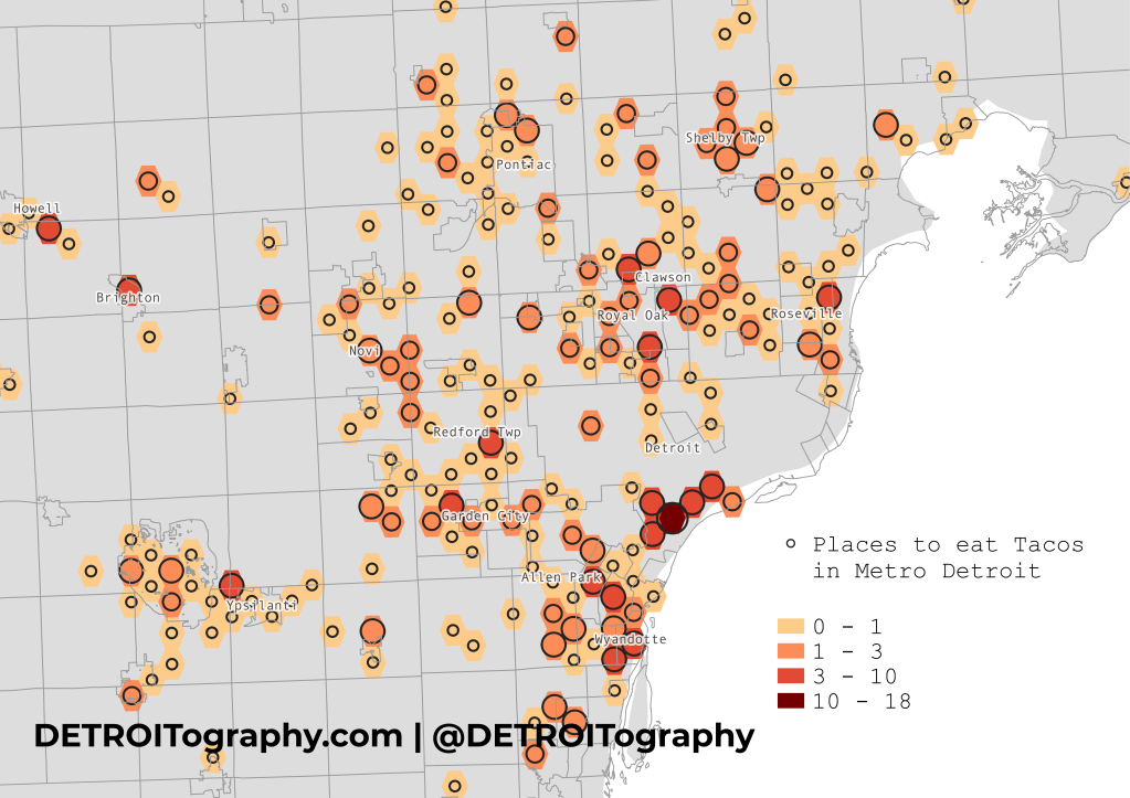
Hands down, Southwest Detroit is the absolute best, most dense, most authentic place to eat tacos.
Tacos originated from Mexico and, like many types of cultural food, has been shared across the country by peoples who have chosen to live in various communities in the US. Thankfully, Detroit is one such location. The Corktown area was well known for its growing Mexican-American population as early as the 1930s (See Mexicans of Detroit, 1979). However, recent reporting has noted the movement “Downriver” of Detroit’s Latino community, which you can see in the cluster of taco restaurants in Allen Park and Lincoln Park on the map.
This map pulls from common “point of interest” datasets, including Safegraph POI, verification using Google Places, and cross-checking with data from alltheplaces.xyz.
The map includes places with:
“Taco” or “taqueria” in the name
“Mexican” in the name
“El ” or “Los ” in the name (excluding churches and doctors offices, i.e. El Bethel and El Sayid)
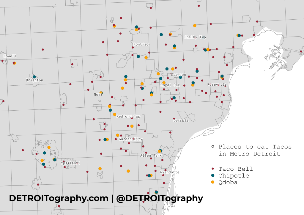
Some taco trucks made it in the list, but its likely that some did not without a fixed location. What stood out most from the data was the ubiquity of taco chains in the metro area outside of Detroit while the local, authentic tacos are best found in Southwest Detroit.
I noticed small blue plaques started popping up on light poles across the city. Many of them had dates from the early 1900s, so I wondered what the source was. There is a large effort to track and map “officer down” memorials. COVID-19 became a leading cause of death for police officers across the country during the pandemic. This site keeps a record of the locations and circumstances as well as the chronic disease causes of death of officers.
The memorials appear to cluster in the Downtown area likely due to the higher rates of crime Downtown and the historical nature of the memorials (back to 1883) showing more officers killed when the city was much smaller than it is today.
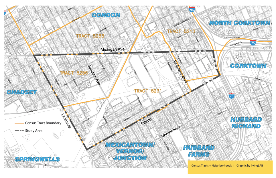
A new report from Southwest Detroit Business Association (SDBA), LISC, and Detroit Future City explores the creation of an “industrial district” in Southwest Detroit. There are a high number of industrial sites and a significant number of jobs located in the area. The goal of the study and report was to set a path towards equitable economic development.
This study is focused on the industrially zoned properties that include and surround the Clark Street Technology Park. The study area is roughly bounded by Michigan Avenue, Livernois, Vernor Highway and I-96/I-75. The industrial properties and their adjacent residential neighborhoods are primarily contained within four census tracts: 5213, 5231, 5255, and 5256 (2010 Census boundaries).
The UM Poverty Solutions team conducted an extensive mapping of internet access points and related indicators to present a comprehensive view of the “digitaldivide” in Detroit. I found the list of “internet access” sites very interesting and clearly more dense Downtown and Midtown.
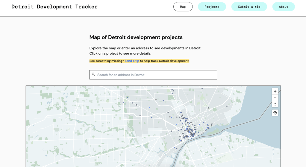
It’s hard to keep up with all the development that is happening in Detroit. Developers send out press releases all the time, buildings get tax incentives for redevelopment, City Council approves use change, Planning Commission has hearings on zoning changes – there is all too much to keep track of when it comes to “large-scale and commercial” development. The new Detroit Development Tracker from Detour Detroit seeks to do just that – with the support of the community (so be sure to send your tips!).
It’s not surprising to see the majority of development projects happening in the “Greater Downtown” area with limited development elsewhere in the city.
A new report digs into supportive loan programs in Detroit when mortgage loans are nearly impossible to secure from lenders. Upwards of 80% of home sales in Downtown and Midtown are accomplished with a mortgage, but almost everywhere else in the city the percent of sales with a mortgage are 20% or less. The Down Payment Assistance (DPA) program from MSHDA made just 3% of its loans in Detroit.
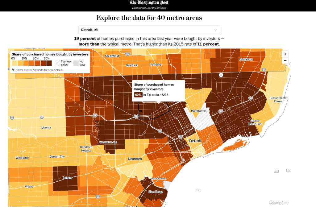
The Washington Post analyzed 2021 home sales by ZIP code in the top 40 metropolitan markets. Detroit falls within the top 10 with investors buying a high percentage of homes. There is extensive “investor” activity across the city. We’ve been tracking this issue with Property Praxis investigating speculative land buyers since 2016. This is a concerning trend that appears to have only continued during the pandemic.
From Develop Detroit CEO Sonya Mays:
For example, in 48238 (Russell Woods to Fitzgerald) investors bought 69% of homes in 2021!!! Honestly, I can’t make much sense of this – I assume that the Land Bank activities drive some portion of this outcome and I assume that overall home sales in this zip are relatively low. I was well aware that this activity was going on across Detroit, but did not anticipate this scale. I have so many questions.
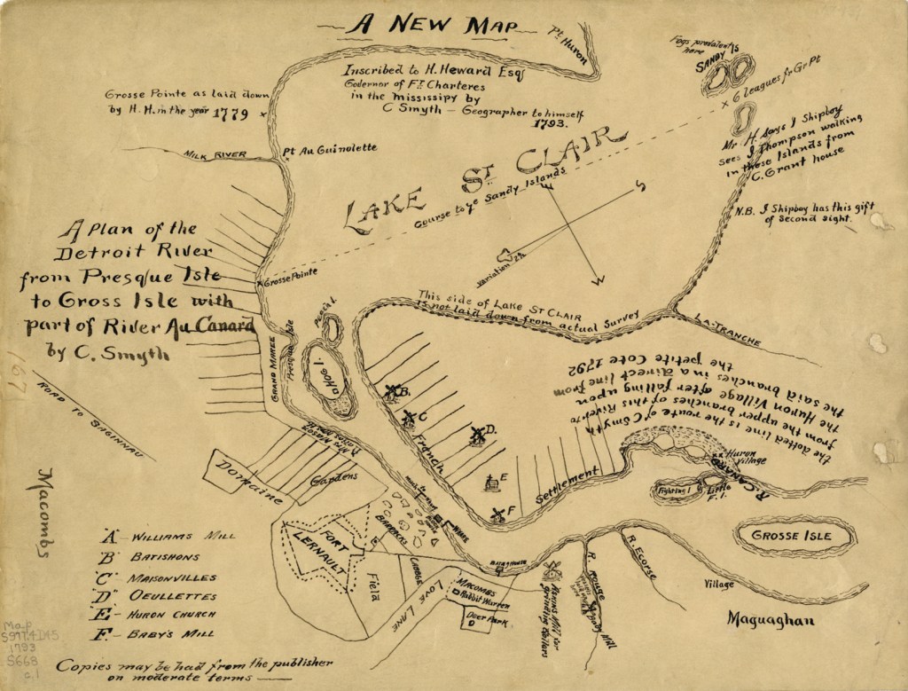
Somehow I’ve never shared this hand drawn beauty of a map from the DPL Digital Collections. The note on the map reads:
“A new map inscribed to H. Heward Esq., Governor of Ft. Charteres in the Mississipy by C. Smyth, geographer to himself, 1793. A plan of the Detroit River from Presque Isle to Gross Isle [sic] with part of River au Canard by C. Smyth.”
Fort Lernault is the most prominent Detroit point of interest. Hog Island and the Grand Marais (spelled Grand Maree on the map) are accompanied by the long “gardens” that we know well as ribbon farms of settler Detroit. In what is Southwest Detroit today there is an interesting assortment of places including: Macomb’s rabbit warren, deer park, and Askins Mill and Baby Mill.o
Most people probably don’t know that there is a scooter deployment dashboard because the City of Detroit tried to enforce an equitable distribution of scooters beyond Downtown. Needless to say scooter activity is heavily focused in the Greater Greater Downtown area.
Scooter companies have flocked to Detroit unlike bikeshare where one provider has ruled the streets. There are now a total of 5 different scooter companies operating in Detroit.
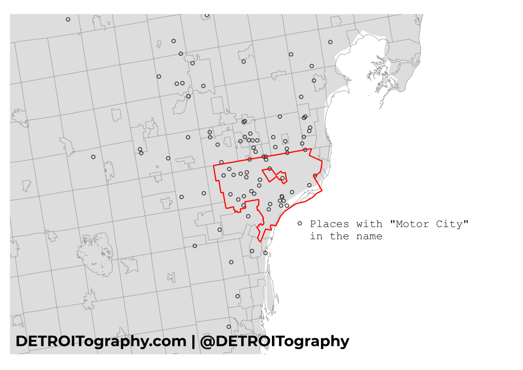
I hear this question all the time, sometimes it is a vulgarity thrown at suburban businesses using “Detroit” in their name to profit from the city. The data show that truly the majority of places and businesses using “Detroit” in their name are located within the city limits. The concentration is Downtown with widespread use in Northwest Detroit.
Data from the Places API shows that Southfield is the number one suburb using the “Detroit” name. This was the result expected from my “100 Maps of Detroit” where many national corporations locate their “Detroit office” in the Southfield Civic Center area.
Top 5 “Detroit” Suburbs
Southfield
Warren
Ferndale
Troy
Royal Oak
UPDATE 02/15/22: Based on some comments here is the “Motor City” spread
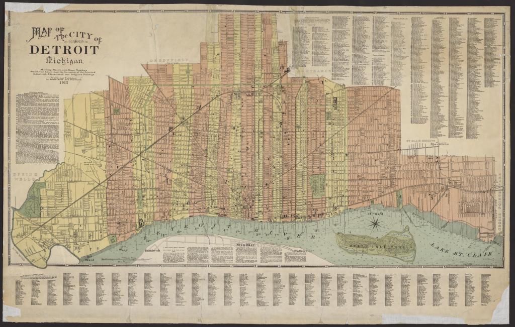
In searching for maps about street numbering, I came across this interesting map from the UM Clark Library. It’s a historical map that I hadn’t seen before and it reminded me that most old maps focused on displaying street numbers and indexes so that people could find locations and navigate the city.
There aren’t many maps from 1912 (here’s another on children’s recreation) when Detroit was quite an odd shape after stabilizing from earlier annexation activity in the early 1900s. I particularly enjoy the color scheme that is used to denote the different Wards of the city.
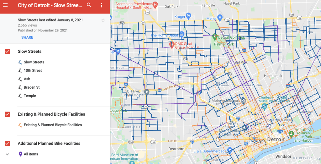
The City of Detroit has been slowly attempting to tackle the high rate of pedestrian deaths by motor vehicles. The speed humps have been a big part of reducing speeding along with road diets on major arterial roadways like Gratiot and Grand River in collaboration with MDOT. “Slow Streets” are the next major effort:
“A slow street is a residential street with some form of traffic calming, such as speed cushions and signage to help you access key destinations such as parks and schools within your neighborhood.”
Contact
Submit a map or just get in touch. Thanks for following!