Map: Detroit COVID-19 Cases versus Vaccination Rates 2021

COVID-19 has laid bare all of the systemic health inequities across the country, but also very specifically in Detroit.

Local public health systems including governmental health departments and health care providers are key to building public trust on an every day basis. In places where the local public health system has broken down, it is no surprise to see low levels of trust and low rates of vaccine uptake.

Detroit is likely an extreme example where the city’s largest health system almost shuttered its doors in the early 2000s before getting a monetary grant from the State government. Detroit has operated its own city health department on par with a county government since the 1970s, but decided to push provision of health services to an unproven non-profit in 2012 after a series of federal investigations that began in 2010.

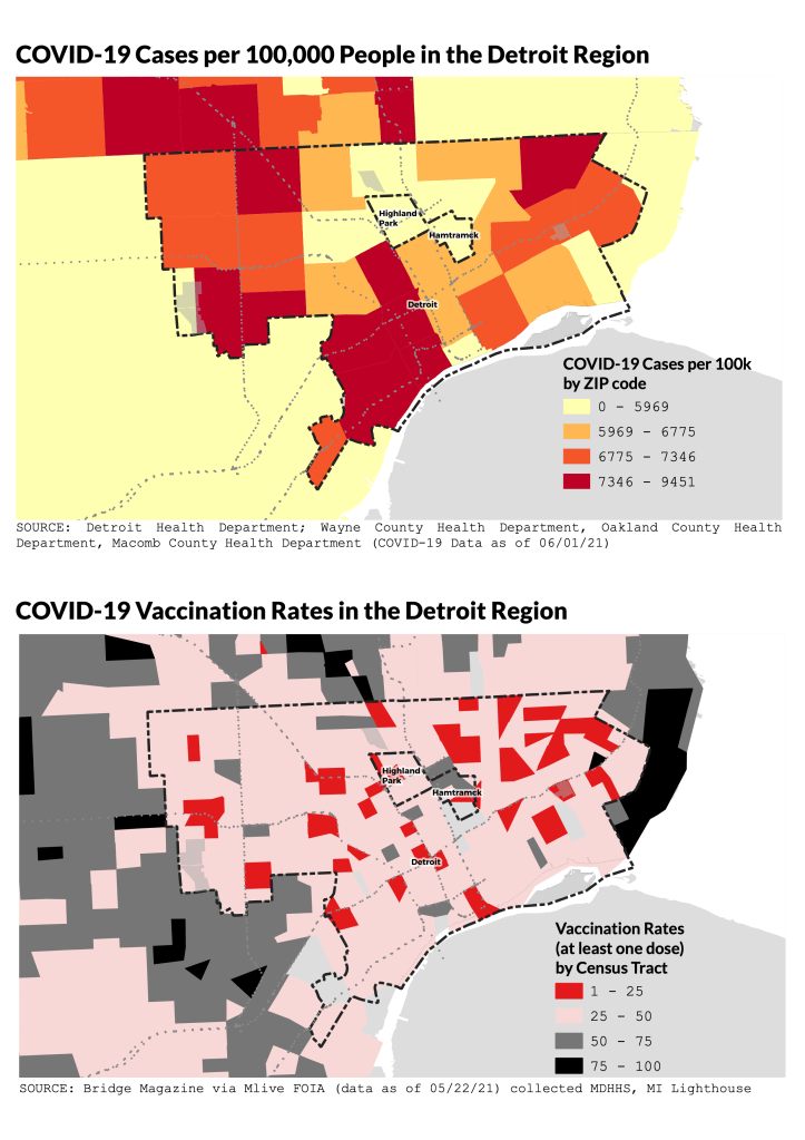
The current health department was only just relaunched in 2015 and at best could be described as a “startup.” Detroit’s other hurdle is that roughly 70% of the population lives in a medically underserved area and almost 20% haven’t seen a doctor in over a year (MiBRFSS 2017-2019). COVID-19 vaccination rates remain low in Detroit at around 30%, however mass vaccination sites, mobile health vans, and tent style health clinics are not an ideal entry point to build trust in a local public health system that hasn’t been there for residents in over a decade. The issue in Detroit is not vaccine hesitancy, but the absence of a local public health system that will serve people well on a regular basis. 

Map: Drawing Detroit with M. Saffell Gardner

This hand drawn map by M. Saffell Gardner is a part of a series of hand drawn maps in a Volume 2 of Detroit Research Journal. The map is part of the “Drawing Detroit” series which aims to collect personal and hand drawn maps of Detroit.

Check out the different hand drawn and hand maps that we’ve collected over the years.

Map: Coffee Shops and COVID-19 in 2021

Detroit has 82 coffee shops. Since 2019, 16 new shops opened and 13 closed. During the COVID-19 pandemic, 11 coffee shops temporarily closed and 8 have reopened, at least for takeout.

Since 2015 Detroit has had a net gain of 28 coffee shops. A number of new community coffee shops launched during the pandemic including Black Coffee in the Northend, Milwaukee Caffe in Milwaukee Junction, The Congregation, Gathering Co., Public Square in Grandmont-Rosedale, Morningside Cafe in Morningside, Yellow Light in Jefferson Chalmers, and Cafe Alto in the former New Order Coffee spot in Midtown.

New Order Coffee (in former Ye Olde Butcher Shoppe space) abandoned the city to focus on their Royal Oak location and tears were shed when Avalon Biscuit Bar closed permanently (at the former Cafe con Leche spot).

After Coffee and (____) closed in Jefferson-Chalmers it seemed that beyond West Village, the Eastside would be uncaffeinated. Now in 2021, there are so many new options including a border line Starbucks. The Eastside and the “Heart of Detroit” and Northend seem to be the current hot zones for coffee. Downtown and Midtown are already so dense with coffee that perhaps development is making its way northward. Is New Center getting leap frogged? Coffee has had a hard time sticking with Cafe con Leche closing before the Avalon Biscuit Bar at the same spot.

Map: Tree Equity in Detroit

Detroit needs a lot more trees. It’s no mystery that Detroit has been hit by deindustrialization and population loss on top of Dutch Elm disease leaving many trees either dead, dying, or left uncared for along city streets. I’ve previously looked at tree canopy disparities and posted about the dangers of heat islands and the absence of green space in a city.

Recent City of Detroit efforts to increase street trees are doing a little, but replanting an urban forest is no small feat. The economic, climate, and public health benefits would be immense if Detroit can add more trees in neighborhoods that need them.

Map: Digitized Indigenous Trails in Detroit 1931

In honor of Indigenous Peoples’ Day, I wanted to share this map that I’ve been thinking about for some time. These trails were digitized and georeferenced from the 1931 Archaeological Atlas of Michigan.

Detroit’s street design with its hub-and-spoke pattern Downtown are often attributed to Western men with grand idea after Detroit’s “Great Fire of 1805.” The story goes that they imagined Detroit in the image of Paris or Washington D.C. – but in reality Detroit’s unique radial streets come from the pathways created by indigenous peoples living on this land before any Frenchman arrived.

Map: Drawing Detroit with Alex B. Hill

I made this hand drawn map as part of the “Drawing Detroit” series which aims to collect personal and hand drawn maps of Detroit. This map was published in Volume 2 of Detroit Research Journal.

In 2015, I was thinking introspectively about the spaces that I inhabited in Detroit especially as it related to race. As a young, white man I had lived in a handful of “islands of privilege” in the city – and this map was my exploration of those islands and their disconnect to the larger city.

Check out the different hand drawn and hand maps that we’ve collected over the years.

Map: Detroit’s Poletown Community 1989

The federal government’s General Accounting Office (GAO) produced a report on Detroit’s “Central Industrial Park” for what would become known as the Poletown Plant or the Dodge-Hamtramck Assembly, Dodge Main, and now referred to as Factory Zero.

The “Poletown Community” was defined in this report as all of the City of Hamtramck and a significant section of Detroit south of Hamtramck. The project eventually relocated 4,200 people and 1,400 homes. The remnant of the area lives on in the “Poletown East” neighborhood area defined by the City of Detroit.

Map: Children and Library Access in Detroit 2020 – 2021

The issue of open library branches has been on-going since the COIVD-19 pandemic started. For over a year now, only 6 library branches have been open and there isn’t any expected change for Summer 2021.

I was concerned that closed Library branches meant that children wouldn’t have access over the summer let alone during the school year. I was pleasantly surprised that the branches still open largely fall within areas with high numbers of children. Notably, the Knapp branch near Hamtramck would serve an area with a significant number of children.

Libraries have been a community home base for many residents where they can read, use internet, and connect with what is happening. In a city with a significant digital divide and an overall low level of connectivity across the city (door-to-door outreach is the baseline) we have to keep our branches open and expand what they can offer.

Map: HUD owned Vacant Lots in Detroit 1974

One of the few maps (maybe the only map) of vacant land in the 1970s in Detroit came from the Housing and Urban Development’s (HUD) assessment of their inability to maintain their growing inventory of properties and land. This map was produced by the Detroit News for a series of stories on HUD’s Detroit inventory.

This map shows there were 4,763 vacant lots owned by HUD which gives a rough sense of where there may have been more Farm-a-Lot programming.

Map: Joe Louis Greenway loop in Detroit 2021

The ground has been broken! The multi-year effort to both develop and secure land to make the Joe Louis Greenway (JLG) a reality is on the move. The JLG 27.5 mile loop hopes to be completed within 5 years and in the process connect neighborhoods across Detroit as well as Highland Park and Hamtramck.

Read the full framework plan HERE

Map: Drawing Detroit with Clara DeGalan

This hand drawn map by Clara DeGalan is a part of a series of hand drawn maps in a Volume 2 of Detroit Research Journal. The map is part of the “Drawing Detroit” series which aims to collect personal and hand drawn maps of Detroit.

Check out the different hand drawn and hand maps that we’ve collected over the years.

Map: Detroit – Windsor Transportation and Terminal Facilities 1943

There was no Detroit Metropolitan Wayne County Airport (DTW) in 1943. That would take another 6 years for the existing Wayne County airport to add three more runways and pull air traffic away from Detroit City Airport. This map comes from the “south Detroit” side of things. Windsor was exploring a new international airport that would take up nearly half the city.

Map: Drawing Detroit with ‘jide Aje

This hand drawn map by ‘jide Aje is a part of a series of hand drawn maps in a Volume 2 of Detroit Research Journal. The map is part of the “Drawing Detroit” series which aims to collect personal and hand drawn maps of Detroit.

Check out the different hand drawn and hand maps that we’ve collected over the years.

Map: Detroit M1 Light Rail 1979

The M1 Rail project has been in the urban mass transit imagination since at least 1979. This map comes from a joint report led by the Southeastern Michigan Transportation Authority (SEMTA), from which SMART would form in future years, and the USDOT Urban Mass Transportation Administration (UMTA).

The report also explored the Downtown People Mover (DPM) option, which seems to be the only project option that was funded.

I was fascinated to see that this plan called for the M1 light rail to be subsurface (subway) from Jefferson Ave to Grand Boulevard and then aerial, like the People Mover, from Grand Blvd. to McNichols before functioning at-grade at the street level.

Maps at Home with PG Watkins and a recreated map of Detroit’s Black Bottom

What is your map at home (title, year, etc.)

This is a digitally recreated map of the Black Bottom neighborhood as it was in 1951 by Emily Kutil, the creator of Black Bottom Street View. The map was compiled in 2018 from Sanborn Fire Insurance Maps.

Where did you find/acquire the map?

Black Bottom Archives, an organization I am the director & co-founder of, printed these maps in a limited edition way as a way to fundraise.

What made you hang it on your wall? What stood out to you? What details do you enjoy about the map?

Black Bottom is such an important part of my work and I love having the reminder of this significant neighborhood in my home and seeing it everyday. I got a custom framing job done at Eric’s I’ve Been Framed on Livernois and he helped me find a frame that matched the tones of the map and made it look so lovely I couldn’t help but hang it up! The details I love are that there are a few important community spaces that are marked on the map. And, because it was made from fire insurance maps, you can also see what kind of materials the different structures were made of, which tells a bit of its own story in the conditions of the neighborhood at the time.

What in your background has drawn you to maps?

I am a lover of history and maps tell so many stories. With Black Bottom being such a focal point of my work, I am always drawn to maps that seek to define the boundaries of the neighborhood. From the elders I’ve talked to, I know that how far east and west and north the neighborhood actually went is something that there are a variety of opinions about. I know if different people were to have created this map and it would have looked differently, and that is so compelling to me. Maps have always been a way of understanding someone’s perspective and connection to the place they’re documenting.

Map: Potential Sites in Detroit for Tree Buffers

Vegetative and tree buffers have been discussed as methods to reduce climate and air pollution impacts. Much of the effect requires full growth trees and multi-level vegetation.

The City of Detroit launched a 10,000 street trees effort a few years ago and had some difficulty with residential adoption of street trees.

As a City government, Detroit has the opportunity to show it is a “good neighbor” and plant street trees on properties owned by the city, city departmental properties, and parks. There are over 900 acres of land owned or controlled by the City government within 250 feet of expressways that could be utilized for tree buffer style plantings.

Map: Detroit Urban Heat Islands 2020

This beautiful map is part of a USDA report that includes outcomes from the Heat Watch Detroit program during summer of 2020.

The average annual temperatures of UHI areas in Detroit are 1.8°F to 5.4°F warmer than adjacent areas, ranging from 70°F to 85°F (Gregg et al., 2012 & Heat in the City, 2020). CAPA Strategies conducted a Heat Watch in Detroit, providing maps of temperature distributions throughout the city on August 8, 2020 for the morning, afternoon, and evening (Figure 1.9). This study demonstrates where in the city there are warmer and cooler pockets, which are often dependent on the qualities of the land as well as its use.

Pictorial Map of Detroit 1934

Artist William Ogg Fitzgerald drew this pictorial map in 1934 for the Chrysler Corporation.

It presents an interesting amalgamation of the breadth of the automotive industry and specifically the Chrysler plants are in red as well as historical events in Detroit and Windsor.

It’s important to take this map’s historical accuracy with a grain of salt, but it has been presented beautifully with vibrant colors.

Maps at Home with Jason Hall and his massive Detroit Wall Map

What is your map at home (title, year, etc.)

I’m not actually sure. It was just a map that got blown up to be the backdrop at an event. I think they just found a map with “Detroit” in big letters, like it is behind me. It’s about 8ft long by 5ft tall and printed on corrugated foam board. It’s literally the centerpiece of my living room.

It’s actually three, maybe four, pieces. I gave one piece that covered the Eastside to a friend living there and another piece to friend in Southwest Detroit. I kept the piece that meant a lot to me.

Where did you find/acquire the map?

This was given to me by the Display Group. I was co-chair of American Heart Association’s charity ball and it was part of the decor. I asked what they were going to do with it after the event and they said they’d probably just throw it away. I could fit three pieces of the map in my car after the event.

What made you hang it on your wall? What stood out to you? What details do you enjoy about the map?

Where I grew up is on this map and where I lived (at that time) was on the map too. It was a sign.

And I do love maps. When I look at this map though I don’t see lines, I see memories. I see railroad tracks. I’ve been down every street on this map.

So, I founded the world’s largest weekly bike ride, called Slow Roll. I made the Slow Roll maps for 10 years. There have only been a few times when we got in trouble for what we do. In Hamtramck we caused a major issue with hundreds of people’s cars getting ticketed or broken into. The Hamtramck mayor even wrote about it after. So there is a Slow Roll sticker on the city because I say that’s the closest I’ll ever get again to Hamtramck because it’s too much work.

What in your background has drawn you to maps?

I love maps. Growing up my parents couldn’t afford for us to travel, so maps were my way to travel.

When I did the commercial with Apple, I had never traveled and that opened so many doors. After traveling more places, maps became something different to me. I never realized how important it was to travel and experience other places. It’s mandatory. If you don’t see the world then you haven’t been shaped by global theories and philosophies.

Now when i look at a map instead of admiration, its motivation to go and see that place.

Map: Detroit’s Black-owned Food System

The repeated and compound impact of structural racism on Detroit’s food system couldn’t be more obvious than the need for a Black Farmer Land Fund, a Black Restaurant Week, and crowd-funding efforts for Black-owned grocery stores in the Blackest city in the US. These are just a few recent concerted efforts to change the status quo, but its important to note that this is NOT everything that is Black-owned in Detroit’s food system. The additional gray dots are food businesses catalogued by The Black Bottom Archives (add any missing businesses to their directory).

The Black Farmer Land Fund launched to address the racial disparity of land access in urban agriculture in Detroit. The cumbersome process of working with the Land Bank was limiting the number of Black participants that could access land for agricultural uses. D-Town Farm run by the Detroit Black Community Food Security Network (DBCFSN) and Oakland Avenue Urban Farm are the two best known Black-owned urban agriculture operations.

Detroit Black Restaurant Week launched in 2017 and the founder, Kwaku Osei-Bonsu, received racist diatribes and death threats. The week featuring Black restaurants is now in it’s 6th year with 30 participating restaurants. COVID-19 has hit Black-owned restaurants hard with both ima and Detroit Vegan Soul closing one of their two locations, The Block closing permanently, and others struggling to hold on.

The last Black-owned grocery store in Detroit closed in 2014. James Hooks ran Metro Foodland on Grand River Ave. right up until a Meijer Superstore became his neighbor. The financial case for opening a grocery store is tough, but trying to convince a lender to invest in a Black-owned business seems even harder. Two current Black-owned grocery store efforts are relying on memberships and crowdsourcing to finance the opening. The Detroit Food Commons and the Detroit People’s Food Co-op closed on their land deal and are moving forward. The Neighborhood Grocery has secured a small store building and nearby land to grow produce.