Map: Social Connectedness in Detroit 2016

Screen Shot 2018-09-19 at 4.48.49 PM

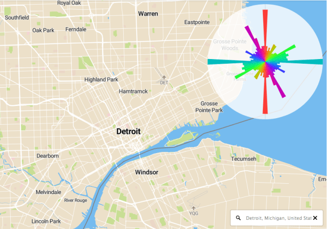
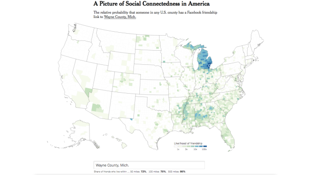
Detroit and Wayne County’s “social connectedness” show strong ties within the Mitten as well as some peripheral connections to the south, Mississippi, Alabama, and Georgia. The southern ties are most likely related to the Great Migration of African Americans to northern industrial cities.

More from NYTimes:

This map shows an index of connectedness, created using friendship links between pairs of anonymous Facebook users from a snapshot of the platform in April 2016. The researchers aggregated the links at the county level, so neither the Times nor other academics working with the data can identify individual users within it, or how many Facebook users live in each county. Because counties with more people invariably have links to more places, this map rescales the index to account for differences in population.

Workshop: Data, Mapping, and Research Justice


I’ll be teaching my workshop on data and mapping again this October 2018 with Co.Open/Allied Media Projects.

During the 4-week course we will journey through the entire mapping process; from paper survey to digital database, basic map visualizations, and finally analysis. We will be working with free and open source software (QGIS, LibreOffice, Inkscape, etc.).

Check out some of the past course projects:

Monday nights in October (4 weeks long) 6-9pm

Sign up! HERE


Map: Eat Vegan in Detroit

Screen Shot 2018-09-17 at 8.29.34 AM.png

Esther Loopstra created this beautiful hand drawn illustration map after visiting Detroit for a conference. She excellently highlights: Detroit Vegan Soul, Russel Street Deli, Dilla’s Delights, Mudgie’s Deli, Seva Detroit, Cass Cafe, Ima, Pie Sci, and Trinosophes.


Map: Detroit Strategic Plan for Transportation 2.0

Screen Shot 2018-09-09 at 11.03.57 AM.png

This map comes from the new “Detroit Strategic Plan for Transportation” representing DDOT 2.0, a high-frequency transit system that serves 60% of Detroiters.

Check out the full plan HERE

Possibly the most exciting elements of the plan are for reductions in parking and removal of requirements for parking at new developments when located near transit.

Map: Racial Steering in Detroit Housing 2003-2005

Screen Shot 2018-08-27 at 9.10.48 AM

In 2007, the National Fair Housing Alliance (NFHA) filed a lawsuit against Century 21 Real Estate LLC and it’s franchisee, Centry 21 Town and Country, in federal court. During the 2003-2005 period, NFHA tested 14 real estate agents of which 9 engaged in “racial steering” encouraging whites to seek homes in predominantly white neighborhoods such as the Grosse Pointes and blacks to seek homes in predominantly black neighborhoods such as East English Village.

Detroit Events for City and Map Enthusiasts

pxd_home

Gehl Public x Design

WHEN: September 23 – 25

Together, we’ll dive into issues related to inclusion and equity in public life—the everyday social life of parks, plazas, sidewalks, and other spaces between buildings—and share approaches to planning, designing, and sustaining quality public spaces. Last year we developed an agenda for action. This year, we take it further—but we need your ideas.

ATTENDANCE:

  • Early Bird Student – $195
  • Early Bird Gov/Nonprofit – $295
  • Early Bird Participant – $450
  • Student – $275
  • Gov/Nonprofit – $375
  • Participant – $525

miotke_logo

State of the Map US

(*Note: Detroit is not the entire Lower Peninsula of the State of Michigan)

WHEN: October 5 – 7

Join the OpenStreetMap community at State of the Map US in Detroit, Michigan. Connect with other mappers, businesses, government agencies, and non profits, all collaborating around the free and editable map of the world. Share your vision for the project, learn how to work with OpenStreetMap data, and hack on the latest mapping improvements.

ATTENDANCE:

  • Early Bird Student – $25
  • Early Bird Individual – $100
  • Individual – $200

Screen Shot 2018-08-10 at 9.20.24 AM.png

CityLab 2018

WHEN: October 28 – 30

What can city leaders do to fuel innovation that improves quality of life for all? What can rising cities learn from the challenges faced by peers? At CityLab 2018, The Atlantic, The Aspen Institute and Bloomberg Philanthropies will convene the world’s city and community leaders to consider a new narrative worthy of the many global cities whose history may weigh heavy, but whose future holds the promise of a fresh page.

ATTENDANCE: Invitation only

Map: Detroit Streets and Real Estate 1872

silas-farmer-1872

This street map of Detroit was created by city surveyor, Eugene Robinson and published by the Silas Farmer Company (31 Monroe Ave, corner of Farmer St.)

An additional ink stamp on the map reads:

“Waterman’s Real Estate Exchange. First-class Private Residences, Vacant Lots on the Best Streets. Business Property for sale by WM. J. WATERMAN, opposite the Post Office.”

Maps have been such an impactful tool for real estate and land developers for over a century.

Map: Hastings-Oakland Expressway in Detroit

Oakland-Hastings-Expressway

This map of the proposed location of what we now know as Interstate 75 comes from the Detroit Public Library Digital Collections. I had heard plenty about the expressway razing Paradise Valley and the center of Detroit’s black community along Hastings Street, but never heard the expressway referred to as Hastings-Oakland.

Map of Hastings-Oakland Expressway in Detroit; proposed general location plan Jefferson Ave. to Alexandrine. Label on mount: “Hastings-Oakland Expressway, River to Mack.” Printed on mount: “Produced by Florez Incorporated, Detroit, Mich.”

Map: Polar Histogram of Detroit Roadways

Screen Shot 2018-07-19 at 11.24.41 PM

Mapbox engineer, Vladimir Agafonkin, decided to make the polar histogram of roadways interactive with this map inspired by the work of Seth Kadish and Geoff Boeing. Incredible method to summarize the development patterns of cities.

Detroit from City Street Orientations by Geoff Boeing


Map: Downtown Detroit Civic Center 1878

civic-center-1878

File this under the “unbuilt Detroit” category, (traced by H.F.J.) from E. H. Bennet architects in Chicago. North of Campus Martius, this “civic center,” located at what is now Grand Circus Park, would have functioned as a true Downtown hub for government, entertainment, and city life.

Map: The Native Land of Detroit

Screen Shot 2018-07-19 at 11.18.49 PM

Just a reminder that the land you may or may not own or occupy in Detroit was never anyone’s to take, divide, or sell. We are all on native land. In Detroit, that means the land of:

  • Anishinabe
  • Haudenosauneega
  • Miami
  • Odawa
  • Peoria
  • Potawatomi

Understand more at native-land.ca

Map: Detroit Eastern Market’s Regional Foodshed

EMC-foodshed

Detroit’s Eastern Market is known as a regional food hub, where producers and consumers meet to connect the food system supply chain. I was curious as to the extent of Eastern Market’s ability to aggregate and distribute fresh produce in the region and decided to map growers and farmers from the list of weekly Saturday market vendors.

While Eastern Market’s reach is statewide even into Ohio and Ontario, the vast majority of food hub participants are within 40 miles of the market. There are a very small number of growers from within the City of Detroit and the majority come from Macomb and St. Clair counties to the Northeast. These areas within the 40 mile range are, not surprisingly, at the edge of the urban – rural transition.

EMC-foodshed-urban-rural

Map: Detroit and Grosse Pointe in 1904

Screen Shot 2018-07-18 at 8.35.08 AM

This map is from the “Detailed official atlas of Wayne County, Michigan” from 1904 “compiled and drawn from Authentic records and private surveys by W.C. Sauer, C.E.

If you happened to live East of Conner Street in 1904, you were a Grosse Pointer.

Map: Detroit Rental Property Compliance 2018

Screen Shot 2018-02-28 at 10.31.14 AM

In 2018, the City of Detroit launched a massive effort to determine a baseline for all rental properties and their levels of compliance within the city. This year will cover 5 zip codes, with others (total of 31 zip codes) being assessed in following years up until 2020.

“City of Detroit building inspectors will begin their efforts on Feb. 1 to identify every rental property in Detroit and have them registered in compliance with city codes. The goal of the new ordinance is to ensure that every renter in Detroit is living in a property that is safe and up to code by the middle of 2020.”

Detroit Works Project City Map 2012

dwp_map_2012.png

This map was used on the “Building from Strength” section on Mayor Dave Bing’s “Detroit Works Project” that ultimately became Detroit Future City. The map was to anchor the idea that Detroit has plenty of assets to build from rather than focus on the negatives.

There’s plenty to work with. Detroit is the city that put the world on wheels. A city with rich cultural heritage, ethnic tradition and a legacy of innovation. The middle class was born here. We built the Arsenal of Democracy and the first expressway to help expand it. It’s a city where bold ideas have become very real and set the example for the world.

It’s time. Time to think big.

It’s already happening. Gardens are springing from empty lots. A riverfront has been transformed. Business incubators are popping up, more and more. This is the moment to pull together what’s already happening and consider even bigger “what-ifs.” It’s time to work together towards something better. To once again define a path for us, and urban America. To define a future for Detroit that works. Now.

Map: Sanborn Fire Insurance Downtown Detroit 1904

sanborn-detroit-1904

Sometimes it’s just interesting to sit back and look at what used to be.

Downtown Detroit in 1904 looks nothing like it does today besides a handful of landmark buildings, such as the County Building. Many of the parks remain the same Downtown, however West Park is now where the Rosa Parks Transit Center resides and Campus Martius has expanded considerably.

Map: Ford’s New Corktown

636650292835213020-Corktown

The well-loved and oft-mentioned, oldest, and “revitalized” neighborhood of Corktown is seeing its own kind of re-revitalization with the arrival of the Ford Motor Company. This depiction shows just a few of the well known buildings that Ford has bought in the neighborhood, yet there are reportedly nearly 50 properties tied to Ford that have been purchased recently.

This presents an important reminder that even with Detroit neighborhoods that seem to be all that, there is still countless opportunities to do more. Besides reminding us of the potential for a large corporation to move into a neighborhood, this should also remind us that there are countless opportunities to do development differently, better, and more equitably.