
Have you visited the Spirit of Detroit plaza recently?
Now there is an awesome abstract map painted on the ground by Summer in the City youth.
Have you visited the Spirit of Detroit plaza recently?
Now there is an awesome abstract map painted on the ground by Summer in the City youth.
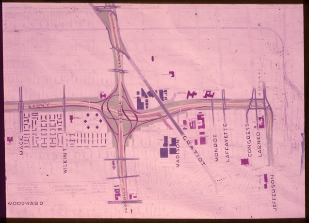
This map of the proposed location of what we now know as Interstate 75 comes from the Detroit Public Library Digital Collections. I had heard plenty about the expressway razing Paradise Valley and the center of Detroit’s black community along Hastings Street, but never heard the expressway referred to as Hastings-Oakland.
Map of Hastings-Oakland Expressway in Detroit; proposed general location plan Jefferson Ave. to Alexandrine. Label on mount: “Hastings-Oakland Expressway, River to Mack.” Printed on mount: “Produced by Florez Incorporated, Detroit, Mich.”
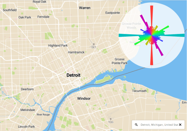
Mapbox engineer, Vladimir Agafonkin, decided to make the polar histogram of roadways interactive with this map inspired by the work of Seth Kadish and Geoff Boeing. Incredible method to summarize the development patterns of cities.

Detroit from City Street Orientations by Geoff Boeing
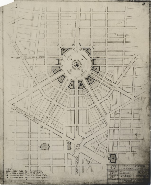
File this under the “unbuilt Detroit” category, (traced by H.F.J.) from E. H. Bennet architects in Chicago. North of Campus Martius, this “civic center,” located at what is now Grand Circus Park, would have functioned as a true Downtown hub for government, entertainment, and city life.
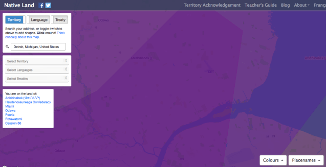
Just a reminder that the land you may or may not own or occupy in Detroit was never anyone’s to take, divide, or sell. We are all on native land. In Detroit, that means the land of:
Understand more at native-land.ca
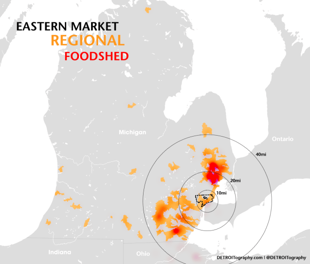
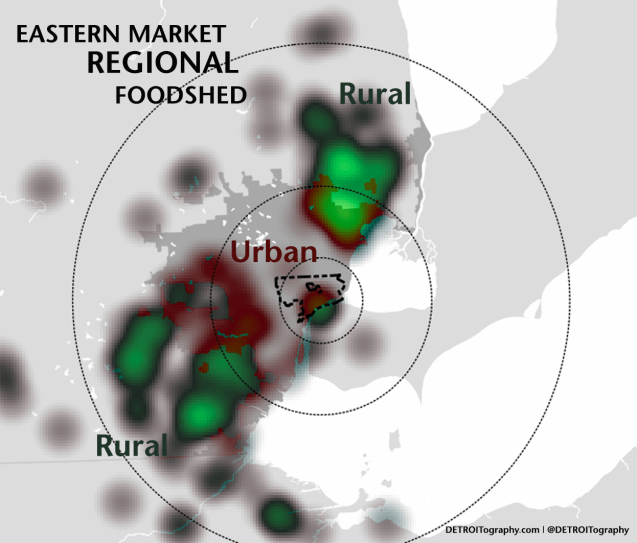
Detroit’s Eastern Market is known as a regional food hub, where producers and consumers meet to connect the food system supply chain. I was curious as to the extent of Eastern Market’s ability to aggregate and distribute fresh produce in the region and decided to map growers and farmers from the list of weekly Saturday market vendors.
While Eastern Market’s reach is statewide even into Ohio and Ontario, the vast majority of food hub participants are within 40 miles of the market. There are a very small number of growers from within the City of Detroit and the majority come from Macomb and St. Clair counties to the Northeast. These areas within the 40 mile range are, not surprisingly, at the edge of the urban – rural transition.
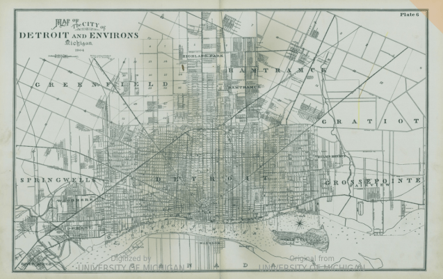
This map is from the “Detailed official atlas of Wayne County, Michigan” from 1904 “compiled and drawn from Authentic records and private surveys by W.C. Sauer, C.E.
If you happened to live East of Conner Street in 1904, you were a Grosse Pointer.
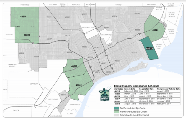
In 2018, the City of Detroit launched a massive effort to determine a baseline for all rental properties and their levels of compliance within the city. This year will cover 5 zip codes, with others (total of 31 zip codes) being assessed in following years up until 2020.
“City of Detroit building inspectors will begin their efforts on Feb. 1 to identify every rental property in Detroit and have them registered in compliance with city codes. The goal of the new ordinance is to ensure that every renter in Detroit is living in a property that is safe and up to code by the middle of 2020.”
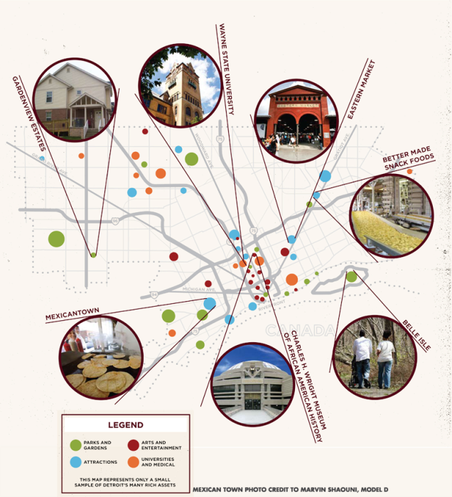
This map was used on the “Building from Strength” section on Mayor Dave Bing’s “Detroit Works Project” that ultimately became Detroit Future City. The map was to anchor the idea that Detroit has plenty of assets to build from rather than focus on the negatives.
There’s plenty to work with. Detroit is the city that put the world on wheels. A city with rich cultural heritage, ethnic tradition and a legacy of innovation. The middle class was born here. We built the Arsenal of Democracy and the first expressway to help expand it. It’s a city where bold ideas have become very real and set the example for the world.
It’s time. Time to think big.
It’s already happening. Gardens are springing from empty lots. A riverfront has been transformed. Business incubators are popping up, more and more. This is the moment to pull together what’s already happening and consider even bigger “what-ifs.” It’s time to work together towards something better. To once again define a path for us, and urban America. To define a future for Detroit that works. Now.
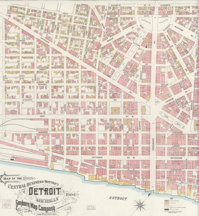
Sometimes it’s just interesting to sit back and look at what used to be.
Downtown Detroit in 1904 looks nothing like it does today besides a handful of landmark buildings, such as the County Building. Many of the parks remain the same Downtown, however West Park is now where the Rosa Parks Transit Center resides and Campus Martius has expanded considerably.
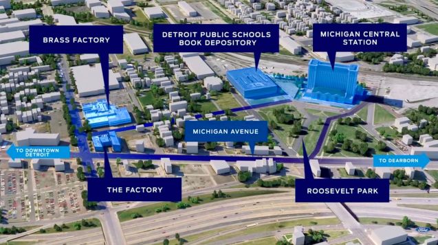
The well-loved and oft-mentioned, oldest, and “revitalized” neighborhood of Corktown is seeing its own kind of re-revitalization with the arrival of the Ford Motor Company. This depiction shows just a few of the well known buildings that Ford has bought in the neighborhood, yet there are reportedly nearly 50 properties tied to Ford that have been purchased recently.
This presents an important reminder that even with Detroit neighborhoods that seem to be all that, there is still countless opportunities to do more. Besides reminding us of the potential for a large corporation to move into a neighborhood, this should also remind us that there are countless opportunities to do development differently, better, and more equitably.
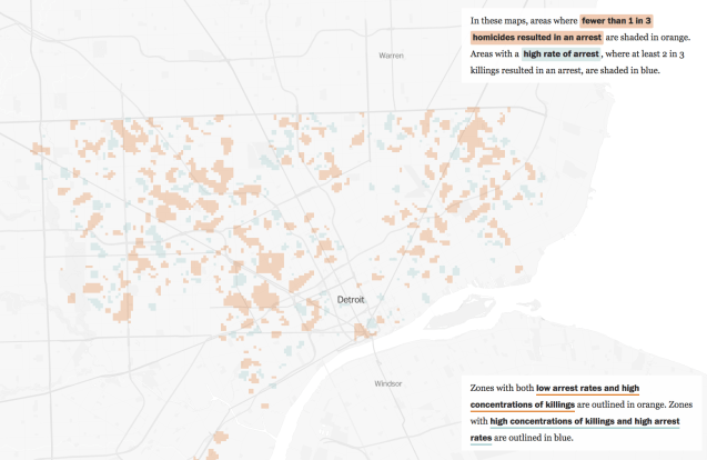
The Washington Post looked at 2,519 homicides in Detroit between 2010 and 2017 to find areas of high and low arrest rates related to homicides over the 8 year period. Detroit’s overall rate, based on the data, is 59% of homicides without an arrest while the average of the 50 cities they examined was 51%.
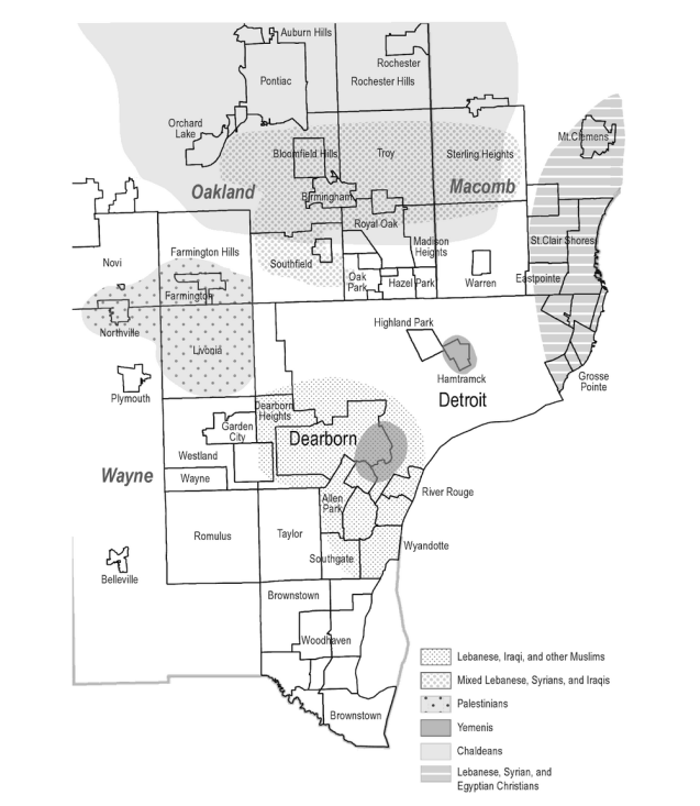
This map (without data sources or references) is featured in the book Arab Detroit 9/11: Life in the Terror Decade by Nabeel Abraham, Sally Howell, and Andrew Shryock. It’s unclear what year this represents or the source of information. Based on the chapter I assume the data comes from the “Detroit Arab American Study” (DAAS) in 2003.
“Although Arabs can be found throughout metropolitan Detroit, there are tow areas that contain the major concentrations of people of Middle Eastern descent. Each area contains about half of Arab Detroit’s population and includes a band running from east to west. One area runs across Wayne County, and the other lies in the suburbs north of Detroit in Oakland and Macomb counties. The first area is centered in the city of Dearborn, which borders the western edge of Detroit and, with one-third of its population classified as Arab (2005 ACS), is often considered to be the largest concentration of Arabs in the United States. This is the historic home of most Lebanese Muslims and more recently includes Yemeni, Palestinian, and Iraqi Muslims. The area extends eastward from Dearborn into the west side of Detroit, includes portions of Downriver to the south, and, moves across through Dearborn Heights into Wayne COunty’s western suburbs. […]
The second area lies mostly in the suburbs north of Detroit, in Oakland and Macomb counties, and is home to the Iraqi Christian population, the Syrian population, the Lebanese Christian population, and a mix of other, largely professional Arab Americans. As Dearborn has historically been the entry point for Lebanese Muslims, the initial area for newly arriving Chaldeans has been a cluster of blocks surrounding Seven Mile Road in Detroit, now called Chaldean Town. The area still houses a number of Chaldean-owned businesses and a small population of Chaldean immigrants, but the vast majority of Iraqi Christians have resettled in Southfield, Oak Park, West Bloomfield, Troy, and other suburbs, especially Sterling Heights, home to the nations largest concentration of Chaldeans.”

Matthew Desmond’s Eviction Lab examined eviction rates and poverty rates by census tract in Detroit. Around 2009, evictions were more prominent in Downtown areas with more high-rise apartments, but now it seems to have followed population movement to outer neighborhoods.
Exactly. One in twenty renter families were evicted in Detroit last year, or roughly 45 people a day. Here is a map of evictions in Detroit by poverty rates. pic.twitter.com/eQL3FaouJj
— Matthew Desmond (@just_shelter) April 30, 2018

The Detroit Greenways Coalition wants to “Envision Detroit as the Greenways Capital” of the world.
Fifty years may seem like a long time away, but with the rapidly increasing development of bicycle infrastructure across Detroit we need to set the table for the future. This report provides ideas and designs that can be incorporated into today’s projects such as the Inner Circle Greenway and the protected bike lane network. An important role of the Detroit Greenway Coalition is to be the keeper and advocate for this long-term vision.
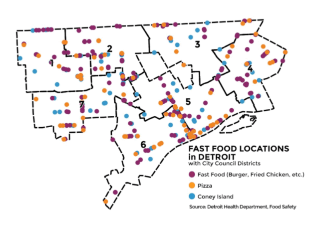 Detroit’s #2 food industry by revenue is fast food. Detroit has local chains on top of national brands. We are home to and/or birthplace of 5 different pizza companies (Little Caesar’s, Domino’s, Buddy’s, Papa’s, Happy’s). Coney Island may not completely fit into the fast food category, but accounts for a high amount of carryout food in Detroit and gets it’s own special category.
What this map doesn’t show are all the other non-chain fast casual and carryout locations in Detroit.
Read more in the full 2017 Detroit Food Metrics Report here.

This transit fantasy map comes from Mike Weiss who modeled it after the Chicago “L.” Although Detroit had scrapped plans for a subway, the rapid transit planners generally recommended an elevated rail like Chicago’s based on Detroit’s size and dispersed population.
“By using a population density map, I mapped corridors to connect the highest density areas and areas where the lack of density could spur development. Then, using my knowledge of rail transit planning, I planned routes that could operate efficiently end-to-end and where connections between them made the most sense.”
HT @DailyDetroit
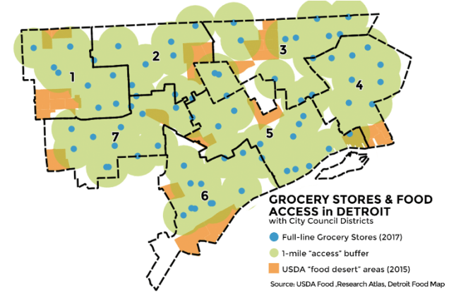
I had the pleasure of working with the Detroit Food Policy Council (DFPC) to produce their annual report and pull together some key metrics on the City’s food system. You can read the full report here.
This map in particular is crucial to understanding spatial access to Detroit grocery and the data and policy lag from Federal agencies. They were unable to account for the opening of the second Meijer on Grand River and the reopening of Parkway Foods on E. Jefferson.
More from the report:
The USDA’s 2015 “food desert” designated areas are based on national retail databases that have been shown to undercount Detroit assets.
Looking at areas of green and orange that overlap in the map to the left highlights the mismatch in federal food policy in Detroit’s city context.
These maps only look to assessments within Detroit’s city limits. Many border areas of Detroit are served by grocers in nearby cities.
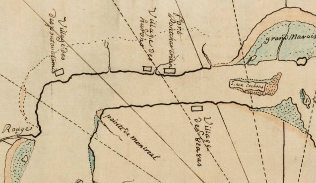
This map was shared by MSU Map Library from the American Indian Historic Collection. It provides a rare glimpse of the “Grand Marais” French for Great Marsh across from Belle Isle. Detroit at this point is simply Fort Pontchartrain next to the soon to be displaced Native American Huron encampment.
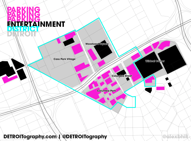
The incremental creep of car culture in Detroit has been welldocumented with the plethora of parking garages and surface lots as opposed to retail and high-rises.
The most egregious visuals of the ills of parking come via the Ilitch property [parking] empire. Not too long ago there were acres of gravel lots where Pizzarena now stands. In the build up to the arena construction in the newly dubbed “Entertainment District” now branded as “The District Detroit” (anyone remember Tigertown?) it seems the biggest boom has been in parking garages with 3 newly constructed even before the arena opened.
Within the Ilitches newly defined “neighborhoods” parking plays a significant role especially when some of those neighborhoods are merely locations for entertainment adjacent to parking options.
| Total Acres | Parking Acres | Percent | |
| Cass Park Village | 72.5 | 8.9 | 12% |
| Wildcat Corner | 63 | 13.13 | 21% |
| Woodward Square | 39.3 | 2.93 | 07% |
| Columbia Street | 10.8 | 1.02 | 09% |
| Columbia Park | 35.1 | 14.51 | 41% |
In many of these areas you will be entertained solely by a walk between stadiums and parking, in Wildcat Corner, the stadiums and parking lots take up 70% of the total acreage. Most notably Columbia Park is nearly half surface parking lots. It’s unclear if those will be new development opportunities or simply parking revenue as the Ilitches have paved and gated these parking lots when before they were simply gravel.
Mappy Hour is back! There is now an official group and this is the official Detroit launch!
We will be learning all about Detroit Greenways Coalition- an organization that provides a collective voice for greenway planning, development and maintenance throughout Detroit.
Graphic design by Hayley Roberts
