Map: Hour Detroit’s Neighborhood Guide

Dennis-Eriksson-Map_layers_HourDetroit

Hamtramck is a neighborhood of Detroit, no question – Hour Detroit has spoken. This funky 50s-ish style artistic map picks and chooses the, perhaps, suburbanite favorite neighborhoods to visit? The map also takes some interesting liberties with denoting place and space. Southwest extends all the way north to Grand River Ave? Midtown Detroit Inc. would definitely contest the zig-zag squiggle shown here as their impact area.

Map: Pedestrian Experience Study in Downtown Detroit

Screen Shot 2018-11-19 at 10.40.11 PM.png

Another revealing map from the I-375 Alternatives Study, the Eastside of Detroit is cut off from Downtown Detroit except for a handful of difficult, narrow, and ill-maintained routes. The planned elevation of I-375 should improve connectivity, which Meijer’s 3rd Detroit location is banking on with its proposed location on E. Jefferson.

Map: Community Gardens and Urban Farms in Detroit 2017

Screen Shot 2018-11-14 at 10.17.47 PM

This is a map of all the past and present community gardens hosted by community groups, churches, and nonprofits as well as large scale urban farming over an acre in size. There is a great amount of opportunity in Detroit for urban growing, but it is not without it’s challenges. More recently, a number of large scale operations have reported multiple break-ins and theft of equipment.

Read more in the full 2017 Detroit Food Metrics Report here.

Map: Detroit Automotive Realm 1972

This map comes from “The Face of Detroit: A Spatial Synthesis” in 1972 by Robert Sinclair at Wayne State University, Department of Geography.

“The Detroit automotive realm is the spatial expression of a vast midwestern manufacturing complex centered upon and organized around metropolitan Detroit. Though most often defined in terms of automobile employment or automobile facilities, this complex comprises an array of associated industries whose separation from the automobile industry is largely a matter of classification convenience. The rubber plants of Akron, Ohio, and Kitchner, Ontario; the metal foundries of Chicago and Cleveland; the machine tool shops of Cincinnati, Ohio, and Windsor, Ontario; the steel industries of Gary, Indiana, and Buffalo, New York; and the electronics and hydraulic research laboratories of Columbus and Dayton, Ohio, are almost as integral a part of the automotive realm as the automobile plants themselves.” (pg. 28)

Map: Shared Streets and Scooter Activity in Downtown Detroit

Screen Shot 2018-10-31 at 10.21.12 AM.png

At last week’s exclusive CityLab Detroit event, Mayor Duggan and Janet Sadik-Khan discussed the collaboration between Shared Streets and the National Association of City Transportation Officials (NACTO). The feature was scooter activity Downtown, which the City has just agreed to expand scooters Downtown and across more neighborhoods.

https://platform.twitter.com/widgets.js

Event: Maptime at Potential in Proximity

PPFINALinsta

Join us at the Detroit Public Library Main Branch where we’ll be joined by other awesome folks presenting on arts and media. We’ll be offering some intro GIS activities and making hand maps!

WHEN: Sunday, November 4th from 1PM to 3PM

WHERE: Detroit Public Library Main Branch, 5201 Woodward Ave. Detroit, MI 48202

Read more about the event HERE

dgei_hand

Map: Freeway Guide for Detroit and Suburbs 1970

This map was intact in the back of an Arrow Street Guide from 1974. Most often the maps have been torn out of the back to be resold or framed by people looking for historic maps. I liked how on ramps and off ramps were specifically color-coded. Today we wouldn’t really think about location of ramps, but this indicates that it was possibly a critical piece of transit planning.

Map: Detroit People’s Atlas of Homes

peoplesatlas-houses.PNG

This submitted map feels very poignant as the Wayne County Tax Auction gears up, city crackdown on landlords has unintended consequences, and legal and illegal evictions continue in a housing market where $2 million can get you a Downtown loft or an entire neighborhood at auction.

Map: Detroit General Population Distribution 1909

Screen Shot 2018-09-11 at 9.29.05 PM.png

This fun colored map was included in the 1913 Detroit Recreation Survey put together on behalf of The Detroit Board of Commerce.

Oddly enough the data generated from this map came from an appraisal survey completed for the Detroit United Railway company. Not surprisingly, the railway would need to know where people were living in order to plan and project their next rail investment. We now have a Census Bureau completing regular surveys, however if we see further cuts to the Census, there very well may be a corporation that starts funding it.

Map: Opportunity Atlas in Detroit

Chetty_opp_index.png

Another “Opportunity Atlas” has been release by Raj Chetty, John Friedman, and Nathaniel Hendren in conjunction with the Census Bureau’s Maggie R. Jones and Sonya R. Porter through Opportunity Insights, a partnership between economists at Harvard University and Brown University. The atlas is already being used by the Kresge Foundation to drive decision-making.

This opportunity atlas/index joins others crafted by the Kirwan Institute and the national Opportunity Index all driven by use of Census data. The difference with the Opportunity Atlas is that it attempts to make future predictions based on the available Census data.

From the CityLab article:

The earlier a child moves to an above-average neighborhood, the greater the gain. On average, a family that moves from a neighborhood that has below-average opportunity to one that’s above-average at the time of a child’s birth can increase that child’s lifetime earnings as an adult by $200,000, and dramatically decreases the likelihood of incarceration, according to the new research. That’s $9,000 more per year than someone who moves in their 20s.

Map: Social Connectedness in Detroit 2016

Screen Shot 2018-09-19 at 4.48.49 PM

Detroit and Wayne County’s “social connectedness” show strong ties within the Mitten as well as some peripheral connections to the south, Mississippi, Alabama, and Georgia. The southern ties are most likely related to the Great Migration of African Americans to northern industrial cities.

More from NYTimes:

This map shows an index of connectedness, created using friendship links between pairs of anonymous Facebook users from a snapshot of the platform in April 2016. The researchers aggregated the links at the county level, so neither the Times nor other academics working with the data can identify individual users within it, or how many Facebook users live in each county. Because counties with more people invariably have links to more places, this map rescales the index to account for differences in population.

Workshop: Data, Mapping, and Research Justice


I’ll be teaching my workshop on data and mapping again this October 2018 with Co.Open/Allied Media Projects.

During the 4-week course we will journey through the entire mapping process; from paper survey to digital database, basic map visualizations, and finally analysis. We will be working with free and open source software (QGIS, LibreOffice, Inkscape, etc.).

Check out some of the past course projects:

Monday nights in October (4 weeks long) 6-9pm

Sign up! HERE


Map: Eat Vegan in Detroit

Screen Shot 2018-09-17 at 8.29.34 AM.png

Esther Loopstra created this beautiful hand drawn illustration map after visiting Detroit for a conference. She excellently highlights: Detroit Vegan Soul, Russel Street Deli, Dilla’s Delights, Mudgie’s Deli, Seva Detroit, Cass Cafe, Ima, Pie Sci, and Trinosophes.


Map: Detroit Strategic Plan for Transportation 2.0

Screen Shot 2018-09-09 at 11.03.57 AM.png

This map comes from the new “Detroit Strategic Plan for Transportation” representing DDOT 2.0, a high-frequency transit system that serves 60% of Detroiters.

Check out the full plan HERE

Possibly the most exciting elements of the plan are for reductions in parking and removal of requirements for parking at new developments when located near transit.

Map: Racial Steering in Detroit Housing 2003-2005

Screen Shot 2018-08-27 at 9.10.48 AM

In 2007, the National Fair Housing Alliance (NFHA) filed a lawsuit against Century 21 Real Estate LLC and it’s franchisee, Centry 21 Town and Country, in federal court. During the 2003-2005 period, NFHA tested 14 real estate agents of which 9 engaged in “racial steering” encouraging whites to seek homes in predominantly white neighborhoods such as the Grosse Pointes and blacks to seek homes in predominantly black neighborhoods such as East English Village.

Detroit Events for City and Map Enthusiasts

pxd_home

Gehl Public x Design

WHEN: September 23 – 25

Together, we’ll dive into issues related to inclusion and equity in public life—the everyday social life of parks, plazas, sidewalks, and other spaces between buildings—and share approaches to planning, designing, and sustaining quality public spaces. Last year we developed an agenda for action. This year, we take it further—but we need your ideas.

ATTENDANCE:

  • Early Bird Student – $195
  • Early Bird Gov/Nonprofit – $295
  • Early Bird Participant – $450
  • Student – $275
  • Gov/Nonprofit – $375
  • Participant – $525

miotke_logo

State of the Map US

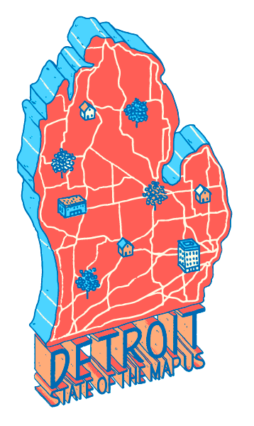
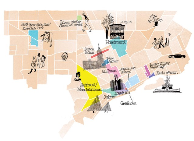
(*Note: Detroit is not the entire Lower Peninsula of the State of Michigan)
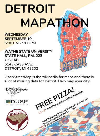
WHEN: October 5 – 7

Join the OpenStreetMap community at State of the Map US in Detroit, Michigan. Connect with other mappers, businesses, government agencies, and non profits, all collaborating around the free and editable map of the world. Share your vision for the project, learn how to work with OpenStreetMap data, and hack on the latest mapping improvements.

ATTENDANCE:

  • Early Bird Student – $25
  • Early Bird Individual – $100
  • Individual – $200

Screen Shot 2018-08-10 at 9.20.24 AM.png

CityLab 2018

WHEN: October 28 – 30

What can city leaders do to fuel innovation that improves quality of life for all? What can rising cities learn from the challenges faced by peers? At CityLab 2018, The Atlantic, The Aspen Institute and Bloomberg Philanthropies will convene the world’s city and community leaders to consider a new narrative worthy of the many global cities whose history may weigh heavy, but whose future holds the promise of a fresh page.

ATTENDANCE: Invitation only

Map: Detroit Streets and Real Estate 1872

silas-farmer-1872

This street map of Detroit was created by city surveyor, Eugene Robinson and published by the Silas Farmer Company (31 Monroe Ave, corner of Farmer St.)

An additional ink stamp on the map reads:

“Waterman’s Real Estate Exchange. First-class Private Residences, Vacant Lots on the Best Streets. Business Property for sale by WM. J. WATERMAN, opposite the Post Office.”

Maps have been such an impactful tool for real estate and land developers for over a century.