WHAT: Mapping Your Local Environment (MYLE) is an introductory workshop that addresses inequitable data representation by training participants in GIS to map local environmental justice concerns. Local journalists, accompanied by environmental justice organizers and other interested community members, will learn to identify and challenge biases by developing critical skills to find, analyze and present relevant local data, combining qualitative and quantitative insights to build powerful narratives.
Join our Data Forum where we will explore tair quality data and community efforts to address the impacts. Join us online for lunch-and-learn filled with insightful discussions, tips, and tricks on all things related to foreclosure data.
We’ll be joined by owner of Darren Riley from JustAir Co, Nina Ignaczak working with Planet Detroit, and Jeff Gearhart from the Ecology Center.
Don’t miss out on this opportunity to connect with fellow data enthusiasts and expand your knowledge in this critical area.
WHEN: Friday, March 14th, 12:30-1:30pm
WHERE: Virtual
WHAT: Join us for our Data Forum where we will dig into air quality data and community efforts to address impacts
Join our Data Forum where we will explore the Wayne County Tax Foreclosure Auction and community efforts to address the impacts. Join us online for lunch-and-learn filled with insightful discussions, tips, and tricks on all things related to foreclosure data.
We’ll be joined by owner of Alex Alsup, who has mapped out the windfall profit potential, Shiva Shahmir working with Outlier Media to spread the word about tax windfalls, and Donovan McCarty from the Detroit Justice Center to share more on policy around tax foreclosure profits.
Don’t miss out on this opportunity to connect with fellow data enthusiasts and expand your knowledge in this critical area.
WHEN: Friday, February 28th, 12:30-1:30pm
WHERE: Virtual
WHAT: Join us for our Data Forum where we will dig into the Wayne County Tax Foreclosure Auction and community efforts to address impacts
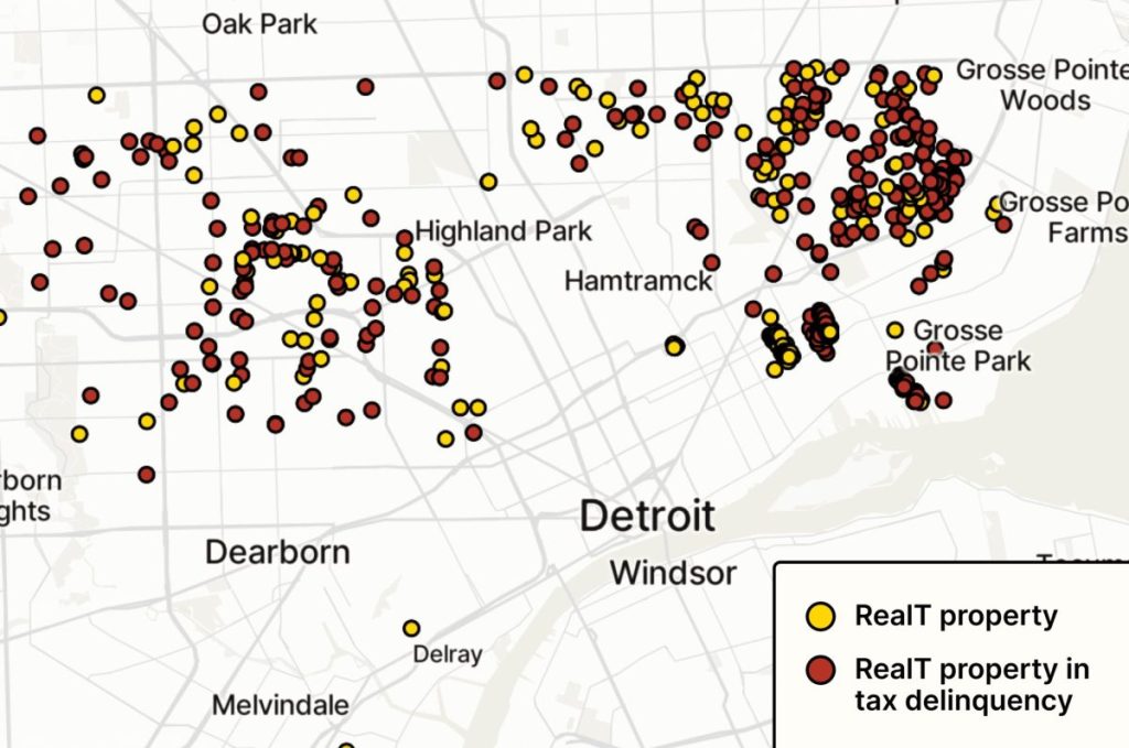
This map by Matt Daniels shows approximately 500 properties that Outlier Media was able to link to RealT. The company says its real estate arm controls about 1,000 Detroit properties.
One of the most concerning discoveries that myself and the team of Property Praxis data volunteers uncovered while coding property speculator entities was that crypto and blockchain had entered the arena. The RealT company owns somewhere between 500 to 1,500 properties in Detroit. They are racking up blight tickets and have unpaid taxes all while the tokenized properties piecemeal change hands daily. Read Aaron Mondry’s full article on Outlier Media.
This is by far the most disturbing trend I have seen in Detroit to date and I expect it will only increase unless something is done about it.
WHAT: The second annual “Demystify Detroit” seminar series begins. This half-day event offers an opportunity to explore the complex overlapping layers of the city’s history, culture, society and economy, guided by local content experts.
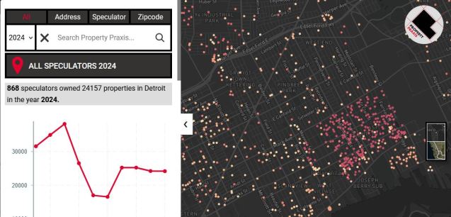
Property Praxis 2.0 launched in November 2024 with 10 years of data on speculative owners of property in Detroit.
Land in Detroit has many different meanings whether you claim to be an “investor” looking to profit, a community leader working to preserve space for people, or local government hoping to generate more tax revenue.
This project is for community members and no one else. The tool allows community groups to dig into who owns bulk property that is contributing to negative impacts on a neighborhood.
At least 20% of land in Detroit is owned by property speculators, defined by the amount of property they own that is not registered to an owner that lives in the same neighborhood. Property speculators benefited from the new inventory of property created by the 2007 subprime mortgage crisis, but in turn fueled the decline of these properties into blight of once intact neighborhoods.
This collaborative mapping project is not the first to examine individuals and corporations that have held large swaths of land in Detroit, but it is the first to examine the true extent of property speculation by digging into the records of shell companies and LLCs that are often used to hide ownership or skirt tax payments. Not all property speculators are bad people, but the process of speculation has far reaching negative impacts on neighborhoods and the people who live in them from loss of homes, exposure to lead poisoning, to a deterioration of overall neighborhood connectivity.
The U.S. Census Bureau publishes updated boundary files every year. The most consequential years are those that fall on the decennial Census: 2000, 2010, 2020. For at least the last 70 years Census Tract boundaries have fallen within the city’s municipal boundary until Census 2020. Census tracts are typically drawn to include between 1,200 to 8,000 people with the optimal goal being around 4,000 people. Census tracts are often used as a default “neighborhood” level of analysis.
The new Census tract boundaries include a handful of oddities that for the most part contribute no change to the Census data reporting. Three boundary changes now extend beyond the city boundary, but add no people to be counted in those extension areas.
It is unclear why the Census decided to expand Census tract boundaries beyond the city boundary when it doesn’t change or improve data collection or reporting and instead opens the opportunity to make data reporting more confusing for Michigan’s largest city.
Rob Linn was a big inspiration for this site to become something real. His mapping topics and data deep dives have given me countless new questions and topics to pursue.
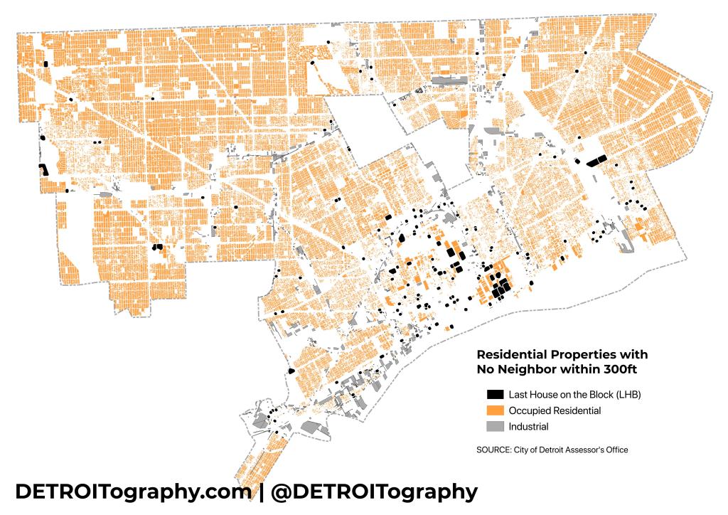
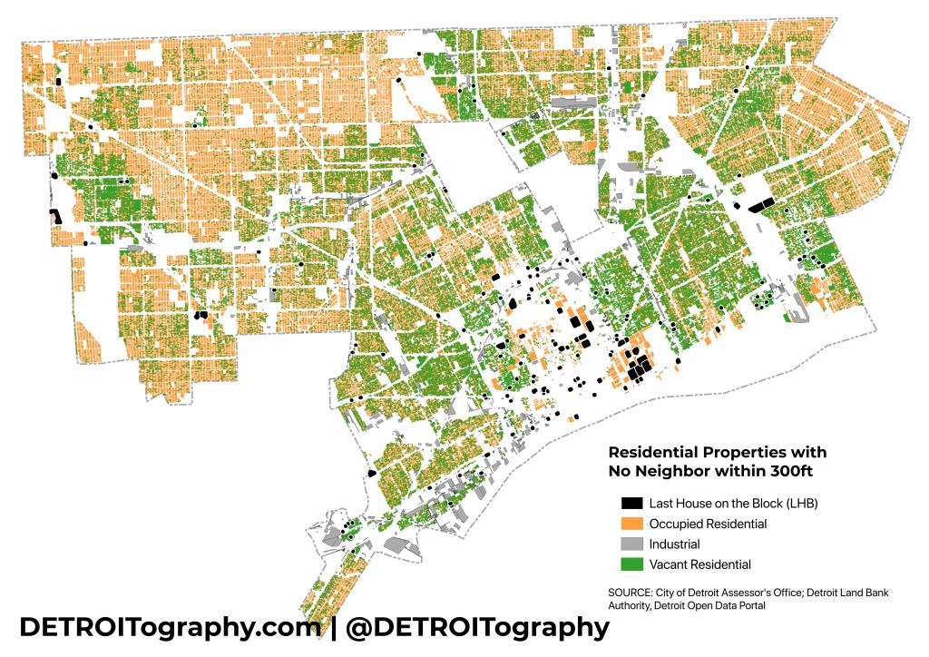
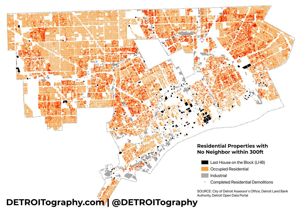
One such topic that Rob mapped in 2010 was the concept of the “last house on the prairie.” In the media hubbub of the late 2000s the concept of Detroit as a urban prairie was commonplace. Rob found the metaphor didn’t hold too well and there were just 134 “last houses on the block” (LHB). One of the LHBs that Rob noted had a recent interview in 2010 has now been demolished. Near St. Aubin and Palmer, there are now no houses on the block (NHB).
I’ve noticed a few LHBs on my drives around the city. The home across from Stanley Hong’s Mannia Cafe on East Baltimore always stood out. The other was a home on French Road just north of I-94. There is another house on Longwood, a dead end street that opens into a forest. Another home sits alone on Beniteau among the Hantz Woodlands. The Eastside has seen many streets clear out and the LHBs happen on multiple blocks of Lakeview and Eastlawn streets.
I decided to test the LHB concept in 2024 after the city has seen mass demolition of over 29,000 homes since January 1, 2014 through the Detroit Land Bank Authority (DLBA) and an influx of targeted investment in the last decade. Utilizing the City of Detroit’s parcel file from the open data portal, I selected all properties coded for residential, single family, apartment, multi-family, and their related codes. I used Rob’s same radius of 300ft and identified 155 LHBs in Detroit. In 13 instances it appears that the demolition program eliminated LHBs that had come up in my previous data analysis.
Rob’s analysis in 2010 found a very dispersed 134 LHBs with some clusters on the Near Eastside and Far Eastside. In 2024, there are more significant clusters in Greater Downtown and the Lower Eastside. It is likely that most LHBs from 2010 were eliminated through demolition and many of these 155 were also created as a result of the demolition program. Hardly an argument for a more rural city, yet vacancy remains high and much of the Eastside has seen a decades-long clearing out.
Join us for our Data Forum where we will dig into coffee shops and places to get coffee from new cafes to panaderias. Join us online for lunch-and-learn filled with insightful discussions, tips, and tricks on all things related to coffee data.
We’ll be joined by owner of Sepia Coffee Project, Martell Mason, coffee-beat reporter extraordinaire Jena Brooker at BridgeDetroit, and me, annual mapper of coffee shop changes!
Don’t miss out on this opportunity to connect with fellow data enthusiasts and expand your knowledge in this exciting field.
WHEN: Friday, January 17th, 12:30-1:30pm
WHERE: Virtual
WHAT: Join us at the Data Forum to dive into coffee shops and tracking places to get your caffeination – all from the comfort of your own home!
Welcome to our Data Forum where we will explore a new category of data each month. This month we will be focused on property data, the relaunch of Property Praxis, and the important details when trying to utilize parcel data.
We’ll be joined by Chase Cantrell of Building Community Value, Joshua Akers, instigator of Property Praxis, and Aaron Mondry from Outlier Media writing on the “speculators of Detroit.”
Don’t miss out on this opportunity to connect with fellow data enthusiasts and expand your knowledge in this exciting field. Register now and secure your spot!
WHEN: Friday, December 13th, 12:30-1:30pm
WHERE: Virtual
WHAT: Join us at the Data Forum to dive into the world of election maps, precincts, and more – all from the comfort of your own home!
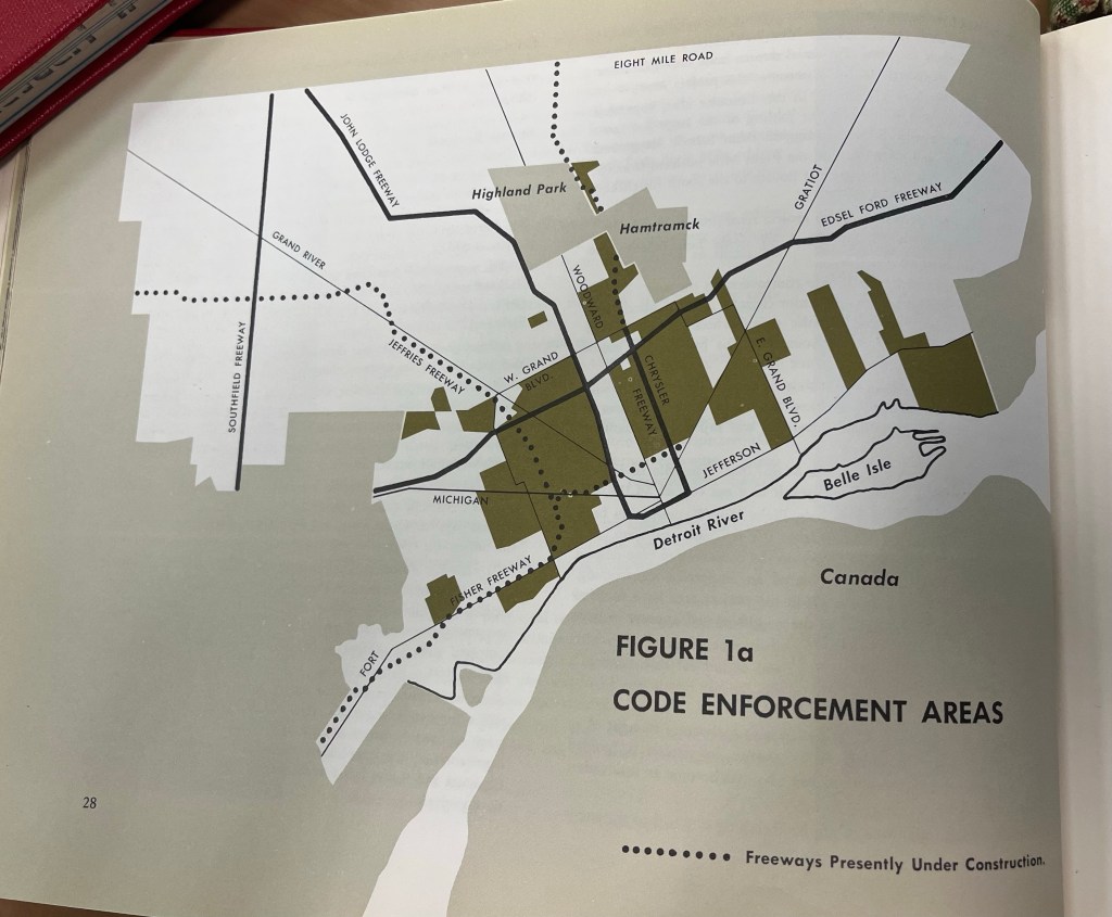
I was pleasantly surprised by the maps in the report: “Detroit: A New City” from the Mayor’s Committee on Community Renewal and prepared by the City of Detroit, Department Report and Information Committee. The city’s Community Renewal Program (CRP) was the vehicle for studying and planning Detroit’s future amidst the federal urban renewal regime. For better or worse the CRP produced numerous reports and maps that chronicle the condition of the city at the time. In particular this map of code enforcement, mostly focused in the “The Middle City” stood out to me as in present day Detroit these areas have seen a fair degree of reinvestment.
The National Community Reinvestment Coalition (NCRC) has put together an incredible interactive map and dataset of all Home Mortgage Disclosure Act (HMDA) data since 1981. HMDA was created as a stop gap to use data to identify if redlining was still occurring. In recent history, HMDA was a data source that demonstrated “reverse redlining.”
“this interactive map shows the geographic spread of originations at the metro-, county-, and Census tract-level throughout the United States in circles of various sizes. High Minority (50-80%) and Very High Minority (> 80%) are shown in light purple and dark purple, respectively.”
Welcome to our Data Forum where we will dive into the world of Election Maps, Precincts, etc. specific to Detroit data. Join us online for lunch-and-learn filled with insightful discussions, tips, and tricks on all things related to election data. Whether you’re a seasoned data analyst or just starting out, this event is perfect for anyone interested in learning more about how data shapes our elections.
We’ll be joined by State Representative Donavan McKinney, reporter Malachi Barrett at BridgeDetroit, and local election data wizard Jackson Franks!
Don’t miss out on this opportunity to connect with fellow data enthusiasts and expand your knowledge in this exciting field.
WHEN: Friday, November 15th, 12:30-1:30pm
WHERE: Virtual
WHAT: Join us at the Data Forum to dive into the world of election maps, precincts, and more – all from the comfort of your own home!
Map puzzle results skewed on purpose, use the link below to try yourself. [Map puzzle] developed by Marie Yu for DETROITography.
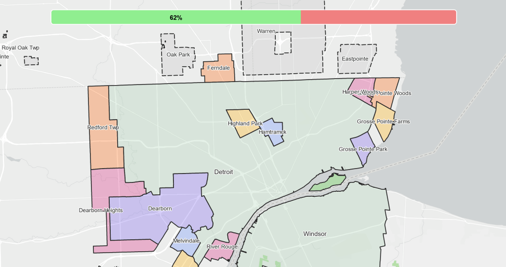
Detroit is bordered by 20 municipalities, can you correctly place all of them? Michigan’s “Home Rule City” Act halted many smaller municipalities from being absorbed by the City of Detroit when it passed in 1909.
Besides being a city, Detroit is also a broad concept in our metropolitan region. Depending on who you talk to Detroit can mean the 9-county economic zone defined by the Detroit Regional Chamber or simply the small expressway bounded area of Downtown if you are a visitor or transplant to the city. Residents of many adjacent cities affiliate with Detroit in order to be recognizable, but don’t always want to be affiliated with the issues associated with the city. Detroit city government leaders live all across the region and overall 70% of workers in Detroit commute in to their jobs.
Today we have a mixed region of large and small municipalities, some successful – some struggling, others very diverse and some not so diverse, but we are all neighbors. How we face the future depends on our collective understandings and shared connections.
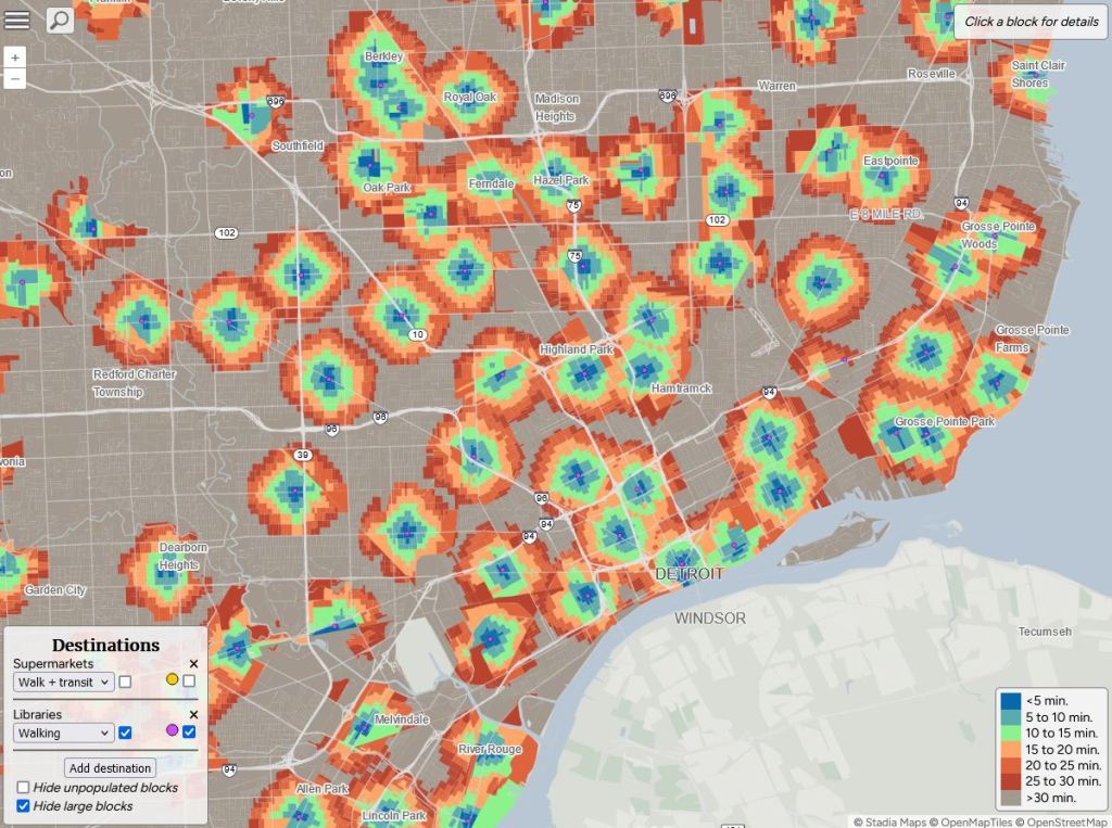
A new tool to measure accessibility and walkability in cities is out called Close from Nat Henry. The tool relies on supermarket and libraries data points in order to assess closeness. Oddly the data sources are not listed, so it is tough to measure supermarkets against our annual updated list of grocery stores and the data clearly doesn’t account for Detroit’s trouble with library funding and branch closures.
These kinds of tools are fun and interesting, but the lack of local nuance makes them tough to get too excited about when these maps might be used to paint a narrative about Detroit that isn’t quite right. The need for improved local data collection is critical.
We are very excited this year to have Jarell Brown, Director of Analytics & Business Intelligence @ The Henry Ford and Principal Innovator of the Innovation Atlas as our keynote speaker this year. We will also be hosted in an incredible space, the Urban Tech Xchange in Downtown Detroit.
Check out the full list of panels, lightning talks, and workshops! Register, submit, or sponsor!
This map in the American Geographical Society Library Digital Map Collection at University of Wisconsin Milwaukee was created by the City of Detroit Department of Report and Information Committee. It’s always interesting to see maps that note the planned expressways. Beyond the city limits the expressways get very curvy and ephemeral.
The route that we would recognize today as the Lodge Freeway is labeled here as I-696 heading from Downtown to Northwest Detroit. Woodward Avenue still had the M-10 designation. The dashed line for the I-94 addition to the West took a bit of a different direction.
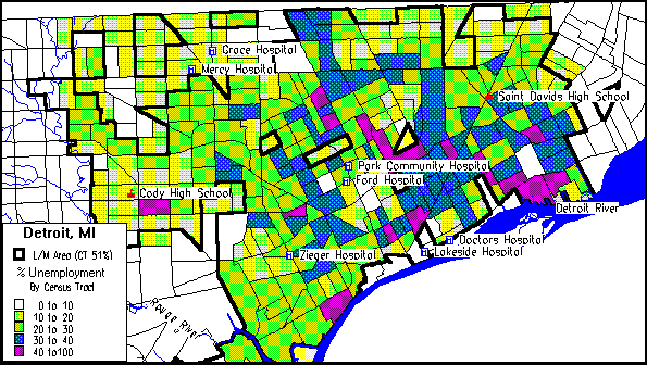
I stumbled across this 1995 HUD plan from when the Planning and Development Department was still on the 23rd floor of Cadillac Tower. I can’t figure out why the Detroit Receiving Hospital is not called out as a point of interest, but enjoy seeing many of the community hospitals marked.
From the report:
The City of Detroit’s Consolidated Plan includes a one-year Action Plan for the expenditure of $56,584,000 in Community Development Block Grant (CDBG) funds, $ 14,105,000 in HOME funds, $2,163,000 in Emergency Shelter Grant funds and $1,207,000 in HOPWA funds.
Anti-Poverty Strategy
Detroit has a poverty rate of over 32 percent. It’s unemployment rate, expected to be 11.6 percent in 1995, is nearly double the state and national rates. As a means of reducing and preventing poverty, the City assigns highest priority to attaining full employment for its residents, with special attention given to those with low skills and other special needs. All major development is assessed for maximum potential for temporary and permanent job retention and creation. The City’s community and economic development activities all have the goal of improving the availability of employment and/or access to employment. The City will continue to follow this policy as the major means of combatting poverty. It is realized that training and re-training in many cases are the primary means for equipping persons out of work with the skills to take jobs which become available in the current and future work place.
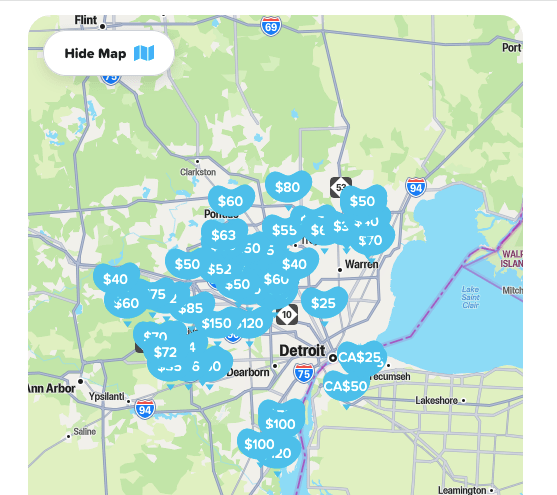
I’ve been asked many times over the years where all the pools are in Detroit. It is a tough question that I’ve tried to crack with aerial imagery, but that was too tedious. Recently, the Swimply site has been popping up in ads this summer and I wondered if this was a useful proxy for pool availability. Swimply let’s you list your pool or other backyard amenities for rent similar to AirBnB except that no one stays the night. Pool rates range from $25/hr to $150/hr including options in Windsor.
The only pool listed in Detroit proper is an above ground pool that can host up to 50 guests although I’m not sure that many people would fit inside the pool listed.
Contact
Submit a map or just get in touch. Thanks for following!