In 2010, Lars Gräbner of Volume One Studio and the University of Michigan Taubman College, began conducting a mapping study of Detroit in order to conceptualize a future for the city.
More from Lars Gräbner:
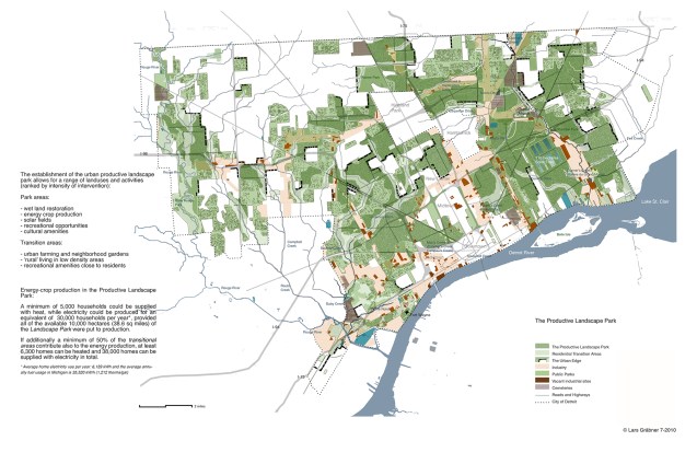
“The establishment of the urban productive landscape park allows for a range of landuses and activities (ranked by intensity of intervention):
- wet land restoration
- energy crop production
- solar fields
- recreational opportunities
- cultural amenities
Transition areas:
- urban farming and neighborhood gardens
- ‘rural’ living in low density areas
- recreational amenities close to residents
A minimum of 5,000 households could be supplied with heat, while electricity could be produced for an equivalent of 30,000 households per year*, provided all of the available 10,000 hectares (38.6 sq miles) of the Landscape Park were put to production.
If additionally a minimum of 50% of the transitional areas contribute also to the energy production, at least 6,300 homes can be heated and 38,000 homes can be supplied with electricity total.
*Average home electricity use per year: 6,139 kWh and the average annual fuel usage in Michigan is 35,520 kWh (1,212 therms/gal)
These maps were featured in Mapping Detroit (Chapter 8: Mapping the Urban Landscape: Revealing the Archipelago) available from the WSU Press.
