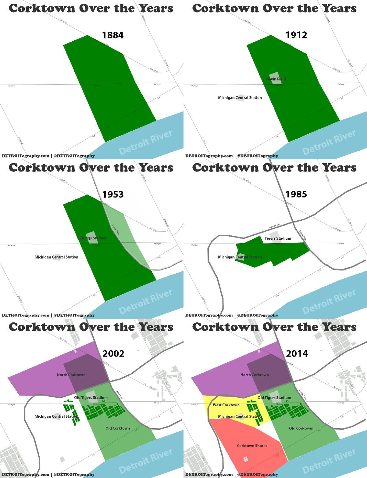
Corktown is many things, but one thing that it definitely is not is definitive. Much like Detroit does not end at the city limits, neighborhoods and communities in Detroit are rarely definitively bounded areas unless there is a strong economic interest involved (i.e. Midtown and Skillman “Good” Neighborhoods). This idea of evolving boundaries and neighborhoods can easily be seen in the birth, decline, and redevelopment of Corktown.
This animation charts the changing area known officially as Corktown as well as the expanding idea of Corktown.
Much of the information in this post is based from Paul’s well researched post on “Corktown’s Blurry Boundaries.”
- 1884 – 1940 – Corktown remains the same main area from it’s epicenter at the Holy Trinity Catholic Parish with a majority Irish residents.
- 1953 – The Lodge Freeway development cuts off a piece of the eastern edge of Corktown
- 1960s – Many areas of the city were in decline and Corktown was no different. The Fisher Freeway construction sliced off the northern piece of Corktown, which became known as the Briggs neighborhood named for the former Briggs Stadium. In the same time period the blight of Corktown was targeted for redevelopment in the West Side Industrial project which significantly reduced the area known as Corktown.
- 1978 – the National Registry of Historic Places (NRHP) designates a small area as historically Corktown.
- 1985 – The Detroit Free Press covers the efforts to expand the historic Corktown area
- 1998 – The historic western portion of Corktown is officially added to the NRHP
- 2002 – The Greater Corktown Development Corporation (now defunct) works to rename Briggs to “North Corktown” in order to benefit from the increasing appeal of the Corktown area.
- 2012 – Green Dot Stables starts referring to their location as “Corktown Shores,” including printed t-shirts, although the area has a strong community identify as Hubbard-Richard.
- 2014 – A couple takes it upon themselves to aid in the redevelopment of the area west of Corktown, referring to it as West Corktown. Many businesses in the area utilize the Corktown moniker to promote their businesses such as Ponyride, Corktown Inn, Hostel Detroit, Le Petit Zinc, and Nancy Whiskey although their respective locations are not historically known as Corktown (i.e. Ponyride occupies the empty triangle in the middle). The West Side Industrial area is still regularly referred to as Corktown.
What is missing?


I am enjoying your DETROITography materials, especially the recent Corktown maps.
Visit MCS one of Corktowns Major items, in virtual reality
http://3dcolab.com/projects/mcs.html
Pingback: Map: Detroit Neighborhoods Game | DETROITography