The short answer is yes, it is time to reassess City Council District boundaries.
The City Charter calls for updated Districts 120 days before the next City primary election. The release of Census 2020 data files gave the City a pass up until now. The 2020 decennial census data was released to State governments for redistricting efforts in August 2021, but the City election in 2021 was already well under way. The next City election for Mayor and City Council seats will be in 2025.
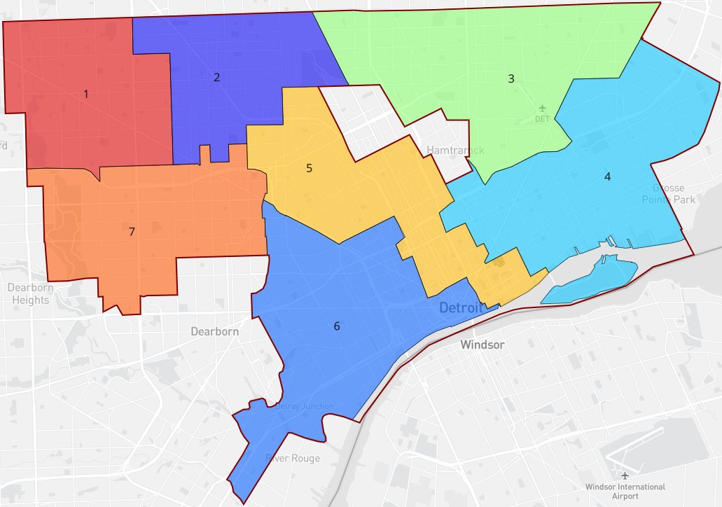
For the 2012 City Charter, the City Planning Commission did the work of creating and proposing Council Districts which would then be approved by the 3-member Detroit Election Commission (City Council President Sheffield, City Clerk Winfrey, Corporation Counsel Mallett). The City has until around February 2025 to finish a Council redistricting process before the April 2025 City primary election (prior to the general election in November 2025).
Sec. 3-108. Geographical Basis for Electing Council Members.
There shall be seven (7) non at-large districts and one (1) at-large district established in the City and one (1) member shall be elected from each non at-large district and two (2) members shall be elected from the at-large district. New district boundaries created within one hundred twenty
(120) days of a City Primary Election shall become effective after the General Election.City Council shall establish district wards that are as nearly of equal population as practicable, contiguous, compact and in accordance with any other criteria permitted by law. District wards shall be apportioned in subsequent years as required by, and in accordance with, the Home Rule City Act, MCL 117.27a, and other applicable law.
COMMENTARY: According to the Home Rule City Act, districts must be drawn based on a specific set of criteria which includes, equal population, compactness and contiguous boundaries. MCL
117.27a(5). Additional language has been inserted to allow for consideration and use of factors not necessarily prohibited by law (e.g. keeping intact precinct boundaries).Lastly, pursuant to the Home Rule City Act, district boundaries are required to be redrawn after every decennial census. MCL 117.27a(4). This section includes this legal requirement.
Precinct Changes
Unfortunately, the City Clerk’s office is not known for keeping great records or administering elections well. There were again surprises with Voting Precinct changes the day of the election – a regular occurrence. Before the 2022 Midterm, a large number of precincts were merged, yet I can find no record or vote by the Detroit Election Commission to approve those changes. It’s not the biggest reason, but concerning to have so many precincts change since 2020 causing 5 precincts to cross Council District boundaries (highlighted in orange).
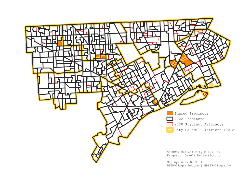
Since 2020, 52 precincts were merged with nearby precincts. Precincts 17, 28, 37, 48, 54, 57, 67, 76, 87, 96, 99, 104, 106, 108, 109, 110, 113, 114, 117, 141, 142, 149, 152, 154, 163, 170, 179, 181, 187, 196, 206, 235, 237, 270, 322, 388, 391, 412, 451, 454, 455, 456, 459, 465, 467, 469, 476, 478, 487, 492, 494, and 499 were all removed in 2022. Big thanks to Will Ferguson for remapping the precinct changes that, as far as I can tell, were only shared out as an unuseable PDF map (04/05/22 2:10PM). Give the people machine-readable, open data!
Map: Who Voted in Detroit? Primary 2022
Population Loss
What may be the most important change is that Detroit has only continued to lose population. When the Council Districts were formed in 2012, they were each roughly 100,000 people. Since then District 6 has gain 5,000 residents (+5%) along with gains in District 1 (+2,618), District 2 (+3,780), and District 7 (+858). District 5 (-4,689), District 4 (-3,024), and District 3 (-4,652) have all seen population losses making for a serious West versus East imbalance in city political representation.

Population is not evenly distributed in Detroit making it difficult to draw lines that balance the more dense pockets of the city.
Population density really shows the disparities in the revitalizing city where there is a Greater Downtown bubble, a ring of low density around Greater Downtown, and most Detroiters living in the Southwest, Northwest and Far East sides.
Detroit Population Density Map 2020

I’ve lamented the data issues with matching ZIP codes to Council Districts as well as using Census Tract level data that have new estimates every year with Council Districts because the reality is that Council Districts were drawn along voting Precinct boundaries not Census geographies. Demographics be damned the Tract don’t vote.
New City Council Districts
Detroit’s current population calls for equally distributed Districts of roughly 90,000 people to meet the criteria of being, “nearly of equal population as practicable, contiguous, compact.” This is my attempt to align with Precinct boundaries as well as the City’s current “neighborhoods” as a means to not split potentially cohesive groups of voters. There are roughly 5 “neighborhoods” that get split in this proposed redistricting, but choices were made based on population numbers. There are plenty of other ways to redraw the lines. I mostly wonder why we haven’t had that conversation yet as a city at large. What would you change?

D1 = 90,177
D2 = 90,856
D3 = 88,300
D4 = 92,779
D5 = 93,839
D6 = 89,670
D7 = 95,224
Other Redistricting Maps

UPDATE: A version of these maps also appeared in the Detroit Free Press online and Sunday print on 12/03/2023

Pingback: Detroit City Council districts are changing: See proposed maps - BridgeDetroit