by Paul Jones III
Detroit has an incredible opportunity to reduce the impact of highways on our urban fabric.
Our highways are some of the worst examples in the nation of racist, mid-century urban planning practices, and removing them has been a topic of interest in transportation, planning, and racial justice circles for decades. As more cities start to make decisions that recognize the relationship between transportation policy, quality of life, and equity, embracing a bold plan to undo the damage of urban highways and restore the city’s walkable grid over time could help Detroit truly take the lead in redefining urban mobility and addressing past harms.
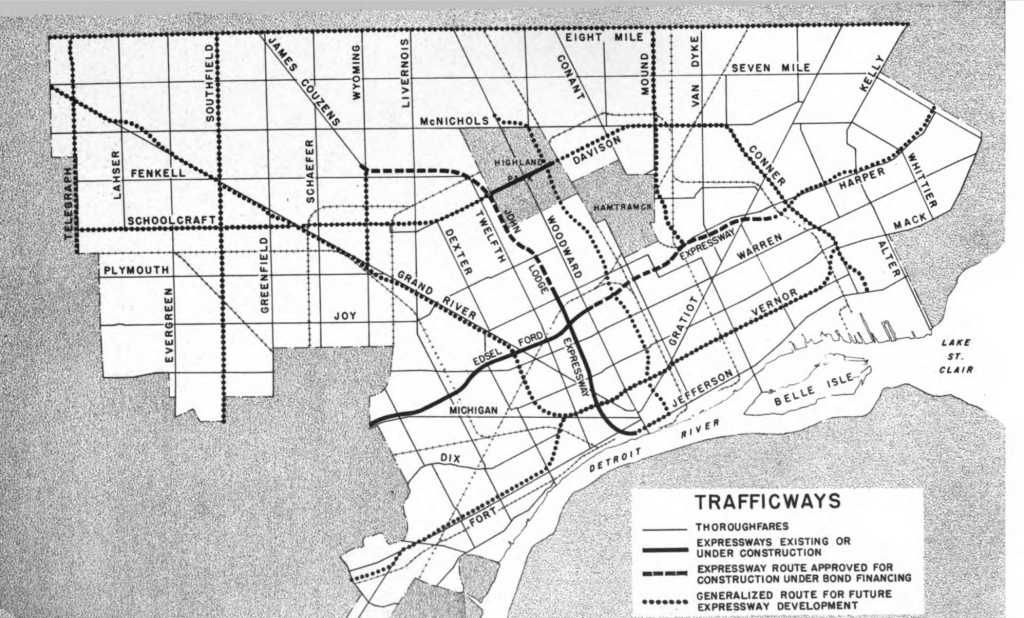
Each highway’s construction undermined density and walkability in the city center and displaced thousands of residents. These displacements targeted Black communities on the east side of downtown and thriving Chinese and Mexican immigrant communities on downtown’s western flank. The pollution, noise, and severed connections from our freeway craze continue to impact quality of life for Detroiters. Freeways have degraded the delicate connections that once held our neighborhoods together. They funnel more cars on our downtown streets than they should handle, and our attempts to design around this have enabled destructive widening projects and minimized the potential for vitality citywide. Our streets are overall wider than our shrinking population justifies and this is especially true downtown. Some of our busiest crossings are dangerous by design for pedestrians. The parking demands associated with freeway access to downtown have cost us countless landmarks and historic structures that have been replaced with surface lots. Our downtown is now tightly surrounded by several lanes of highway and dotted by enormous interchanges, limiting the spread of development. The surface street connections we’ve lost make it difficult to link areas of strength in a way that could really encourage the type of infill development the city needs. Reducing Detroit’s freeway system will address all these concerns and mend the damage highways have done to Black Detroiters and the urban vitality over the last 80 years.
I-375
Most local discussion about freeway removal centers on I-375. The less than 1 mile stretch destroyed the city’s thriving Black Bottom neighborhood and contributed to the displacement of 130,000 mostly Black residents on the east side of Downtown. The stretch has come to the end of its useful life and plans to replace it with a surface-level boulevard by 2027 have been inked by the Michigan Department of Transportation (MDOT). Though the prospect of reversing one of the city’s biggest urban planning mistakes seems promising, the preferred alternative selected by MDOT would be nothing more than a continuation of the harm imposed by car-centric design in Detroit. MDOT’s proposed boulevard looks more like Hall Road than anything that belongs downtown and the design would expose people walking and biking to more danger than the existing freeway configuration. Additionally, without a full acknowledgement of past harms and a reparative plan for restoring ownership and honoring the legacy of Black Bottom, the project will fail to be impactful. Limiting the scope of downtown freeway removal to I-375 misses the much bigger transformation that could take place in Detroit, and MDOT has demonstrated an inability to design appropriately for urban areas. To fully leverage this opportunity, Detroit should reimagine more of its highway system and focus on reestablishing historic street connections.
A bold plan to reduce the city’s freeway system offers a clear opportunity to create a walkable, connected city that could set the stage for the kind of urban vitality city leaders claim to want. In three steps, I’ll explain a proposal for freeway removal in Detroit by removing duplicative sections of the system, replacing them with city-appropriate streets that prioritize people and high quality city blocks over cars and restoring the the city’s urban fabric to promote a balanced transportation system with enough safe space for people walking, biking, and public transit.
Step 1: Removing Duplicative Freeways
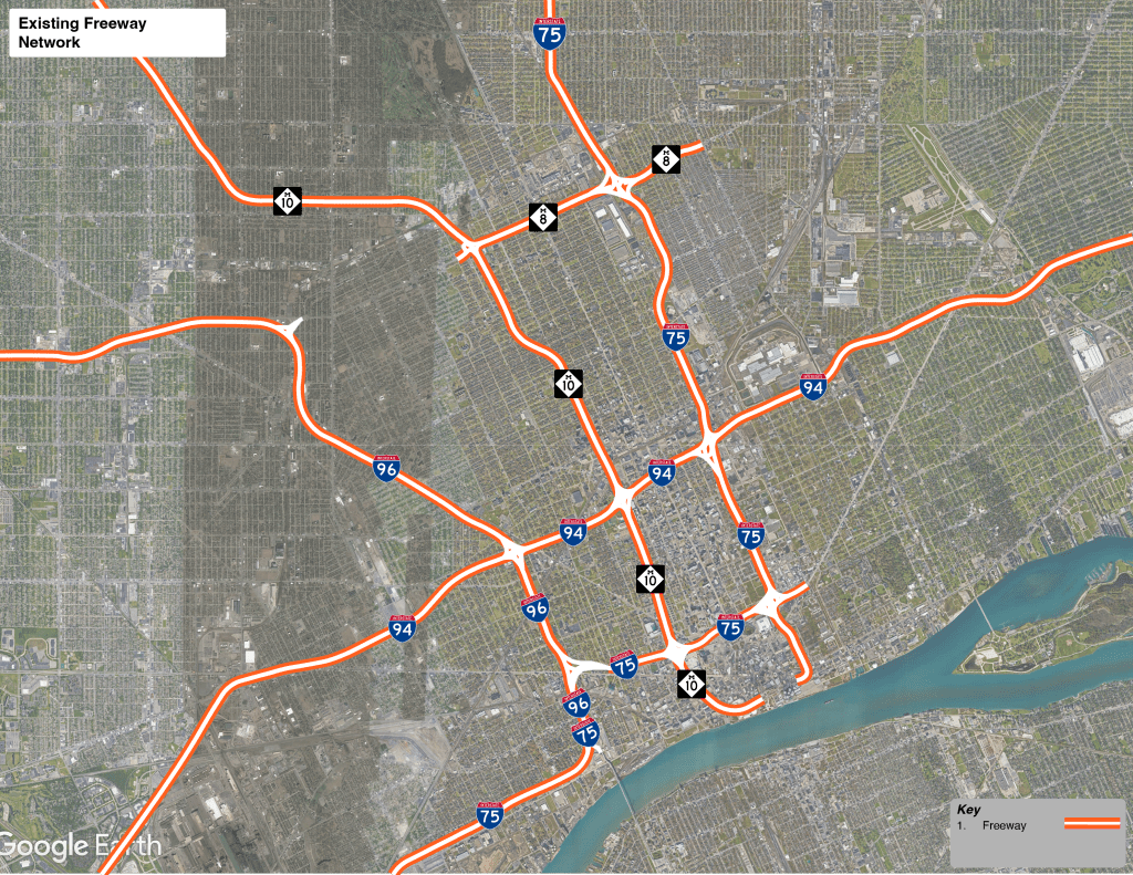
Three of our major freeways, I-96, M-10, and I-75 run parallel to one another as they approach downtown. These stretches are bisected by I-94 and again near downtown by the Fisher Freeway stretch of I-75. From here, I-375 continues to join Jefferson Ave. while M-10, The Lodge, does the same on the west side of Downtown. This redundancy offers the opportunity to consolidate auto access and limit the impact of highways to the periphery of downtown.
Under this proposal:
- I-96 (Jeffries) would remain the same with its I-75 concurrency extended north to I-94
- I-94 (Ford) would remain the same with its I-96 to I-75 stretch becoming a concurrent route for I-75
- M-10 (Lodge) would be reconfigured to turn into the M-8 (Davison) right of way at the current M-10/M-8 interchange and terminate at the present day M-8/I-75 interchange. The existing Lodge freeway south of the Davison would be completely demolished.
- I-75 South at the I-94 interchange would follow the I-94 (Ford Freeway) right of way west and I-96 (Jeffries Freeway) east to rejoin the existing I-75 south designation near the Ambassador Bridge
- I-75 North would follow the I-96 west (Jeffries Freeway) right of way and turn east at the I-94 (Ford Freeway) interchange to rejoin the existing I-75 North Chrysler Freeway stretch
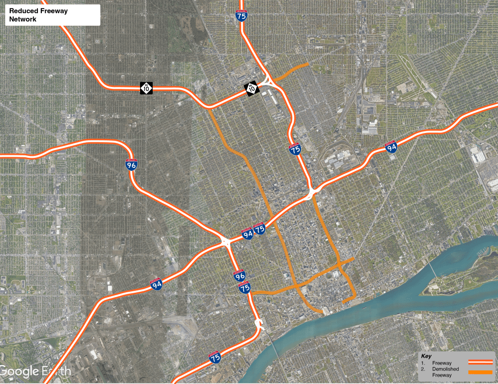
Removing these stretches would free up thousands of acres of developable land adjacent to Greater Downtown, Midtown, and the near west side while lowering the fiscal burden of maintaining overbuilt freeway infrastructure. Extending freeway removal beyond I-375 also offers the City the opportunity to take more reparative action that addresses the damage done by the destruction of Black Bottom, Paradise Valley, Chinatown, and other communities on the near west side. This could take the form of housing built along the reimagined corridors and the development of a Black arts & culture district that celebrates the rich culture and history that urban renewal sought to erase.
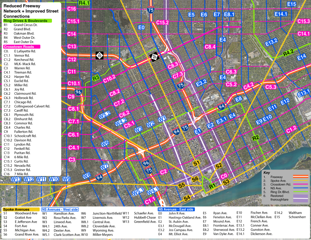
Step 2: Replacing Freeways with City-Appropriate Streets
Hamilton Ave
Currently, Hamilton becomes the Lodge service drive south of Chicago Blvd. With the freeway eliminated south of the Davison Freeway, Hamilton Ave. can be extended as a complete street that follows the historic path of 6th Ave. through New Center, Midtown, and south to Jefferson. This transformation should be complemented with improved public transit along the corridor and a park and ride center at the street’s intersection with the Lodge to help facilitate downtown trips and relieve parking demands.This street would restore connections between Palmer Park, Highland Park, Boston Edison, Virginia Park, New Center, Wayne State, Midtown, Corktown, Huntington Center and the Riverfront.
Hastings Ave
Hastings Avenue would replace I-75 South of the existing interchange with I-94. This complete street would be a nod to the historic, storied Hastings St. that was razed to build the freeway that stands today. Hastings Ave. would connect to Oakland Ave., the 3 block stretch of Hastings St. that still exists between Grand Blvd. and Harper Ave. and extend south, roughly following the now demolished I-75 right of way to Jefferson, and Schweizers Pl to Atwater. This restored street would connect the North End, the Cultural Center, DMC, Brewster-Douglass Site, Eastern Market, Ford Field, Lafayette Park, Greektown, and the Riverwalk along a complete thoroughfare.
Vernor Hwy.
With the Fisher Freeway demolished, Vernor Hwy can be restored as a surface street that traverses downtown. The new Vernor Hwy would connect the existing East and West Vernor Highways while creating a central, signature crosstown corridor for Downtown Detroit that would rival Woodward in destinations and make the journey from Corktown to the Eastern Market an easy walk. Southwest Detroit, Michigan Central Station, new developments around the Tiger Stadium site, new development parcels located in the footprint of the defunct I-75/ M-10 interchange, MGM Grand, Cass Tech, Little Caesars Arena, Foxtown, Comerica Park, Ford Field, Brush Park, The Eastern Market, Lafayette Park, and the Dequindre Cut would all be served by this restored street.
Step 3: Restoring The City’s Urban Fabric to Promote Citywide Mobility
Before freeways, Detroit was a dense, walkable city with a strong grid of connected, tree lined blocks. By prioritizing speeding traffic going directly to the city center, we’ve undermined our ability to build a working transportation network. Although the introduction of freeways tore through and disoriented neighborhoods that were once well-connected to one another and downtown, we have the opportunity to use what’s left to rebuild an even stronger transportation system than the city had at its population and economic peak. Detroiters deserve a safe, thoughtful transportation network that allows residents to travel with dignity even if they don’t own a car. We deserve transportation investments that breathe life into our communities instead of exposing them to more pollution in the name of faster car commutes. A strong vision of freeway removal will be a key element of building that future.
Paul Jones III (@PaulTheUrbanist) is a native Detroiter and recent graduate of the University of Michigan Master in Urban and Regional Planning program. Paul is passionate about the intersection of history, urbanism, and social justice in Detroit and is interested in empowering communities with a working understanding of how the built environment impacts daily life.

Love it. This is the long term goal. Unfortunately unlikely, but we can dream and speak up. The lodge would turn into rail right!?
This is rediculus. We don’t have enough money for schools yet we talk of spending billions on filling in freeways in an already over congested traffic situation. I will stop spending any time or money in Detroit if this is done.
By increasing the amount of public scooter/ cycleways/ tramways it would reduce congestion.
Paul seems to me like you want to make life convenient for all Detroiters, but you really want to remove freeway in areas that have been gentrified. I’m with it, if you are suggesting returning the property to those who were kicked out of Black Bottom due to eminent domain.
This is a unique opportunity to make the city more sustainable for the future. It could pay for itself in renewable energy efficiencies, attracting new business, increased tourism, more effective water management etc. Anyone looked at Curitiba for sustainability as well as Tel Aviv for the introduction of cycleways in a modern city? Neither is perfect but you have to start somewhere…
Maybe Detroit can take care of and develop the already thousands of acres of vacant homes and buildings before needing to remove freeways for the same purpose? Why would anyone take care of Detroit when it can’t even take care of itself? Sure let’s funnel all traffic into one freeway going north and south, for the sake of breaking down the barriers of gentrification.
Love the read. This would be a great improvement to our city that has so much potential.
Under this plan, all the people who work in the service industry would be forced to live downtown. I was a bartender in Detroit for a decade at least. During games (all major professional sports teams are now there) and concerts and 4th of July, I was sometimes forced to pay exorbitant prices to get a hotel room prior to events because it was impossible to get to work on time. I only lived 15 miles, doorstep to doorstep from work, and leaving for work 4 hours early still didn’t get me there on time. I would have gladly moved closer to work, but there was no SAFE AND AFFORDABLE housing available, much less anywhere to park a car. I looked, MULTIPLE times. I’m saying the problem goes far beyond roads. Maybe someone should have thought about that before putting all major sports downtown, on top of 3 casinos, multiple entertainment venues, and one of the largest border crossings in the US.
Pingback: Map: A Radical Vision of Shared Mobility and Transportation Access for Metro Detroit | DETROITography