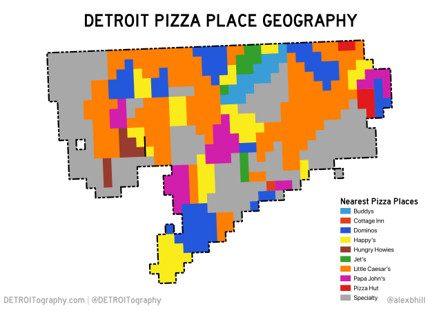
This map idea has been sitting in the back of my head ever since Nathan Yau of FlowingData analyzed the pizza place geography of the United States. The map is based on which pizza place is nearest to particular areas of the city broken down into a grid (microhoods actually – shout out to Motor City Mapping project).
Numerous recent news reports highlight the hoarding of frozen pizza, the rallying of pizza chain stock prices, and the overall growth of pizza chains during the coronavirus pandemic. Pizza Hut, Papa John’s, and Domino’s all reported plans to hire more workers to meet the demand. Where might those people be in Detroit?

Detroit is home to the headquarters or birthplace of multiple pizza chains including: Little Caesar’s (HQ, founded in Garden City), Buddy’s (claim to the “Detroit-style”), Happy’s (founded 1994), and the specialty pizza spots only found in Detroit including Eastern Market staple Supino’s (temporarily closed), Belle Isle Pizza, Amicci’s, Sicily’s, or Pie Sci (my newest favorite). Over half the pizza industry is independent and Detroit has its fair share of unique pizza places including Halal Pizza near the Dearborn border and local chain Pizza Papalis of Greektown.

When it comes to pizza, Detroit has you covered. You might not find your favorite national chain everywhere, but there’s always a unique pizza option close-by.
EDIT: I think my data is actually bad. The two Pizza Hut locations in Detroit have actually been closed for a while.

There is a Hungry Howie’s near me at 1533 E. Lafayette in Lafayette Park not shown. FYI
Sent from my iPhone
>
Correct, however this is not a map of all pizza places, but rather a map that shows closest pizza place per the microhood grid.
Reblogged this on Alex B. Hill.
Pingback: CuriosiD: Who made Detroit-style pizza first? - quarantine fashion