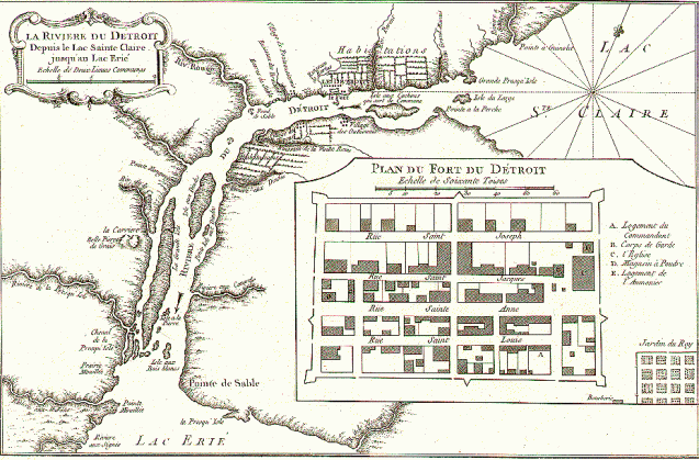
No collection about maps of Detroit would be complete without what might be one of the most reproduced early maps of Detroit. This map is also assumed to be the first printed map of Detroit.
The map is titled, “map of Detroit’s settlement and French fortification” and it is easy to pick out the French ribbon farms along the river. The map was created by Jacques Nicolas Bellin, who was the official French royal hydrographer and ingéniuer géographe de la marine et du Dépot des Cartes et Plans. His responsibilities included the creation of atlases of sailing charts for military, royal, and commercial use. This map in particular was first published in his “Le Petit Atlas Maritime” in Paris (1764), however Detroit had already changed significantly from the time the map was created.
A lesser known fact is that this Bellin’s map was based on the 1749 land survey work of Gaspard-Joseph Chaussegros de Lery who was first commissioned for engineering work to New York in 1742. Later he was transferred from Montreal to Detroit in 1749 where he assisted in the engineering and planning of Fort Detroit.

Pingback: Map: De Lery’s Plan of Detroit 1749 | DETROITography