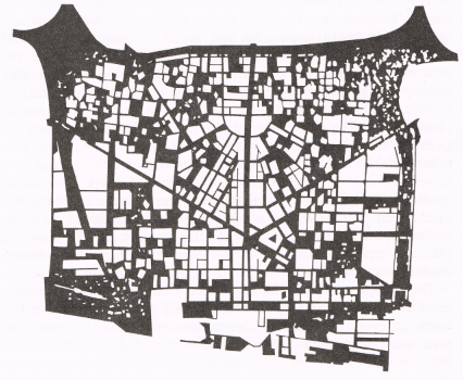
The next “William Bunge Wednesday” is creative mapping idea that show the land area use dedicated to automobiles. The dark areas are roads, parking lots, etc. while the white spaces are buildings and parks. It seems that many of Detroit’s infrastructure woes are built on the back of the shrinking automobile industry. Public transit is next to non-existent due to the automobile industry influence.
EDIT: This is actually a map reprinted by Bunge from Ronald Horvath’s, member of DGEI, ‘Machine Space’ article in 1974

Pingback: Map of Detroit Parking Footprint | DETROITography
Pingback: Map: The Growth of Parking Lots in Downtown Detroit | DETROITography
Pingback: Map: Cyclespace in Detroit | DETROITography
Pingback: Theater of the Every-day (Olivia Howard) – Contested Spaces