by: Laura Bailey “LB” Brandon, map by Joanne Coutts
From my apartment window, I see the Detroit River. On a sunny spring afternoon, small boats float along its edges, carrying silhouettes of fishermen as the current gently pulls them west. The surface is dimpled by ripples, vibrating like static on a blue screen. I imagine standing at the shore where air lifts warmth from water to land, and my body, between the two, acts as a conduit of heat. As I often do, I envision jumping in, riding the river past downtown and south around the bend, drifting downstream away from the city. For this mental journey, I grab hold of Zug Island and climb into the mouth of the Rouge River. I swim upstream, gagging at heavy industry and holding my breath past the sewage treatment plant. After the Dix Ave bridge, I turn right at the fork and paddle past mountains of steel mill slag, until the open river ends. Feeling adventurous, I dive beneath Ford factories to find the path of Campbell Creek, now enclosed by concrete. I track this natural waterway turned underground drainage system north past I-94, below homes and neighborhoods, exploring the streams now tunnels beneath the city. I follow the water to O’Shea Park on the banks of I-96.
My husband, Andy, and I met Jo Coutts at O’Shea Park in early March to lay the groundwork for a mapping project she envisioned. Jo is an activist, writer, and artistic cartographer who spends winters in the Sonoran Desert, supporting humanitarian aid at the US/Mexico border using counter-mapping*. She spends the rest of the year at home in Detroit, lending her time and creativity to advocate for water rights and the rights of water. We initially met Jo at our first Ride With Purpose event in July, 2023. She joined a group of scrappy riders, curious to see how we navigated the city by bike while promoting community efforts of resiliency. Since then, she’s made it to most of our rides and has even led a few, welcoming us and other riders to participate in her Mapping Detroit’s Buried Waterways project. Jo has become a dear friend — someone who challenges my conventional view of land navigation and place, helping me to see that reimagining geography can be an act of both resistance and solidarity.
*Counter-mapping is the practice of creating maps that challenge dominant, colonial, government-sanctioned geographies in an effort to uplift marginalized perspectives such as Indigenous knowledge, community experiences, and social injustices.
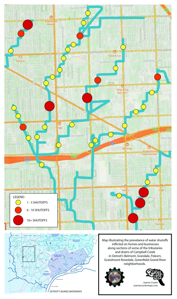
In 2021, Jo began a massive undertaking. She used historical maps of Detroit, layered beneath modern street maps, and a mobile navigation app to reorient herself based on natural waterways and manmade drains that were once exposed to fresh air and accessible to most beings. She mapped buried waterways by riding her bike over 300 miles within the city, following the path of water once seen by the sun. In 2024, she published the What’s Your Water Address Map, a tool for Detroiters to reinterpret their physical address from the perspective of water networks. This year, inspired by the fight for affordable water in Detroit, Jo had the idea to take this concept a step further and use mapping to visually represent a lack of water access in juxtaposition to buried creeks, seeking to reveal the hypocrisy of limiting water to homes built next to and over water sources (which is most of the city). She recognized that blue lines spray-painted in front of homes signified water shutoffs. These blue lines highlight residential water access points and are used to mark places where the Detroit Water & Sewerage Dept (DWSD) planned to terminate service by shutting off the flow of water to a home. Typically these shutoffs were carried out when someone couldn’t afford to pay their water bill, like in 2014 when DWSD initiated the largest residential water shutoff in US history, ending water service for over 30,000 households, an unjust act that was challenged by residents and local activists, brought to court by both the ACLU and NAACP, and condemned by the United Nations as a human rights violation.
From O’Shea Park in early March, Andy, Jo, and I followed a route we made using Jo’s buried creeks map as a reference — a bikeable loop which connected about 4 buried waterways. We rode slowly through neighborhoods in this northwest section of the city (Plymouth-I96, Schoolcraft-Southfield, Greenfield-Grand River, Hubbell-Puritan, Harmony Village, Bethune, Happy Homes, Grand River-I96, and Plymouth-Hubbell), mentally noting the number of blue lines on each block. During this practice ride we learned to keep on sidewalks to spot blue lines, avoid commercial areas (where homes were scarce) and dangerous intersections (where biking was hazardous). A week later, Andy and I returned to ride 3 more waterways through adjacent neighborhoods (Barton-McFarland, Littlefield, Northwest, and Grand-River-I96, plus Grandmont and Crary/St Marys). We recorded data by tallying blue lines on each block and noting the number on maps we kept in our pockets. All this was in preparation to lead a group of riders on a map-building quest for our 21st Ride With Purpose event.
On Saturday March 21st, the day before World Water Day, Andy, Jo, and I returned to O’Shea Park with maps, pens, and words to share with whoever decided to join our first ride of the year. Soon cars started pulling up with bike racks packed — a few friends, though mostly new acquaintances. Fourteen people came to ride that day, eager to enjoy an afternoon in the sun and intrigued about our counter-mapping project. From those who lived in the city to folks who drove from the burbs, some who hadn’t ridden in years to others who cycled year-round — all with a common goal to experience both outdoor recreation and community activism. Once the group had gathered, Jo spoke about her work mapping waterways, Andy talked about biking etiquette, and I explained the task at hand, how we’d carefully collect data and use it to build our map. We asked for a few volunteers to be data-collectors and note-takers, then we mounted our bikes and hit the trail. The beginning of our ride followed a grassy path to a highway overpass. We pedalled hard up and over I-96, then stopped on the other side to see an example of a blue line. From there, we rode steadily north along neighborhood streets, occasionally crossing commercial corridors. Everyone seemed relieved to feel the heat of the sun on their faces, their skin chilled by the cool air and eased by the light breeze. We stopped every few blocks for our note-takers to record the number that data-collectors discreetly shared with them. It was important that we didn’t single out residences, record personal information, or make assumptions.
Our route took us north, then east, then north, then east — a staircase pattern tracing the flow that water once took. When pursuing buried creeks, you can’t follow every turn and curve of a natural waterway with the squareness of the built environment standing in your way. We did our best using the grid of neighborhood streets. When we reached the end of one waterway along Puritan St (south of W McNichols) we turned back and used Schaefer to cut south towards another. Again we followed a staircase pattern, following the water we couldn’t see. We stopped for a break on a grassy corner and tended to a data-collector’s flat. One of the riders and his kiddo (who rode in a child’s seat on the back of his bike) had to pedal ahead for dinnertime. We shared hearty goodbyes. After changing the flat we realized that all 3 patch kits we brought were expired, and the best patch didn’t hold. (In hindsight, we should have used a tube!) Luckily a plan was devised to safely return the inoperative bike to O’Shea, leaving us down another 3 riders. Those that remained continued on the mapping journey. We rode the invisible water back to our starting point, glad to be together and reunite with our break-away riders. After some reflection and more connections, we gathered for a group shot and thanked each other for the time we shared together. It was inspiring to see so many like-minded individuals willing to explore less-frequented biking routes in pursuit of community well-being.
Before Jo pointed out the blue lines, I had never even noticed them. Now I see them everywhere. They remind me that the city controls our water and we are never guaranteed what should be a basic human right. When I spot a blue line, I hear the voices of comrades in the struggle for water rights, like my friend Val of the People’s Water Board Coalition who’s been directly impacted by the shutoffs and has been fighting for statewide water affordability for over a decade. To her, these markers were known as “blue lines of shame” — identifiers that stigmatized residents who struggled to afford high water bills. Our goal with this project was to reverse this narrative, showing, from a street-level view, that water access affects entire communities, not just individuals and families. We want people to see the absurdity of limiting water access in a city built on water. Having your water shut off is no moral failing, it is a consequence of a system that values money over people. The data we collected in northwest Detroit was used to create a map of water shutoffs over buried waterways. While the data isn’t 100% accurate, we feel that the map is a fair representation of this concept. Whether it’s your water, your neighbor’s water, or someone down the block, we all need water just as much. Water should be affordable, accessible, and sustainable regardless of where you live or how much you can afford. Maybe one day we can bring the light of day to some of our city’s waterways…
Save the date for our next Ride With Purpose event!
Follow @ridewithpurposedetroit to stay in the loop.
Date: Sunday, June 28th
Time: 2pm to 5pm
Address: 1812 Field St, Detroit, MI 48214
Partner: Detroit Community Fridge
Route: ~14 miles, round-trip
Activity: Cleaning & stocking community fridges on the eastside
