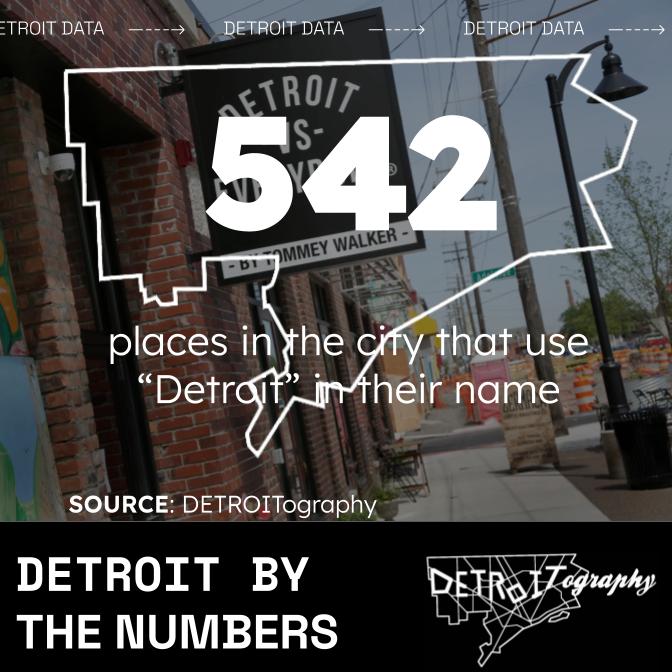
DETROITography

Menu

Skip to content
  • About
  • Our Maps
  • Events
  • Neighborhoods
  • Resources
  • Find Data
  • Learn
  • Participate

Detroit By The Numbers: January 2024 Data Roundup

February 7, 2024 By Alex B. Hill

542

“Detroit” places in Detroit, next most is 23 in Southfield (Model D Media)

39%

Homeless families report domestic violence (City of Detroit)

$16.5 million

Awarded to the City government for service line replacement in two areas: Midtown (Cultural Center, Medical Center, Midtown) and Barton-McFarland [McFarlane?] (EGLE)

1 million

Qline riders in 2023, a 50% increase from 2022 (QLINE)

Share this:

  • Click to share on Bluesky (Opens in new window) Bluesky
  • Click to share on LinkedIn (Opens in new window) LinkedIn
  • Click to share on Nextdoor (Opens in new window) Nextdoor
  • Click to email a link to a friend (Opens in new window) Email
  • Click to share on Facebook (Opens in new window) Facebook
  • Click to share on X (Opens in new window) X
  • More
  • Click to print (Opens in new window) Print
  • Click to share on Reddit (Opens in new window) Reddit
  • Click to share on Pinterest (Opens in new window) Pinterest
Like Loading...

Related

Posted in Data | Tagged Barton-McFarland, data, Detroit, Detroit By The Numbers, DetroitData, DETROITography, domestic violence, EGLE, homeless, lead service lines, Midtown, million, places, points of interest, Qline, transit | Leave a comment |

Post navigation

← Hispanic Population Map of Detroit
Map: New Detroit City Council Districts for 2025 →

Leave a comment Cancel reply

Around Art Buildings Crime Data Demographic Economic Education Employment Environment Events Food Health History Income Land Parking Podcast Politics Population Property Race Transit

Popular

  • Map: Detroit Food Pantry Finder 2025
    Map: Detroit Food Pantry Finder 2025
  • Detroit Redlining Map 1939
    Detroit Redlining Map 1939
  • Detroit Racial Dot Map 2020
    Detroit Racial Dot Map 2020
  • Where Commuters Run Over Black Children, Detroit 1968
    Where Commuters Run Over Black Children, Detroit 1968
  • Map: Healthcare Access in Detroit: a geospatial analysis
    Map: Healthcare Access in Detroit: a geospatial analysis

Enter your email address to follow this blog and receive notifications of new posts by email.

Join 6,806 other subscribers

Books!

Follow

Tweets by detroitography

Like

Like
Subscribe
Create a website or blog at WordPress.com

Contact

Submit a map or just get in touch. Thanks for following!
hello@detroitography.com
×
  • Comment
  • Reblog
  • Subscribe Subscribed
    • DETROITography
    • Join 630 other subscribers
    • Already have a WordPress.com account? Log in now.
    • DETROITography
    • Subscribe Subscribed
    • Sign up
    • Log in
    • Copy shortlink
    • Report this content
    • View post in Reader
    • Manage subscriptions
    • Collapse this bar
 

Loading Comments...
 

    %d