
by: Dan Seiderman
One of my biggest complaints about navigating Detroit is how disconnected the streets are. On foot, by bike, or in a car, getting around the city can be unnecessarily confusing because of the division caused by the freeways, the mash-up of different grid systems, and the inconsistent development patterns.
In addition to my personal experience, a lot of the inspiration for this project comes from Paul Sewick’s “Detroit Urbanism” blog and his series on the Woodward Plan, in particular. It was this blog that made me realize how incomplete the Woodward Plan really is. Much of the confusion of downtown is due to the inelegant way that the Woodward Plan is cut off and forced into a rectilinear plan west of Cass, east of Brush, and below Michigan and Monroe.
To visualize a more connected Detroit, I created two sets of maps that include road networks, transit networks, and zoning. There is one set of maps for downtown and one set of maps for a generic square mile of greater Detroit. I like to imagine that these two sets of maps could be used as templates to create a master plan of the city to redevelop its transportation system. In this fantasy master plan, downtown anchors the city while the square mile grid is repeated to the city limits, making occasional adjustments for spoke roads, freeways, railways, parks, and changing grid orientation. The goal is to have an easily navigable city with plenty of greenery, good public transit, and regularly spaced thoroughfares that don’t end abruptly.
Road Network
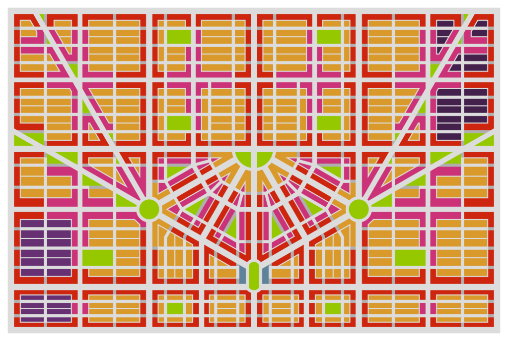
Downtown
To create my idealized map of downtown, I started by laying out the centerlines of the Woodward Plan in Fusion 360. I adjusted the plan so that the upper section is complete but the section below Michigan and Monroe is largely the same as it is currently. I also added a half mile to the West, North, and East to provide context of how downtown would fit into the larger city grid. I then used Inkscape to widen these centerlines to specific widths and color coded them by street type.
There are several major changes between this idealized map and what exists currently. One major change is that I have re-aligned a few of the spoke roads (and added a new one) to connect more directly with Campus Martius. Bagley and Grand River have been shifted to meet Michigan and 2nd Ave at a large roundabout. Similarly, Gratiot and Madison have been shifted and Mound Rd has been extended to meet Monroe and St Antoine at a large roundabout. These roundabouts are intended to provide park space as well as a safe intersection for the 7-way crossing. They are similar in size to Dupont and Logan circles in Washington, D.C. I also re-oriented Campus Martius to be more intuitive to navigate in the surrounding grid.
I applied road hierarchy concepts to further develop the grid. The 120ft avenues function as arterials, the collectors connect local streets to the avenues, and alleys provide service access to lots without clogging up traffic. To simplify intersections, local streets are converted to pedestrian streets where they meet 120ft avenues and at intersections with more than four legs. The 100ft avenues function somewhere between an arterial and a collector. Except for Woodward, tram lines are spaced roughly every mile.
 |
| Map by Dan Seiderman |
Greater Detroit
The logic behind the rectilinear sections of the downtown network can be seen more easily in the square mile grid:
- 120ft Avenues are spaced every ½ mile.
- Tram lines are spaced every mile.
- Stops are spaced every ¼ mile.
- 90ft Collectors are spaced every ¼ mile.
- 60ft Local Streets are spaced every:
- ⅛ mile from west to east.
- ⅟16 mile from north to south.
- 60ft Pedestrian Streets are implemented where local streets meet avenues.
- 20ft Alleys only connect to local streets.
This setup ensures that a thoroughfare exists every ¼ mile. Additionally, these thoroughfares (90ft and wider) should all include dedicated bike lanes to provide a robust cycling network. Regarding the pedestrian streets, they allow permeability for pedestrians and cyclists while encouraging motor traffic to move through the city via the collectors and avenues. This incentivizes drivers to use local streets only for local traffic. It also provides pedestrians with an unbroken path along avenues for multiple blocks and gives corner businesses space for outdoor dining.
 |
| Map by Dan Seiderman |
Subway Network
Downtown
Though Detroit’s population continues to decline, a future, thriving version of the city would need a robust public transit system. In addition to tram lines, my idealized plan calls for a subway system to fill this need. The spoke roads make an obvious starting point for a subway network since they radiate out from downtown and reach far into the suburbs. By adding a secondary grid network on top of this, an interwoven and well-connected system forms. Stops are spaced approximately every ½ mile for local service and every mile for express service.
With so many transit lines leading to Campus Martius, it would naturally make a great transit hub. In this plan, there are: five subway lines (Michigan, Grand River, Woodward, Mound, and Monroe) and 2 tram lines (Fort and Woodward) that all converge on the park. All this connectivity would make it a great location to add commuter and intercity rail. By branching off from existing rail lines around Fort St and Rosa Parks Blvd, a new line could be buried along Fort to bring these services to Campus Martius. Another line could branch off on the east side and connect to Campus Martius to form a passenger rail loop around downtown. The plots on both sides of the park could be used as stations, with the west station serving as a terminus for trips to the south and west and the east station serving as a terminus for trips to the north and east. Platforms for through-running tracks could be placed on a level below the terminus tracks to make this rail hub a real powerhouse.
In addition to many other intercity and regional rail connections, a link could be made between DTW Airport and Campus Martius that would take only 15-20 minutes. From Campus Martius, commuters and tourists could reach destinations such as:
- The Fisher Building
- Time: 10 minutes
- Route: Woodward Express up to Grand Blvd then a 5-minute walk
- The DIA
- Time: 5 minutes
- Route: Woodward Express to Warren then a short walk
- Eastern Market
- Time: 10 minutes
- Route: Mound Local to Temple
- The Renaissance Center
- Time: 10-15 minutes
- Route: Walk
- Jefferson North Assembly Plant
- Time: 15 minutes
- Route: 5-minute walk to Hart Plaza then 10 minutes on Jefferson Express
 |
| Map by Dan Seiderman |
Greater Detroit
Outside of downtown, subway lines are spaced every mile, alternating with tram lines so that there is rail transit every ½ mile. Local stops are spaced every ½ mile; express stops are spaced every mile.
 |
| Map by Dan Seiderman |
Zoning
Downtown
With these idealized road and transit networks, a zoning pattern is needed to bring the streets to life so that people have destinations in this more connected city. To encourage a lively city with an easily repeatable development pattern, I created the following scheme:
- Avenues are zoned for commercial.
- Collectors are zoned for mixed use.
- Local Streets are zoned for residential.
- Small and oddly shaped blocks are zoned as parks.
- Additional parks are spaced so that the closest one is no more than a five-minute walk away.
Local streets can also be zoned for industrial such as in Eastern Market and Corktown. This would create a similar environment to the business parks in the suburbs in the sense that industrial centers would be isolated from residential areas and through traffic would be restricted. Since they are surrounded by commercial along their thoroughfares, it would help to maintain a safe and friendly environment for pedestrians and cyclists even in an otherwise industrial area.
 |
| Map by Dan Seiderman |
Greater Detroit
The zoning scheme can be more easily observed in the generic one-mile square grid outside of downtown. Pockets of housing are surrounded by commercial corridors and occasionally broken up by large parks.
 |
| Map by Dan Seiderman |
Conclusion
To attract people to the city, redevelop empty blocks, and remove excessive surface parking from downtown, Detroit needs a solid transportation network that gives people options to easily navigate the many opportunities that the city provides. While rebuilding the city exactly according to these maps may be impossible, many of the concepts are relatively easy to apply. Concepts like multi-modal streets, mixed-use zoning, plenty of park space, and regularly spaced thoroughfares all lead to a more connected city.
A more connected city is one full of opportunities. A city with a coherent network of roads is one that makes it easy to develop public transit routes. A city with good public transit is one where people of all means can easily get around without sitting in traffic. A city where people spend less time sitting in traffic is one where people are happier and more productive. A more connected Detroit is a thriving Detroit.

Thank you for the interesting information about Envisioning a more connected Detroit. I hope that some of these ideas are implemented.