Planning a city is a big job, but is it too much to ask for a coordinated effort?
The number of disparate boundaries in Detroit is both fascinating and befuddling: police scout car areas, curbside trash pickup zones, fire hydrant company areas, and on and on.
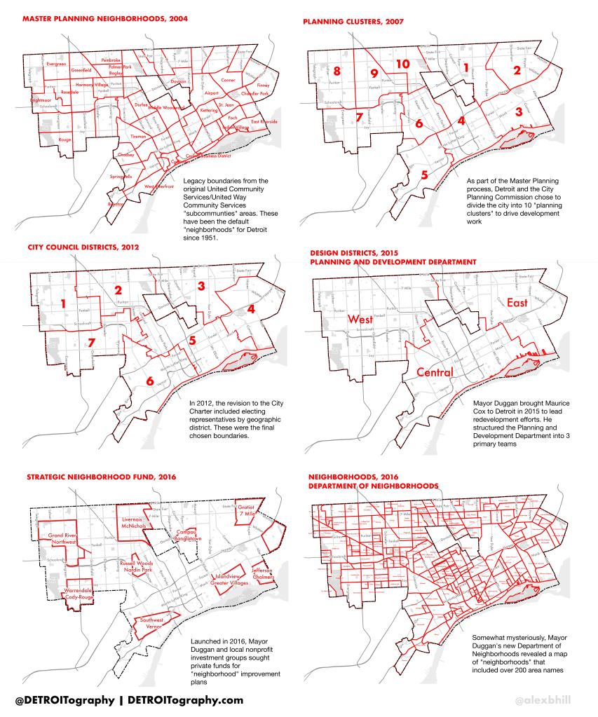
This post will focus on the various planning boundaries and what they mean for you. The boundaries will be discussed in chronological order, but all of these boundaries are actively used to plan the city’s future.
Master Plan Neighborhoods, 2004: These boundaries are the legacy of the United Community Services/United Way Community Services “subcommunities” first developed in 1951 and drawn along Census Tract boundaries so that Census data could be used to compare areas. These 54 areas have been the official “neighborhoods” since that time and remain so since the City’s Master Plan has not been updated since 2004.
Planning Clusters, 2007: The City Planning Commission decided to break the city up into 10 clusters based on the Master Plan Neighborhoods in order to focus development work. These clusters are still written into the official work of the Planning and Development Department.
City Council Districts, 2012: The City voted to elect representatives by geographic district as part of the City Charter revision. The final boundaries only align with Census Block boundaries making it difficult to match any demographic data to districts.
Design Districts, 2016: Mayor Duggan brought Maurice Cox (now planning director for Chicago) to the city to move his neighborhood work forward. As part of that effort Mr. Cox restructured the Planning and Development Department into 3 large “design districts” based on combining different City Council Districts.
Strategic Neighborhood Fund, 2016: Mayor Duggan creates a public-private fund to initiative “neighborhood” planning work in a few hand-picked areas. The Strategic Neighborhood Fund areas do not align with any other “neighborhood” boundaries. Hundreds of millions have been raised to support development work in this areas.
Neighborhoods, 2016: Mayor Duggan’s new Department of Neighborhoods (DON) adopts an interesting and controversial set of some 200+”neighborhood” boundaries largely based on the work of a local tech company and not based on community feedback.

Reblogged this on Alex B. Hill.
Pingback: Map: Neighborhood Cluster Boundaries 2005 | DETROITography