DETROITography

Menu

Skip to content
  • About
  • Our Maps
  • Events
  • Neighborhoods
  • Resources
  • Find Data
  • Learn
  • Participate

Map: Detroit Strategic Plan for Transportation 2.0

September 10, 2018 By Alex B. Hill

Screen Shot 2018-09-09 at 11.03.57 AM.png

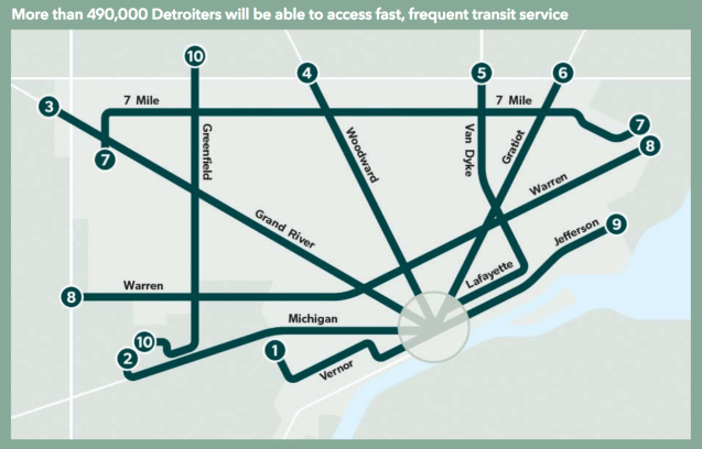
This map comes from the new “Detroit Strategic Plan for Transportation” representing DDOT 2.0, a high-frequency transit system that serves 60% of Detroiters.

Check out the full plan HERE

Possibly the most exciting elements of the plan are for reductions in parking and removal of requirements for parking at new developments when located near transit.

Share this:

  • Click to share on Bluesky (Opens in new window) Bluesky
  • Click to share on LinkedIn (Opens in new window) LinkedIn
  • Click to share on Nextdoor (Opens in new window) Nextdoor
  • Click to email a link to a friend (Opens in new window) Email
  • Click to share on Facebook (Opens in new window) Facebook
  • Click to share on X (Opens in new window) X
  • More
  • Click to print (Opens in new window) Print
  • Click to share on Reddit (Opens in new window) Reddit
  • Click to share on Pinterest (Opens in new window) Pinterest
Like Loading...

Related

Posted in Parking, Politics, Transit | Tagged biking, DDOT, Detroit, Detroit Department of Transportation, Detroit Strategic Plan for Transportation, FCA, Ford, GM, map, parking, plan, technology, walking | Leave a comment |

Post navigation

← Map: Editing the Detroit City Map
Map: Detroit Youthful Population from School Census 1912 →

Leave a comment Cancel reply

Around Art Buildings Crime Data Demographic Economic Education Employment Environment Events Food Health History Income Land Parking Podcast Politics Population Property Race Transit

Popular

  • Map: Detroit Food Pantry Finder 2025
    Map: Detroit Food Pantry Finder 2025
  • Map: The Original Midtown Community 1953
    Map: The Original Midtown Community 1953
  • Detroit Redlining Map 1939
    Detroit Redlining Map 1939
  • Where Commuters Run Over Black Children, Detroit 1968
    Where Commuters Run Over Black Children, Detroit 1968
  • Detroit Racial Dot Map 2020
    Detroit Racial Dot Map 2020

Enter your email address to follow this blog and receive notifications of new posts by email.

Join 6,806 other subscribers

Books!

Follow

Tweets by detroitography

Like

Like
Subscribe
Create a website or blog at WordPress.com

Contact

Submit a map or just get in touch. Thanks for following!
hello@detroitography.com
×
  • Comment
  • Reblog
  • Subscribe Subscribed
    • DETROITography
    • Join 630 other subscribers
    • Already have a WordPress.com account? Log in now.
    • DETROITography
    • Subscribe Subscribed
    • Sign up
    • Log in
    • Copy shortlink
    • Report this content
    • View post in Reader
    • Manage subscriptions
    • Collapse this bar
 

Loading Comments...
 

    %d