Map: Predicting Gentrification in Detroit with Longitudinal Census Data

screen-shot-2017-02-19-at-5-54-48-pm

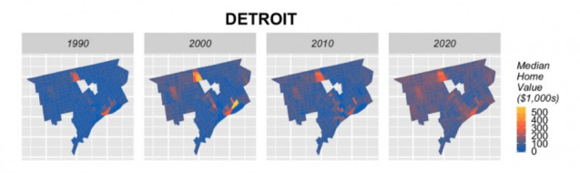
Ken Steif and his team at Urban Spatial note the Urban Institute’s call for an early warning system for gentrification in US cities. In response, they decided to start analyzing data and building models to help predict gentrification potential. The above map is based on models run with 2000 and 2010 data to forecast at the census tract level for the year 2020.

One thought on “Map: Predicting Gentrification in Detroit with Longitudinal Census Data

  1. Pingback: DETROIT | Site Title

Leave a Reply

Fill in your details below or click an icon to log in:

WordPress.com Logo

You are commenting using your WordPress.com account. Log Out /  Change )

Facebook photo

You are commenting using your Facebook account. Log Out /  Change )

Connecting to %s