 In 2010, Lars Gräbner of Volume One Studio and the University of Michigan Taubman College, began conducting a mapping study of Detroit in order to conceptualize a future for the city. This was well before the Detroit Works Project (DWP) and Detroit Future City (DFC) even entered the “future planning” arena. You can see many of his ideas reflected in those plans, but with an absence of his goal to consider the indeterminate and highlight the potentially liberating practice of mapping for the future.
We’ll be sharing a map each week (12 total) from his Detroit mapping project, which was featured in Mapping Detroit (Chapter 8: Mapping the Urban Landscape: Revealing the Archipelago) available from the WSU Press.
More from Lars Gräbner:
Although the reductive nature of maps suggests a spatial and compositional truth, the mapping project on Detroit is not meant to reflect objective reality, but rather bears a certain level of indeterminacy. Indeed, the project is rather meant as a liberating tool for orchestrating the conditions into new, creative combinations.
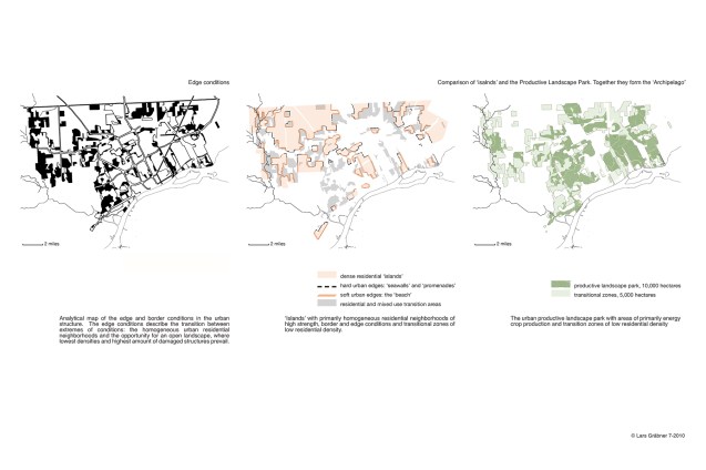
The results of the following investigation might seem to be of morphological and visual nature; however, through the process of mapping, the urban landscape will eventually reveal spatial border conditions, urban transitional situations, productive field conditions as well as coherences in the existing urban context.
Turning our attention to the matter of urban perforation as it appears in Detroit, we will find an astonishing potential in the landscape, when looking through the analytical lens of the map.
