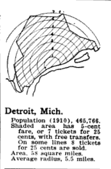
The concentric circles on this map caught my eye accompanied by an odd jagged edge. In 1916, Detroit was much smaller in size than it is today. The 1916 boundary line would fall roughly within this map, but that’s not what the outer boundary line represents here.
This map was one of 15 included in an infographic in volume 48, page 222 of the Electric Railway Journal. Detroit was included among Boston, San Francisco, and Washington D.C. along with Buffalo, Milwaukee, and Kansas City. The circles represent miles distance from the “traffic center” or the city.
