DETROITography

Menu

Skip to content
  • About
  • Our Maps
  • Events
  • Neighborhoods
  • Resources
  • Find Data
  • Learn
  • Participate

Map: Detroit Youth Not Enrolled and Not High School Graduates 2000

August 26, 2020 By Alex B. Hill

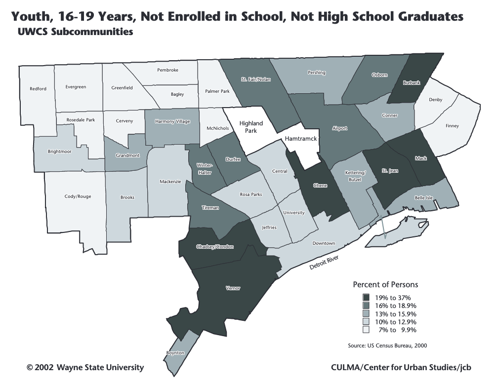
The current pandemic and school reopenings reminded me of an earlier map metric called “disconnected youth.” The WSU Center for Urban Studies mapped the metric in 2002 by “subcommunities” based on the 2000 Census. I expect the numbers will only get worse following 2020 and beyond.

Share this:

  • Click to share on Bluesky (Opens in new window) Bluesky
  • Click to share on LinkedIn (Opens in new window) LinkedIn
  • Click to share on Nextdoor (Opens in new window) Nextdoor
  • Click to email a link to a friend (Opens in new window) Email
  • Click to share on Facebook (Opens in new window) Facebook
  • Click to share on X (Opens in new window) X
  • More
  • Click to print (Opens in new window) Print
  • Click to share on Reddit (Opens in new window) Reddit
  • Click to share on Pinterest (Opens in new window) Pinterest
Like Loading...

Related

Posted in Demographic, Education, Employment | Tagged 2000, Census, Center for Urban Studies, College of Urban Labor and Metropolitan Affairs, Detroit, disconnected, high school, Jason Booza, map, subcommunities, Wayne State University, youth | Leave a comment |

Post navigation

← Map: Electric Vehicle Charging Stations in Detroit 2020
Map: Detroit’s Child Care Desert 2018 →

Leave a comment Cancel reply

Around Art Buildings Crime Data Demographic Economic Education Employment Environment Events Food Health History Income Land Parking Podcast Politics Population Property Race Transit

Popular

  • Map: Borders of Detroit
    Map: Borders of Detroit
  • Detroit Redlining Map 1939
    Detroit Redlining Map 1939
  • Map: Detroit Urban Streams Restoration
    Map: Detroit Urban Streams Restoration
  • Map: Detroit's Connors Creek Sewer System 1895
    Map: Detroit's Connors Creek Sewer System 1895
  • Map: Detroit Neighborhood Enterprise Zones and Homestead
    Map: Detroit Neighborhood Enterprise Zones and Homestead

Enter your email address to follow this blog and receive notifications of new posts by email.

Join 6,808 other subscribers

Books!

Follow

Tweets by detroitography

Like

Like
Subscribe
Create a website or blog at WordPress.com

Contact

Submit a map or just get in touch. Thanks for following!
hello@detroitography.com
×
  • Comment
  • Reblog
  • Subscribe Subscribed
    • DETROITography
    • Join 630 other subscribers
    • Already have a WordPress.com account? Log in now.
    • DETROITography
    • Subscribe Subscribed
    • Sign up
    • Log in
    • Copy shortlink
    • Report this content
    • View post in Reader
    • Manage subscriptions
    • Collapse this bar
 

Loading Comments...
 

    %d