Map: Detroit Vacancy (warning: strobe effect)

detroit_vacancy_castilla

This awesome map was shared by Jaime Castilla Santos, an architecture student from Spain (ETSAM). His thesis is focused on finding a new way of manage and plan the city, through a system that locates opportunity areas in the city to creates collective and interactional spaces.


Map: Will Walk (from AMP) for Food in Detroit’s Cass Corridor

WillWalkAMPBy: Helen Lee

“Will Walk (from AMP) for Food” maps out food establishments by distance (miles) from the Allied Media Projects (AMP) office. Food establishments are also categorized by the most expensive entree displayed on their menu (as indicated by the map key). The map was generated in QGIS and participants in the workshop along with the facilitator worked together to collect the data used in the map.


Helen completed this mini mapping project as part of the “Data, Mapping, and Research Justice” workshop offered through Co.Open and Allied Media Projects. Learn more at: http://coopen.co

Open Green Spaces Map: Creating a network of parks, gardens, and public art in Detroit

Mini Mapping Project MariselaBy: Marisela Castañeda

In my mapping project I looked at existing green spaces within the Cass Corridor. Currently there are many open green spaces in the Cass Corridor but most of these spaces are misused serving as makeshift parking lots and illegal dumping sights. Although these green spaces are open and accessible to the public they are not managed, not maintained, and they do not form a green network.

I believe that these open green spaces should prioritize people over cars and materials and this is where gardens and public art comes into play. Parks help to promote exercise and recreation activities and gardens provide food and create a space for us to reconnect to the land. Meanwhile, public art promotes community engagement and encourages walkability within the area. Parks, gardens, and public art are complementary elements that work together to build a green network in the Cass Corridor.


Marisela completed this mini mapping project as part of the “Data, Mapping, and Research Justice” workshop offered through Co.Open and Allied Media Projects. Sign up for the March workshop session and learn more at: http://coopen.co

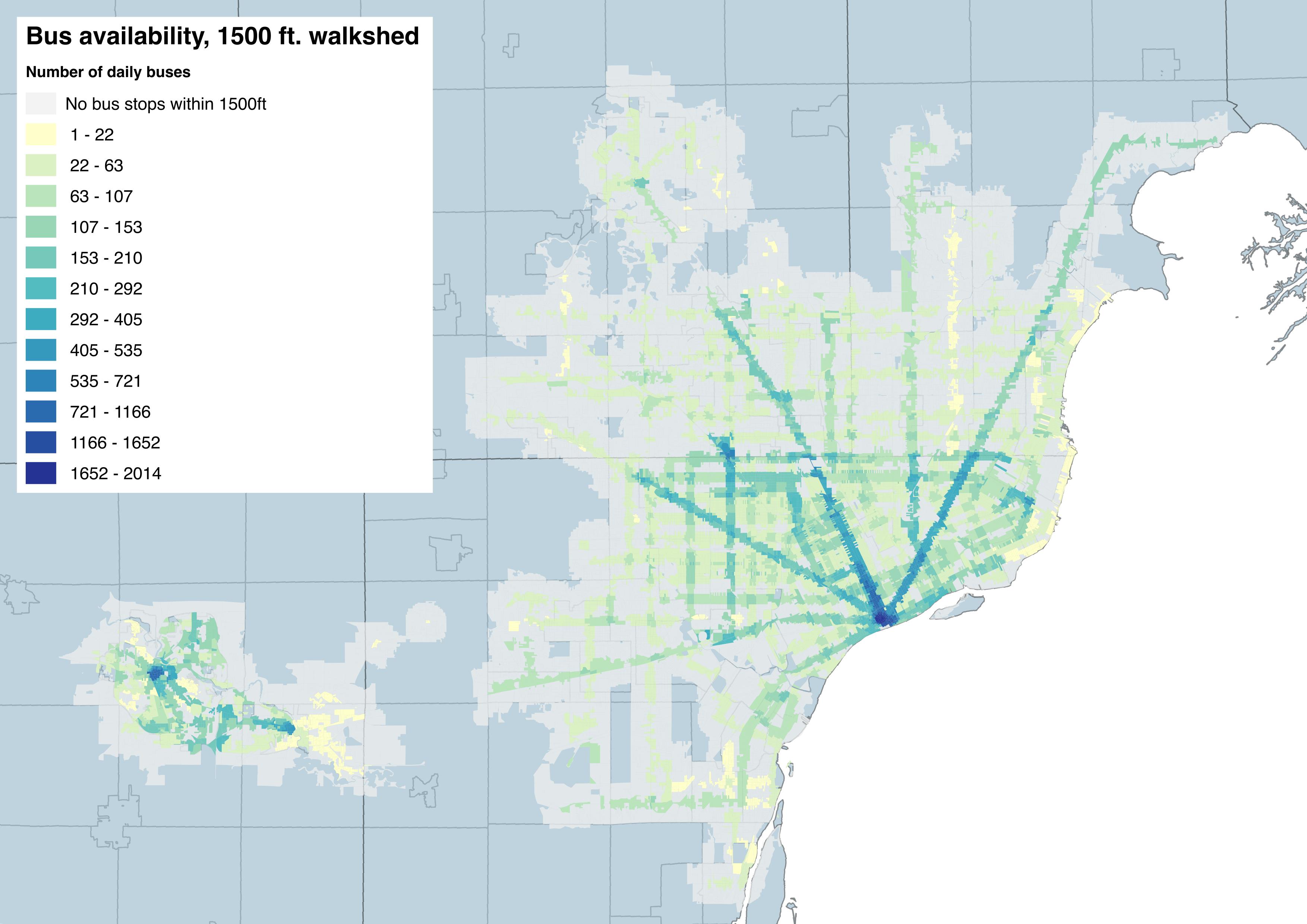
Map: Detroit Bus Availability and Walkability

det_bus_accessibility

by contributor: Jimmy McBroom

“This is a map of accessibility to the fixed-route bus system in Metro Detroit. For each block, this measure was derived by looking at the bus stops within a 1500 foot walking distance (that’s about an 8-10 minute walk). By measuring the individual routes that service those stops and the frequency of those routes, a measure of total bus trip availability was generated. For instance, since most blocks in Downtown Detroit were within a 10 minute walk of the Rosa Parks Transit Center, the number of available daily bus trips for most downtown blocks are in the 1500-2000 range. You can see similar clusters of accessibility in downtown Detroit, along the Woodward and Gratiot corridors, and near Northland Mall. Stop location & route frequency data was generated using a weekday schedule, using GTFS data from AATA, DDOT, and SMART. Census block data was derived from US Census TIGER/LINE files.”