
by: Janet Anderson
I’ve spent my entire career, and my six decades of life, living with the results of unplanned land use. I watched Detroit’s legendary decline from my front porch and in my city of Detroit work, and I continue to see and feel the disconnects between what people need to thrive and what is built near them. As a planner of public services, I’ve heard so many laments that city of Detroit management caused its own decline. Working papers of the Detroit City Plan Commission (CPC) in the 1950s are a fascinating counter to that.
I collected the documents behind Detroit’s 1946 and 1954 Master Plans when I was writing my dissertation. Now, these reports and others, can be accessed through The Online Books archive: Detroit (Mich.). City Plan Commission. The maps show CPC staff trying to understand forces affecting Detroit’s residential and economic bases, even before mass exodus. They surveyed business establishments and collected statistics from other great industrial centers. They drove every block and recorded observations of building conditions, developing a condition rating system for housing and industry that teed up pressing issues.
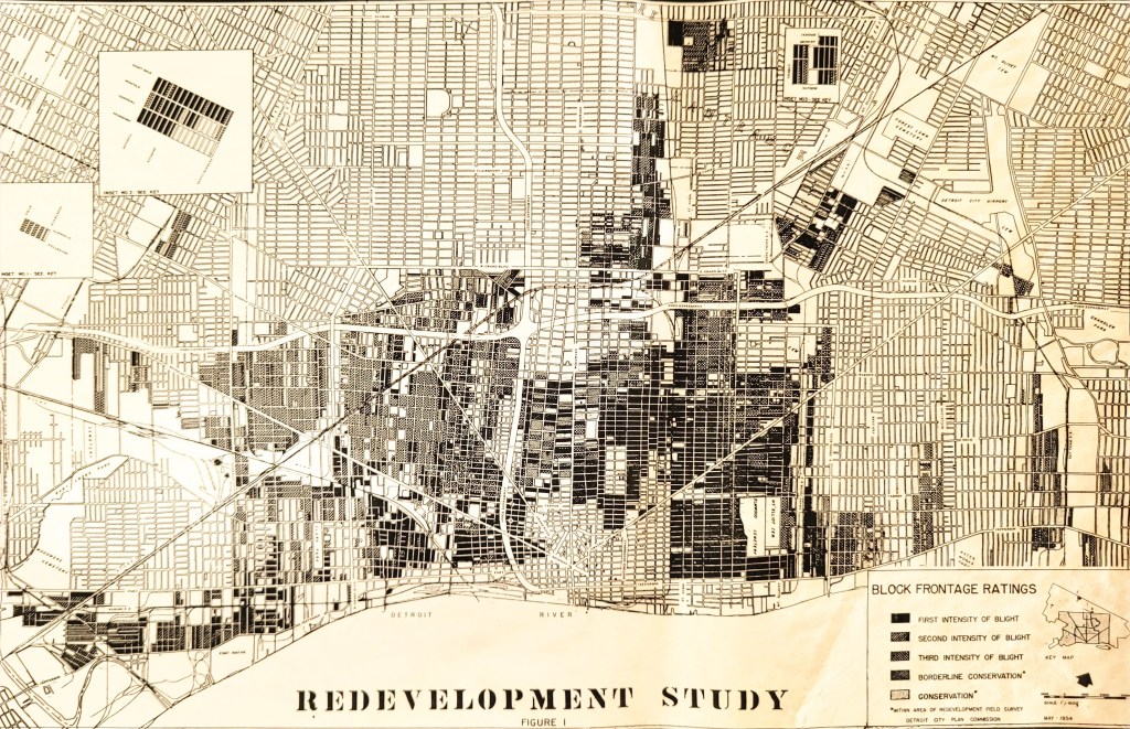
The “Redevelopment Study” map classifies frontage conditions in the oldest sections of the city. These were visual assessments of structures (foundations, plumb, roof, rot, heating) and their environment (cleanliness, overcrowding, traffic, commercial nuisances). Defined criteria can support needed discussion: for example, is a co-located storefront, or lack of parking, always blight?
Where whole sections are in the darkest (most blighted) category, wholesale clearance interventions were devised, such as what is now Lafayette Park. Blocks with few building problems (lightest fills) were slated for conservation which involved educational outreach to homeowner associations. In my early years, I knew of no direct city government outreach, so this seems groundbreaking.
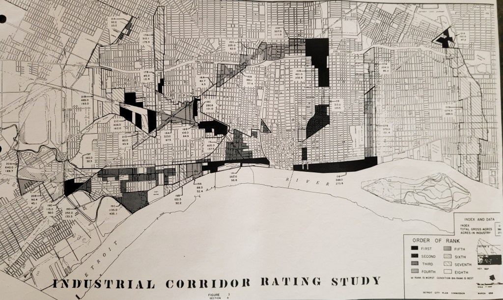
CPC studied options for renewal in industrial areas, many of which mixed residential, commercial and other uses. A rating system was built from opinions of manufacturing and non-manufacturing businesses (dissatisfaction with streets, plant layout or size) and from facility characteristics (yard loading or storage; number of stories; building coverage of land; off-street parking; age; owner occupancy). This allowed them to target conditions correlated with owners’ desires to move.
The “Industrial Corridor Rating Study” map is the result. Other maps analyzed factors such as shift employment and average commute distances. So much work highlighted the relative neglect as well as obsolescence of then-century old corridors. Maps often lead us to ask more questions.
I feel a kinship with the CPC staff who urgently grappled with Detroit’s disadvantages in the highly competitive postwar metro area. I think of my time struggling to downsize Detroit’s built footprint during our historic insolvency while urban sprawl continued. Land use in metro Detroit today should inspire this sort of urgency. We have to find a way to bring planners’ maps into the minds and hearts of all stakeholders, without whom, improvements in my lifetime are hard to imagine.
Janet Anderson, PhD is a lifelong Detroiter and urbanist with 30+ years planning public services for the city of Detroit and the Public Lighting Authority of Detroit. She has a PhD in Urban Policy Analysis and is on faculty of Wayne State University’s Public Administration Program, and she writes a free Substack “The Commons: All About Us”


Janet–Thanks for this informed reconsideration of some standard ways of looking at the decisions of Detroit’s 1950s-era planners. Really helpful. –Frank Rashid